June 25, 2017

The Hot One Today

Temperatures on Saturday were toasty around the region (see below), with upper 80s reaching into Puget Sound, near 100F in Portland, and over 100F in portions of the torrid Willamette Valley.   As predicted, temperatures surged into the low 90s along the WA coast due to offshore (easterly flow).


Temperatures are warmer this (Sunday) morning over much of the region by roughly 5F, and a key parameter (the Seattle-Yakima pressure difference) suggested a large offshore pressure gradient (that helps warming)...see the table below.  The pressure differences between Seattle and the coast are still negative (higher pressure in Seattle), which suggests no push of marine air during the day today.
A really useful tool for short term forecasts of temperature is to look at time-height cross sections of temperatures and winds from aircraft coming in to Seattle and Portland.   Here is the latest from Seattle (red is temperature, the vertical axis is height in pressure, with 850 being around 5000ft.  Time increases to the left and is in UTC/GMT).   850 hPa temperatures are around 22C (which are very warm) and could support surface temperatures as high as 37C (upper 90s), where there is no marine influence.

In fact, the 850 hPa (about 5000 ft) temperature at Quillayute, on the WA coast, is at record high levels for the date (see climatology at the radiosonde site there, with red being record highs, the dot is the temperature at 5 PM yesterday).

Consistent with this, here is the latest high resolution UW WRF forecast for 5 PM.  Mid to upper 90s away from the water (eastern Seattle suburbs and lower western Cascade foothills). You don't want to know about Portland and the Willamette Valley, where 100F+ will be widespread.

So today is going to be very warm... so be prepared.   I close my shades and fill my house with cool morning air with fans.  But it will be the last day of the uber-heat and there is already a sign of change....low cloud are starting to move up the Oregon coast.  An indication that an onshore push of marine air may be in store for tomorrow.


June 23, 2017

Weekend Heat Wave

The warmest days of the year so far  over the Northwest are coming up this weekend and some folks in western Washington will be sweating with temperatures exceeding 90F.  Today got to 81F at SeaTac...as perfect a day as one can imagine.

The Weather Channel revs up Seattle's temperature to 86F on Saturday and 89F on Sunday, before cooling down on Monday.  I suspect temperatures will be considerably warmer east and south of Seattle this weekend.


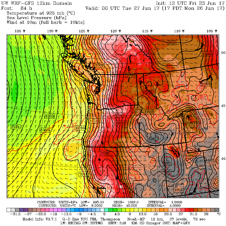
To get the big picture, let's start by looking at a sequence of forecasts of sea level pressure (solid lines), surface winds, and lower-atmosphere temperatures (cold shading).

At 5 PM today, one notes low pressure over the CA interior and western Oregon that is coincident with warm temperatures (hence the name, thermal trough).  This thermal trough is associated with offshore (easterly) flow forced by building pressure east of the Cascades.  Today, with the thermal trough south of western Washington,  there are cool northerly winds over Puget Sound.


Tomorrow at 5 PM is much warmer over western WA and Oregon, as the easterly flow moves northward.

 By 5 PM on Sunday, major changes are occurring.  Temperatures peak over western WA and the thermal trough has just "jumped" over the Cascades into eastern WA.  The warmest day for Seattle, but cooling starting on the coast.

 The effects of the thermal trough moving east of the Cascades is really obvious at 5 PM Monday.  Marine air and a large pressure difference has moved into western Oregon and Washington.
Taking a look at the surface (2-meter) temperature forecasts from the super high resolution UW WRF forecast model, today at 5 PM shows low 80s into SW Washington and southern Puget Sound.

 24 hour later, a MUCH warmer story, with upper 80s and lower 90s over SW Washington and 90s in the Willamette Valley.
 Sunday at 5 PM is even warmer, particularly over the western interior and the Columbia Basin.  Portland will be white hot!  And you will notice some coastal cooling.


It is, of course, dangerous to look at one forecast solution....so let's check out the latest National Weather Service higher-resolution ensemble (called SREF) for Seattle.  Most of the forecasts are for low 90s in Seattle.  Quite a bit of confidence in this forecast.


So find a fan and a cold drink...you will need them during the afternoon and early evening on Saturday and Sunday.

The Atmosphere is Providing Water Where It is Needed

There is a deep connection between meteorology and religion, and there are times when one wonders about divine intervention in our weather. ...