November 22, 2017

Tropical Air over Seattle

Breath deeply this morning. 

A few days earlier the air was over the tropics.  Moist, warm and soothing to our wind and cold whipped skin.  And we just broke a major low temperature record.  This morning, our low temperature (56F) was the HIGHEST low temperature ever recorded in November at Seattle Tacoma Airport.  That is a big record to break.

Yesterday, Bellingham broke their daily high temperature record (60F) and today all sorts of daily high temperature records will be broken around the region.  


To certify the tropical origins of our air, I used the NOAA Hysplit trajectory model to trace the origin of the air above us at 500 meters (blue), 1500 meters (red), and 3000 meters (green) for the past 150 hours.  Our low level air, came from just east of Hawaii.  The 1500 meter air from the deep tropics.  No wonder many of us are fighting the urge to grab a Mai Tai today.


A plot of the winds and temperatures above Seattle for the past day (below), shows a freezing level of 10,000 feet, with strong southwesterly winds aloft--a sign of a potent atmospheric river event.

Over the past 24 hr (ending 5 AM), portions of the SW slopes of the Olympics received over 6 inches of rain, with the north Cascades getting as much as 3-5 inches.


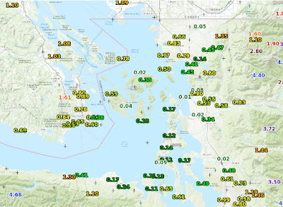
But perhaps more impressive than the rain on the windward sides of the mountains, is the profound rain shadowing in the lee of the Olympics, where some locations only received 1-2 hundredths of an inch (see below).  Just amazing.

However, the wacky weather award yesterday had to go to Bellingham, Washington, where in less than an hour (around 4 PM Tuesday),  the winds turned southerly and surged to over 40 knots, and the temperature rose from 46 to 60F (see report below).


The temperature trace there shows the story and the fact the temperatures are EVEN WARMER right now--62F (and there are strong winds at Bellingham currently as well).
Perhaps just as unusual was the existence of sea fog (a.k.a., warm advection fog) over Lake Washington  this morning (see below).  The air was so humid and warm (dew point at Seattle-Tacoma Airport was 57F at 7 AM), that the cooler waters of Lake Washington (51F according to the Lake WA buoy) was able to bring the air to saturation.


The temperatures today will delight you.  A plot of temperatures during the past two weeks at Seattle shows that our current morning temperatures are WAY higher than the normal highs (purple line below).
 And the UW high resolution model forecast for surface air temperature at 2 PM  today shows 60s all over western Washington.  Some locations in the upper 60s.


 So pull out a short-sleeve shirt and breath in the tropical air.  Today, will not feel like normal Seattle weather fare of November.


November 21, 2017

Warm Temperature Records Will Fall As A Strong Atmospheric River Hits the Pacific Northwest

The next 48-hr will be stunning in a number of ways:  very heavy precipitation in the mountains, river flooding, and temperatures that will reach record levels.

The forecast for today at 1 PM, shows the story, a strong plume of moisture from the south that is heading directly into the Northwest (blue and white colors indicate the largest values).


The moisture channel satellite image from last night at 9:30 PM shows an amazing plume of water vapor heading directly from the tropics.  It has our name on it.

Accompanying this plume of tropical moisture will be near-tropical warmth, something illustrated by a forecast chart for 1 PM Tuesday at the 850 hPa (about 5000 ft) level.  Red/orange are warm temperatures, driven northward by powerful southwesterly flow aloft


Or we could look at the forecast temperatures (red lines, °C), winds, and humidity (shading) over Seattle (see below). Time increases to the left and the heights are in pressure (700 hPa is 10,000 ft). The blue line is the freezing (0°C) level. 

Unbelievable...the freezing level rises about 10,000 ft.  This means rain everywhere...even over the high terrain of the Cascades.  The atmosphere is very moist (green colors), with strong southwesterly winds aloft.


Now let me show you the  forecast precipitation with 24 hour totals.

Ending 4 PM Tuesday...heavy rain in the mountains, with 2-5 inches in the Olympics.

 Even more the next 24h (ending Wed. at 4 PM)

 Just as much the next 24 h.  Yikes.


Add them all together for the 72h total ending 4 PM Turkey Day.  Much of the mountains get 5-10 inches, with a few places in the Olympics getting more.  Expect flooding on a number of rivers. And  yes, our snow will do some serious melting.


 But what really will be amazing will be the temperatures.  Here are the forecasts from the National Weather Service SREF ensemble for Seattle...many of the members will reach into the LOWER 60s on Wednesday....probably breaking the daily record.


Well...this is climatologically the wettest weak of the year!

The Puget Sound Convergence Zone Delivers and Well-Timed Precipitation and Smart Water Manegament Keep Yakima Crops Yields High

Before I get into the Yakima Valley situation, let me note yesterday's substantial precipitation over central Puget Sound from a decent ...