April 04, 2018

Monster Late-Season Atmospheric River Will Hit the West Coast With Heavy Rain and Strong Winds

An extraordinarily strong atmospheric river will hit the West Coast starting tomorrow in the Pacific Northwest and then moving southward into California on Friday and Saturday.

A monster that will be one the strongest on record, particularly this late in the season.  And to add to the fun, an extremely powerful storm will form off our coast, bringing very strong winds over the Oregon coast.  Again, very unusual this time of the year.

Just a reminder-- an atmospheric river is a narrow current of high moisture values,  originating in the tropics and subtropics, that is associated with warm air and heavy rain, particularly when into coastal terrain.  In our neck of the woods, atmospheric rivers are often termed a pineapple express.

Satellite-measured integrated water vapor product this morning shows large values in the tropics (orange, red, and purple) with high values starting to move northeastward towards the North American west coast.

Let's start by viewing the UW WRF model's forecast of column-integrated water vapor...the amount of water in vertical column of air (see below).  The dark blues indicate very, very high levels, white and red are high values, with lesser values shown in green and light blue.

At 5 PM today (Wed), a tongue of modestly high values reaches the Pacific Northwest coastline.


One day later (5 PM Thursday), a much more threatening situation has developed.  Huge values (blue colors) are now in a very wide atmospheric river that is directed right at California.


Friday at 5 PM is stunning.  An extreme atmospheric river (blue all the way) is hitting California.

 And during the next 12-h (5 AM on Saturday), the river moves southward, bring heavy (and very unusual) rain to southern California---with the threat of causing more landslides from the debris from the December fires.


By Sunday, the atmospheric river moves out, but there is little relief for the sodden California folks, with another (but weaker) event late Monday and Tuesday (see below).


How much precipitation will California and the Northwest get?  Here are the precipitation totals for the next 8 days from the European Center model (courtesy of weatherbell.com). For California, we are talking about as much as 4-8 inches in terrain and heavy amounts (over 2 inches) over much of central and northern CA.  Remember April is typically a month that California dries out as the jet stream usually moves north.


Here is the Northwest, we will get a piece of the action, with several inches everywhere, but particularly heavy precipitation on the Olympics and in southern BC.
This is really an historic event that is very unusual for this time of the year.  Let me prove this to you.  Consider the forecast for water vapor in a vertical column for Friday at 11 AM, and lets display it as the percentage of normal (below).  OMG!  The values approaching the coast are 300-400% of normal!


 For those who know some statistics, we can see how far from normal the values are in terms of standard deviations (see below).  Large area above 6 standard deviations, which means we are talking about unprecedented values.


The National Weather Service has a flood watch out for the Sierra Nevada mountains and a heavy snow warming for the Cascades.

But the extreme action is not just with precipitation.  An amazingly strong oceanic cyclone will develop and move up the Northwest coast.   Take a look at the sea level pressure map forecast for 5 AM Saturday (below).  A deep (972 hPa low) west of Washington State, with a huge pressure gradient to its south and west.  That means big winds.


Here are the forecast wind gusts at that time--above 70 knots to the south of the low, with the Oregon coast getting hit hard (50+ knot gusts).


The low will slowly move up the coast, crossing northern Vancouver Island late  Saturday (see map at 5 PM Saturday below).  Big pressure gradients along the Washington Coast...so major wind event there.  Expect coastal power outages.


Having such a strong storm in April is unusual, but not unprecedented.  Anyway, this is getting exhausting....too much weather.  But we are in for an interesting period.  But one good thing...one can forget about West Coast drought or any water issues for this summer.  Our tank is about to be filled...if not overfilled.
_________
Announcement:  The Northwest Weather Workshop is on April 27-28

The NW Weather Workshop is the big annual meeting for those interested in Northwest meteorology.  This year we will have a major session on the meteorology of NW wildfires and others on other aspects of our regional weather.  The gathering takes place at the NOAA facility in Seattle.  To view the agenda and to register, go to the meeting website.  The workshop is open to everyone, but registration is required.

April 02, 2018

A Convergence Zone Snow and "Hail" over Central Puget Sound with Deadly Consequences

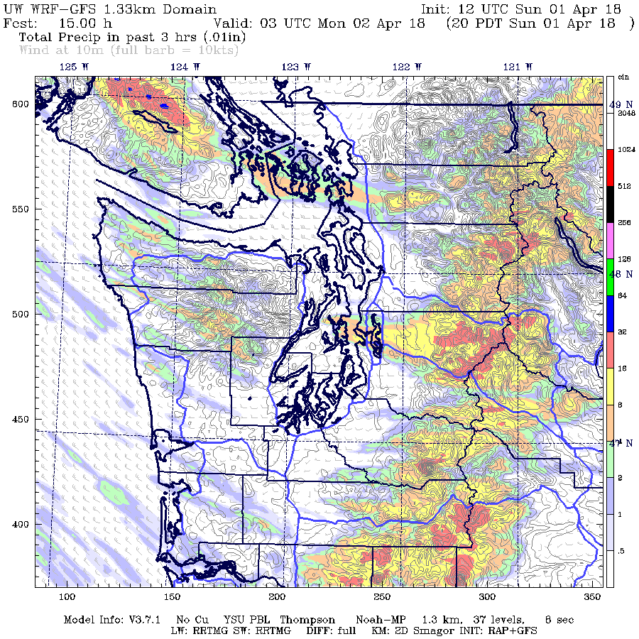
A very strong Puget Sound convergence zone formed yesterday evening, bringing heavy rain, snow, soft hail, and lightning in a band from north Seattle into the Washington Cascades.

And it was a convergence zone with serious consequences, leading to dozens of accidents, the closure of I-90, and the death of a woman and her unborn child.

As a reminder, a Puget Sound convergence zone forms when low-level westerly/northwesterly flow on the Washington Coast is forced to move around the Olympics and then convergences over Puget Sound.  Such low-level convergence forces upward motion, clouds and precipitation that stretches from the Sound to west side of the Cascades (see figure).


Convergence zones really rev up when two things occur:  (1) an unstable atmosphere, in which temperature cools rapidly with height,  and (2) an environment with upward lift.

We had both of them last time. The air aloft was very cold....in fact, the air at 5000 ft (850 hPa) was near record levels.  This is illustrated by the figure below, which shows the climatology of 850 hPa temperatures at Quillayute, on the WA coast.  The blue line shows the record lows for the date and the gray circle was the observed value yesterday at 5 PM.  Pretty much tied the record cold for the date at that level!

And there was very strong general lift from a well defined upper level trough moving into the region (see the 500 hPa...about 18K foot...map at 8 PM Sunday).


The visible satellite imagery at 6 PM yesterday showed a classic convergence zone signature.  You can see the thin enhanced band over Puget Sound that widens and stretches towards the Cascades.  The classic clear areas to the north and south of the band was evident-- due to sinking air in the lee of the Cascades and mountains of Vancouver Island.  And percolating, unstable air offshore (you can see the convective clouds).   Just perfect.


The convergence zone was very evident in weather radar imagery.  Here are some 1-h precipitation totals based on radar data... you can see the band of convergence precipitation over the Sound and the HUGE enhancement on the western slopes of the Cascades.


Some lighting was produced by the relatively deep cumulonimbus associated with the convergence zone.   The lightning detection network showed on strike right over Seattle (see below)


You could get a great view of the situation from the Space Needle PanoCam.  Looking south, the clear zone was evident.


But turning 180 degrees to the north one was viewing the jaws of deep clouds and heavy rain.


With very cold air aloft (about -6C at 850 hPa....5000 ft), we started with a very low snow level (around 1000 ft).  So getting snow in the passes was no problem.   Snoqualmie got hit hard, with 16.5 inches of new snow reported.  The pass closed last night and was still closed....as spinning out cars and tracks blocked passage.


But with such a low snow level and heavy precipitation, snow pushed down to lower elevations, and started covering I 90 down to North Bend (see image from Eastside Fire Rescue).  Dozens of accidents occurred, including the terrible fatality crash noted earlier.


And near sea level, there was a number of heavy "soft hail" and graupel (small while ice particle) showers that turned the ground white in places.

The threat of a convergence zone was clear earlier during the day, as was the low snow level.  Here is a forecast of the 3-h precipitation ending 8 PM Sunday, from the UW WRF model run made 5 AM Sunday morning.  Not bad.


Seeing this situation, I believe we need to find a way to provide folks with better real-time warnings when this kind of situation occurs, including the use of WSDOT reader boards to slow traffic way down when such features occur.    People tend to drive too fast when such inclement weather occurs and WSDOT and my profession need to build an infrastructure that will warn drivers and force them to slow before this hit weather hazards such as heavy rain, loss of visibility, roadway ice, and snow on the roadway.  Next week there will be a WSDOT idea session and I will try out some ideas with them.
_________________________________________________________

Announcement:  The Northwest Weather Workshop is on April 27-28


The NW Weather Workshop is the big annual meeting for those interested in Northwest meteorology.  This year we will have a major session on the meteorology of NW wildfires and others on other aspects of our regional weather.  The gathering takes place at the NOAA facility in Seattle.  To view the agenda and to register, go to the meeting website.  The workshop is open to everyone, but registration is required.

Seattle Times Story on Skagit Flooding and Global Warming is Clearly Wrong

 It happens again and again. The Seattle Times Climate Lab runs a story claiming global warming will create a dangerous situation. A story t...