November 03, 2022

Super Rainshadow and the Snow Situation Becomes Clearer

 When we get to within approximately 72 hours before a weather event, powerful high-resolution tools become available, and these can be critical with the complex terrain of our region.  Let me tell you what these tools are telling us.

The Super Rainshadow

The atmospheric river has now made landfall on western Washington and rain has spread eastward across the region.  As predicted, a profound rainshadow is apparent on the latest radar image, with essentially dry conditions over much of Kitsap County east of the Olympics (see below).


The latest super-high resolutin forecast for precipitation over the next 72 hr (below), shows a distinct rainshadow, with less than .5 inches northeast of the Olympics, while up to ten inches is found over the mountains.    And eastern Washington gets super-rainshadow action, will nearly no precipitaitn around Yakima.

And if you like the sound of wind in the trees, there will plenty of that tonight and tomorrow morning, with a huge north-south pressure difference predicted for 11 AM Friday morning.  Expect southerly winds gusting to 20-30 mph everywhere and over 40 mph along the coast, over Puget Sound, and over NW Washington.


Trees will lose branches and some may topple in this early season blow, so be careful out there.

Finally, the cold/snow situation is becoming clearer.   The fact that we will get much colder, with temperatures far below normal is pretty much guaranteed from Sunday onward.  

Here is the forecast anomaly (difference from normal) for 24-h ending Tuesday morning at 10 AM.  

Large portions of British Columbia and Montana will be MORE THAN THIRTY DEGREES below normal.  Much of Washington and Oregon will be 10 degrees below normal and more.


I will be getting my sweaters out of the closet.   And municipalities will have to do what they can to protect homeless people.  Yesterday I saw one individual on the Burke Gilman trail without even a shirt on, with several others sleeping on benches or in the woods adjacent to the trail. 

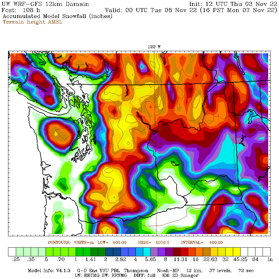
And then there is snow.  The mountains will be buried in the white stuff-- feet of snow--as shown by the predicted totals through 4 PM Monday from a relatively low-resolution forecast (12-km grid spacing).


It is looking quite possible that the western lowlands will see some flakes, but I need more resolution to get this right...and I will have that tomorrow.

But there are two areas of the greatest threats.  Later on Sunday and Monday, cold air will push out of the Fraser Valley into NW Washington, increasing the chance of snow from Bellingham into the San Juans.  Some snow will fall on the northeast side of the Olympics as the Fraser outflow is forced to rise.  And a Puget Sound convergence zone may form around Seattle producing a band of snow over the mid-Sound (hinted in the above figure).

More on this tomorrow and Saturday.


November 02, 2022

Warm and Very Wet Before the Snow and Cold

 Our region will experience wildly gyrating weather extremes over the next week.  

Yes...there is still cold and snow in the forecast.  But before we enjoy the snowflakes, we will experience a strong atmospheric river that will bring very heavy precipitation to the mountains.

And to spice it up, strong winds and an extraordinary rainshadow will occur over Puget Sound country.

First, the atmospheric river.  As shown below, a plume of wind-driven moisture, thousands of miles long, will push into our region on Friday.  The figure shows integrated water vapor transport--essentially how much water vapor is being transported by the wind.    Let me assure you, these are large values.


The huge influx of water vapor will be pushed upwards by our region's mountains, producing intense precipitation.   Below are the predicted totals for 24 hr ending 5 PM Friday.   Wow.  A substantial area over 5 inches in both the Olympics and Cascades.

Look closely and you will notice that Seattle and its vicinity will get less than .1 inches--they will be in the rainshadow of the Olympics.  Why?  Because the winds approaching the Olympics will be nearly westerly (from the west), which shifts the rainshadow to over central Puget Sound.


As with most atmospheric rivers, temperatures will be warm, with the freezing level rising to around 6500 ft on Friday (sorry skiers).  Note that the snow level is often about 1000 ft lower than the freezing level.  Higher elevations will get blasted with snow.  And snow levels will drop quickly on Saturday.

The heavy rain should raise river levels substantially, with the Snoqualmie River reaching flood stage (see the forecast for the Snoqualmie River at Carnation provided by the NOAA/NWS River Forecast Center in Portland)/


And then there will be wind.  Take a look at the predicted winds for 2 AM Friday morning (below):  southerly gusts over 40 knots over much of the region's waterways and 20-30 knots over land.   As the first major blow of the fall, you can expect power outages.  

Since the Friday event is so soon, the confidence in the above forecast is great.

I suspect you want to know about the potential for snow next week.

The predicted snow total through next Saturday (November 12)  by the US GFS model shows massive snowfall over mountains of the entire West.


And yes, some snow over the lowlands of western Washington.   Much of this snow falls on Sunday through Tuesday.   I will examine the snow and cold in much greater detail in my next blog.


________________________________________

A very interesting and intriguing book on dealing with environmental issues has just come out: Time to Think Small: How Nimble Environmental Technologies Can Solve the Planet's Biggest Problems by Todd Myers.   Amazon link here.

Mr. Myers discusses how diverse, distributed actions (such as farming techniques that reduce CO2 concentrations in the atmosphere) can play an important role in mitigating global warming.  He even has a section on my work with smartphone pressures.  His main point is that local/regional actions or the application of "crowdsourced" technologies can make a big contribution to dealing with environmental issues.  


Tens of Thousands Have Lost Power as a Strong Cyclone Makes Landfall

As the models predicted, a strong storm with powerful winds is moving across our region, and nearly 100,000 customers are without power as I...