June 05, 2023

Cold Water Along the West Coast and Unusually Cold Over Southern California

 If you want sun and warmth, don't travel to southern California during the next week.   

Stay in the sunny Pacific Northwest, where the weather will be as close to perfect as one might imagine.

Much colder than normal water is found off the West Coast from Oregon to Baja, and southern California is cold and enshrouded with clouds (see visible satellite image a day ago).  June Gloom+


Sea Surface Temperatures

Here is the latest plot of sea surface temperatures along the West Coast, with large stretches below 50F (purple colors, below 10C).  Too cold to swim in!
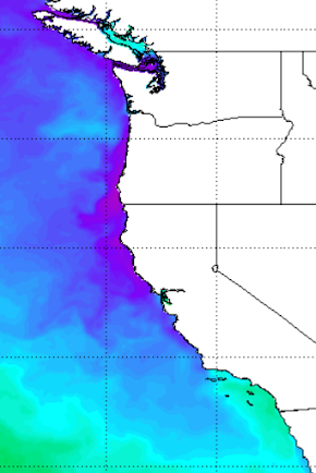
Much of the offshore waters are well below normal, as indicated by the blue colors below.

Why are the coastal waters so cool?   Probably, two reasons.

First, there have been persistent, unseasonable low-pressure areas that have repeatedly formed off southern California.  

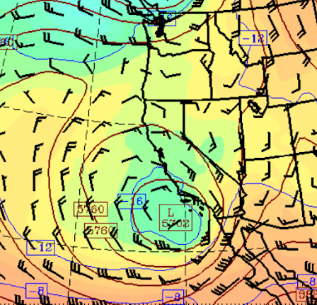
To illustrate,  the upper-level heights at 500 hPa (think pressure around 18,000 ft) this morning are shown below.  A low with a nice counterclockwise circulation is just offshore of southern California.  Such lows are associated with stronger winds and atmospheric disturbances that stir up the upper ocean, mixing cooler water from below up to the surface.

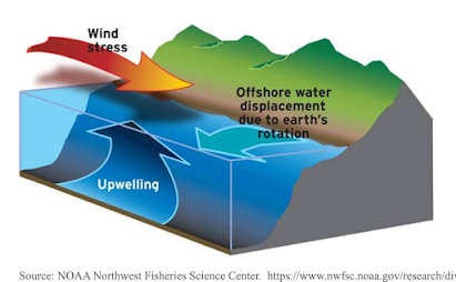
And then there have been periods when high-pressure builds offshore and northerly winds develop over the waters of northern CA and Oregon.  This pattern results in coastal upwelling of cold water within 100 miles or so from the coast (see a schematic of coastal upwelling below).

Unfortunately for the chilled residents of coastal California, powerful northerly winds will develop offshore this week as a strong high-pressure area builds over the northeast Pacific (see forecast pressure and winds for Sunday).

It will be like putting a refrigerator element along the West Coast!

San Diego and LA Chill

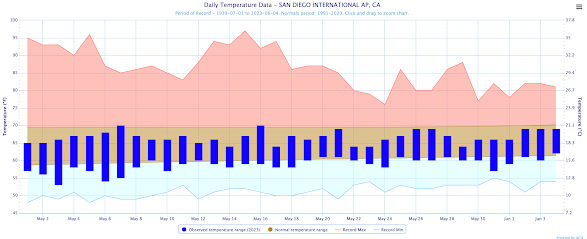
    To understand how bad it has been, take a look at the observed temperatures at San Diego (blue bars showing daily highs and lows), compared to the normal range (brown band),  Record highs and lows are also shown.  

All days but two did not reach the normal highs.  The lows on most days dropped below the normal lows.  NO heatwaves.


And the frigid situation (with rain by the way) is not ending.  Below is the latest extended temperature prediction for Los Angeles Airport.  Not a single day above the mid-60s.  Boring and cold.


For the same period, Seattle will be basking in temperatures from the 80s to the mid-70s, with enough variability to make it interesting.


I suspect you will see the front page of the Seattle Chamber of Commerce website reflect the new weather realities:

  Note: this is not an actual page, but a fanciful simulation of one.


June 02, 2023

Was May the Warmest in Northwest History?

During mid-May, when western Oregon and Washington were in the throes of a several day heat wave, while smoke from Alberta fires was moving in overhead, there was considerable talk about May being the warmest in the historical record for the region.

Was it a record?  Is May getting warmer in the Pacific Northwest?  Is global warming influencing May temperatures?

This will be the topic of this blog.

To begin, consider the difference (anomaly) from normal for the last 30 days for the average maximum temperatures (below).    Much warmer than normal for the northern tier of states, including Washington (as much as 6-10F in locations), but MUCH colder than normal in California and the Southwest.  

Folks I know in southern California have complained vehemently about unusual cold and wet conditions during May.


May in western Washington

    Let me begin by showing you the long-term temperature statistics for Olympia, Washington.  

Why not SeaTac?  

Because of the addition of a third runway and the substantial urbanization and development around SeaTac, its observations are NOT reliable for climate studies.  Far fewer changes and a more rural character for the area around Olympic.

First, consider the mean maximum for May at Olympia, going back to the early 1940s.  May 2023 was the third warmest on record.   But also note that May 2022 was one of the coldest and that there is no long-term trend for high temperatures at Olympia, suggesting climate change is small for that parameter.


What about the highest temperature observed in May for Olympia (see below)?  May 2023 was warm but a number of months were nearly as warm.  Importantly, there is no upward trend of extreme high temperatures in Olympia.


But the story is different for average May minimum temperature at Olympia, which has risen from roughly 41F to 43F.   

It is well known that increasing greenhouse cases have more influence on daily low temperatures than high temperatures.  Furthermore, local development (and there have been some near Olympia Airport) influence low temperatures more than highs.


May in eastern Washington

    Let's review the temperature in Kennewick, Washington in the Tri-Cities.  This station has a very long record (back to the 1890s) and far less localized development (below). 

May 2023 had warm high temperatures, which were exceeded several times druing the 1920s-1950s.  Note there is a DOWNWARD trend in the high temperatures at Kennewick.  I repeat: downward.

This plot is also a good illustration of why long records are important.  A record going back only the 1970s would suggest 2023 was the warmest ever observed, inspiring all kinds of headlines in local newspapers.  But a longer record, such as at Kennewick, shows that such temperatures were frequently observed in the past and that the long-term trend is downward.


The extreme monthly high temperatures in May for Kinnewick are DECLINING and 2023 was nothing special (below).


In contrast, the mean minimum temperature has risen by approximately 2F during the past century at Kennewick, with 2023 being the second warmest on record.


The Bottom Line

    May high temperatures on both sides of the Cascades were warm, but not record-breaking.  Importantly, there is no upward trend of the high temperatures on both sides of the Cascades, suggesting that global warming/climate change is having relatively little impact on the region's high temperatures.

In contrast, low temperatures have warmed modestly (roughly 2F) during the past century and part of that might well be due to anthropogenic warming resulting from increasing greenhouse gases (most importantly CO2 and methane) and increasing urbanization and development in the vicinity of temperature sensors.  Low temperatures are also more sensitive to wind anomalies from normal.  For example, May 2023 had far more easterly (from the east) winds, which tend to cause minimum temperatures to warm.


Smoke in the West Means Relief in the East. The Big Threat Comes Later this Week

As predicted, the winds aloft have turned easterly (from the east), resulting in smoke from eastern Washington moving aloft over western Was...

