August 16, 2020

Extreme Heat Followed by Showers and Thunderstorms

Today was a day of amazing contrasts, with record high temperatures followed by thunderstorms and light rain.
Picture courtesy of NWS Seattle

A line on showers and thunderstorms moved through tonight... welcome relief from a record-breaking day of heat.  The models had been suggesting for days that a line of showers/thunderstorms would move up the east side of the Cascades, but with only a small chance of reaching the western lowlands.

The cause?  A weak upper level disturbance that helped release the instability inherent in the warm air present over the region (see map, the arrow indicates the disturbance).


The upward motion associated with the upper level feature was apparent in the high clouds that spread over western Washington this afternoon.  And the mid-level instability was suggested in some altocumulus clouds that began to form mid-afternoon (both apparent in the SpaceNeedle cam around 2 PM shown below


By 7 PM, the cloud mass associated with convection and thunderstorms was pretty impressive (see below).


And the radar image at 8 PM clearly indicated the showers and thunderstorms.
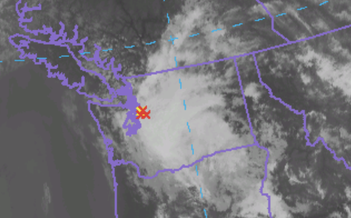


I saw a few lighting strikes myself and the lightning network provided further evidence.


The morning forecasts did not suggest too much moving into western Washington, but the 5 PM NOAA/NWS HRRR model forecast, the highest resolution modeling system run by the NWS was reasonably good (see forecast below for 9 PM).   My research group at the UW is working on more advanced lightning forecasting technology, combining state-of-science model output with machine learning, that should be able to do better.  This research is sponsored by Seattle City Light, which is concerned about lightning for obvious reasons.


Finally, just wanted to note the extraordinary high temperatures today, with several locations getting to 100F (see below, click toe expand).   Some significant records were broken today, with many daily records surpassed.  Thankfully, tomorrow should be about 10F cooler.

__________________________________

My blog on KNKX is found here.
I would like to thank all of you for your support. Together we will protect freedom of speech and respect for diversity of viewpoints.
______________________________

August 15, 2020

Puget Sound's Unknown Air Conditioner Has Turned On

My blog on KNKX is found here.
I would like to thank all of you for your support. Together we will protect freedom of speech and respect for diversity of viewpoints.
______________________________
Every resident of Puget Sound has a powerful air conditioner at hand and that AC turned on today.  An AC that limits the lengths of our heat waves and draws in cool air while across Puget Sound while Portland and the Willamette Valley are sweltering.
You may have noticed the switch being turned on today, with brisk winds from the north moderating the heat.  This AC occurs because of the particular terrain of our region and how heat waves develop here.

You can see the special AC in action in the next figure, which shows the surface air temperatures and winds at 2 PM.  90s in Portland and the Willamette Valley (pink colors), but greens and yellow around Seattle and Puget Sound-70s and 80sF.  

Look at the winds!  There are northerly over Puget Sound, drawing in  air was was cooled over the Straits of Juan De Fuca and Georgia.


The observations at 2 PM support this prediction (see below), with temperatures around 80F near Seattle, but mid-90s around Portland.  And northerlies around Puget Sound.


So why do we have this AC system?   What is forcing the cool northerlies?  

Glad you asked.  The answer is revealed in the forecast sea level pressures for 2 PM today (Saturday), shown below (the solid lines are sea level pressure and colors indicate low-level temperatures).   In virtually all western WA heat waves, a region of warm air and associated low pressure (the thermal trough) moves northward out of California.  You can see that feature in the map/  With low pressure south of us and high pressure to the north, winds from the north are produced (northerlies), which brings cool air towards Puget Sound


The winds on top of my building at the UW are now gusting to 18 knots from the north-northwest (see below).


Another way to see the local AC turn on is to plot the winds above SeaTac Airport over time (see below, time increases to the left, height on the Y-axis).  Wind in blue barbs, temperature in red.  Strong northerly winds below 850 hPa (about 5000 ft).

And sitting outside writing this blog, my wind chimes are stirring proving a pleasant music accompaniment to the cooling winds.

The problem we will soon face?  As the warming continues the low pressure will move right over us, shutting down our local AC.  Tomorrow will be brutal, with temperatures surging into the mid-90s around Puget Sound.

But don't worry....we have ANOTHER AC ready to go, with cool air pushing in from over the Pacific on Monday morning.  

Smoke in the West Means Relief in the East. The Big Threat Comes Later this Week

As predicted, the winds aloft have turned easterly (from the east), resulting in smoke from eastern Washington moving aloft over western Was...