Yesterday I told people who wanted to view the transit of Venus along the coast to go as close to the water as possible...why?
There is often a major difference between the amount of clouds offshore or right on the coast and just a short distance inland, with clouds increasing inland--so being right on the coast really increased the chances of seeing the transit of Venus yesterday.
Here is an example of the effect. First, a visible satellite picture from the GOES satellite at 3 PM yesterday (about when the transit started!). There was some clouds and convective showers offshore, but look what happens as the air crosses the coast...you can see lines of small cumulus developing, aligned in cloud "streets" parallel to the winds. You can also view the convergence zone over Puget Sound and the enhanced clear zones to the north and south...many of you wisely headed there.
We can get a better view of the development of coastal clouds from another satellite: the polar-orbiting MODIS system. Here are two pictures from it, with horizontal resolutions of 250 meters. The first image is along and east of the central WA coat and the second southern Vancouver Is. You can really see the effect in this images...relatively cloud free offshore and on the immediate coas,t with clouds developing inland. You notice that some of the clouds even get bigger inland.
High-resolution weather forecasting models, like the UW WRF model run at 1.33 km grid spacing, can produce this observed cloud distribution. Here is a sample from yesterday
for a forecast valid at 3 PM. Not bad...and it also got the convergence zone clouds and the clear zones to the north and south.
So why do clouds form just inland along the coast, particularly during the day (this phenomenon is far less prevalent at night).
This time of the year the sun is quite strong and is able to heat up the land substantially when a solid overcast is not overhead. The water offshore is cool (roughly 50F). When cool air moves over the warm land, we have a large change of temperature with height. Such large vertical temperature changes can cause the air to convect, producing upward thermals and cumulus clouds. This is quite similar to what happens in your saucepan when you turn on the burner...a large change in temperature with height causes your cereal to convect.
This convection takes a time to develop, so there it is a mile or so inland before clouds start forming in a significant way.
The development of coastal clouds is also helped along by what is called coastal frictional convergence. This is the kind of terminology that will impress your friends and fascinate folks at cocktail parties. The ocean surface is aerodynamically relatively smooth (little friction) and thus winds over water are strong. Over land the surface is far rougher and that slows down the winds.
So if air is moving inland (eastward)....fast moving air from the ocean meets air that is moving more slowly over land. Air get piled up and some of the air is forced to rise...this is the coastal convergence. Rising air produces clouds.
Finally, in many parts of the Pacific coast there is terrain just inland, terrain that causes air to rise...and yes....forming clouds.
So for a number of reasons, expect more clouds as one moves inland from the shore. Another reason that hotels on the coast can charge more than their brethren a few miles inland.
This blog discusses current weather, weather prediction, climate issues, and current events
June 06, 2012
June 05, 2012
Last Venus Transit Update
If you are near Seattle, head to the two oval areas...downstream of the mountains of Vancouver Island or the Olympics. Cloud free conditions. Seattle is in a convergence zone and will NOT be a good location to view the transit. The coast will be decent...off and on clouds...but there will be gaps. (I have folks there right now reporting decent viewing) Same with the Willamette Valley. If you are driving south on I5 you will hit the clearing from Tacoma to roughly Olympia.
Venus Transit Weather Update
The clouds are thinning over the Northwest and the biggest improvement is along the coast. Here is the latest visible image at 11:40 AM:
There is an enhanced area of showers going into the Washington coast, but that will be through by 3 PM. I am encouraged that the showers are suppressed offshore. If you are on the coast...go ALL the way to the coast...to the waterline...should be less clouds there. Any there will be clouds and sun..so you can see the transit in the gaps. Eastern Oregon seems to be opening up now as well.
Weak convergence is keeping the central Sound cloudy with some showers...these should lessen during the afternoon but still should be a problem. The latest 4/3 km WRF run also suggest that the Sequim/N. Whidbey island/San Juan area should be open, and perhaps the far south Sound (e.g., Olympia). In fact, the area south of Tacoma, might be a good bet if you want someplace close to SEA...it is in the lee of the Olympics.
Good luck...this is an extraordinarily rare astronomical event.
There is an enhanced area of showers going into the Washington coast, but that will be through by 3 PM. I am encouraged that the showers are suppressed offshore. If you are on the coast...go ALL the way to the coast...to the waterline...should be less clouds there. Any there will be clouds and sun..so you can see the transit in the gaps. Eastern Oregon seems to be opening up now as well.
Weak convergence is keeping the central Sound cloudy with some showers...these should lessen during the afternoon but still should be a problem. The latest 4/3 km WRF run also suggest that the Sequim/N. Whidbey island/San Juan area should be open, and perhaps the far south Sound (e.g., Olympia). In fact, the area south of Tacoma, might be a good bet if you want someplace close to SEA...it is in the lee of the Olympics.
Good luck...this is an extraordinarily rare astronomical event.
June 04, 2012
Venus Transit Update
8 AM Update: The Oregon coast has opened up into scattered clouds. Here is the satellite image:
The inland band will slowly move out.
Further updates at 11 AM when all the model output is in. The big question for all transit lovers....head to Sequim or the coast?
I am getting a bit more optimistic that many of us will see the transit...or be able to view it with a modest drive. Each forecast run is clearing out more...particularly on the coast. Here are the cloud fields from the UW WRF model for 5 PM tomorrow...the first shows liquid water cloud content, the other, the simulated satellite view. The coast is generally clear...and even Sequim looks like a possibility. There appears to be a convergence zone over the central Sound...not good.
So if you want to have a good chance of viewing the transit--head to the coast. If you can't go that far, head to Sequim, north Whidbey Island, or down to Olympia.
No guarantees....but looking better. More information tomorrow AM....cliff
The inland band will slowly move out.
Further updates at 11 AM when all the model output is in. The big question for all transit lovers....head to Sequim or the coast?
I am getting a bit more optimistic that many of us will see the transit...or be able to view it with a modest drive. Each forecast run is clearing out more...particularly on the coast. Here are the cloud fields from the UW WRF model for 5 PM tomorrow...the first shows liquid water cloud content, the other, the simulated satellite view. The coast is generally clear...and even Sequim looks like a possibility. There appears to be a convergence zone over the central Sound...not good.
So if you want to have a good chance of viewing the transit--head to the coast. If you can't go that far, head to Sequim, north Whidbey Island, or down to Olympia.
No guarantees....but looking better. More information tomorrow AM....cliff
Where to See the Transit of Venus?
Update Monday evening: Sequim and vicinity might be a possibility.
Tomorrow, from around 3:09 PM to sunset, Venus will move in front of the sun---the famous transit of Venus. This is an extraordinarily rare event that will not occur again for over a century (December 11, 2117).
The problem is that a weather system will pass through the region tomorrow morning and afternoon...but there appears to be a chance that some NW residents will see it.
Bottom line: for Puget Sound residents, head for the southern Washington coast or Oregon coast for maximum chances of viewing. Westport might be the closest location that is viable for Seattle residents. Or head south to Longview/Portland.
I don't have much time right now...but here are some of the model graphics, indicating cloud cover. First, cloud forecasts for 2, 5, and 8 PM.
Portland and northwest Oregon may luck out. There is some uncertainty with these forecasts...lets see what tonight's runs show.
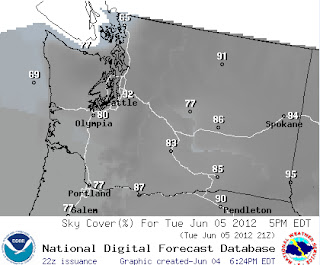
Here is the official National Weather Service sky cover percentages for 5 PM and 8 PM:
Tomorrow, from around 3:09 PM to sunset, Venus will move in front of the sun---the famous transit of Venus. This is an extraordinarily rare event that will not occur again for over a century (December 11, 2117).
The problem is that a weather system will pass through the region tomorrow morning and afternoon...but there appears to be a chance that some NW residents will see it.
Bottom line: for Puget Sound residents, head for the southern Washington coast or Oregon coast for maximum chances of viewing. Westport might be the closest location that is viable for Seattle residents. Or head south to Longview/Portland.
I don't have much time right now...but here are some of the model graphics, indicating cloud cover. First, cloud forecasts for 2, 5, and 8 PM.
Portland and northwest Oregon may luck out. There is some uncertainty with these forecasts...lets see what tonight's runs show.
Here is the official National Weather Service sky cover percentages for 5 PM and 8 PM:
Subscribe to:
Posts (Atom)
Pacific Windstorm Will Hit The Pacific Northwest Late Thursday and Friday
Autumn began yesterday at 5 PM and the atmosphere has taken notice. A significant midlatitude cyclone will cross the northern Oregon coast l...
-
For those worried about below-normal mountain snow, your worries are over..... a major snow dump is ahead. You can also expect great skiing,...
-
A number of you have asked about this coming winter and the status of La Niña. Will the snowpack continue to increase? Will those worried ...