It is hard to remember such an extended period in March where snow was falling somewhere over the lowlands of western Washington and Oregon. Even yesterday, the persistent snow plagued our region, with the area south of Portland and extending down to Eugene not only getting snow, but record-breaking snow. Eugene had a storm total of 7.5 inches...the most they ever had so late in the season.
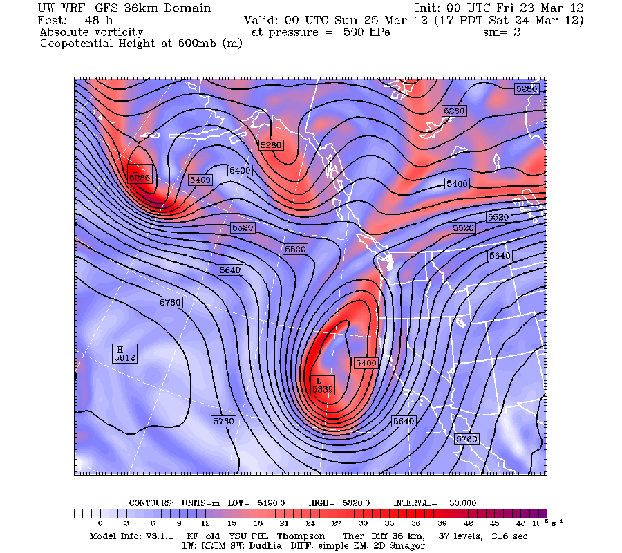
But I have good news...I think snow is over for the lowlands...and probably for the rest of the spring. The large scale atmospheric pattern is shifting enough that we should enjoy near normal temperatures for a while (like mid 50s) and believe it or not Saturday should be dry and perhaps a few showers over the western sections on Sunday morning.. During the next few days a deep trough will build in the eastern Pacific and all the weather will head south to California. Here are the upper level maps for Saturday and Sunday...not the best time to vacation in lotus land, but they will get acutely needed precipitation. We are left high and dry...and I mean dry, with a weak ridge extending over the NW. Saturday may get up near 60F.


I would contrast this with the weather in the Midwest. I heard this from a coworker today: Chicago had 8 straight days of 80+ degrees this month, after recording only 10 days that warm in March since 1871. I wonder, what is the probability of that many outliers, given natural variation?
ReplyDeleteThe cartoon with the caption "Then a miracle occurs" perfectly encapsulates "intelligent design".
ReplyDeleteI see today's high at SeaTac was 54... still one degree below normal. Took a hike with friends at Cougar Mountain and it felt like a balmy spring day because it's been below normal for so long.
ReplyDeleteThere's still patches of snow at Cougar Mtn. above about 1000 feet elevation.
Cliff, as I look at the UWashington radar at this moment (Saturday 9:30 A.M.) I see some serious red anomolies in the south Puget Sound...one of them is near my house but it's dry out. Do you know what these are?
ReplyDelete"I see some serious red anomolies in the south Puget Sound...one of them is near my house but it's dry out."
ReplyDeleteKATX is suffering from ground clutter problems today. Cause unknown but it could be either equipment issues or perhaps tropospheric ducting.
http://forecast.weather.gov/product.php?site=NWS&issuedby=atx&product=FTM
Message Date: Mar 24 2012 17:24:30 (UTC?)
THE KATX WSR-88D IS EXPERIENCING SEVERE CLUTTER SUPRESSION ISSUES. MOST RETURNS CURRENTLY SHOWING FROM KATX ARE NOT REAL. TECHINICIANS WERE CONTACTED EARLIER THIS MORNING ABOUT THESE ISSUES. WE DO NOT YET HAVE AN ESTIMATE WHEN THIS ISSUE WILL BE RESOLVED.