You don't need to be a meteorologist to know that we have been substantially cooler than normal the past five days--on both sides of the Cascades. Here is a sample from Seattle and Pasco. Roughly 5-10F below normal on the max temps.
The reason? A persistent trough over the Northwest, as shown by this upper level map (500 mb). You will notice that while we have a trough, the central/eastern U.S. has had ridging, and yes, their temperatures have been well above normal, a pattern we have
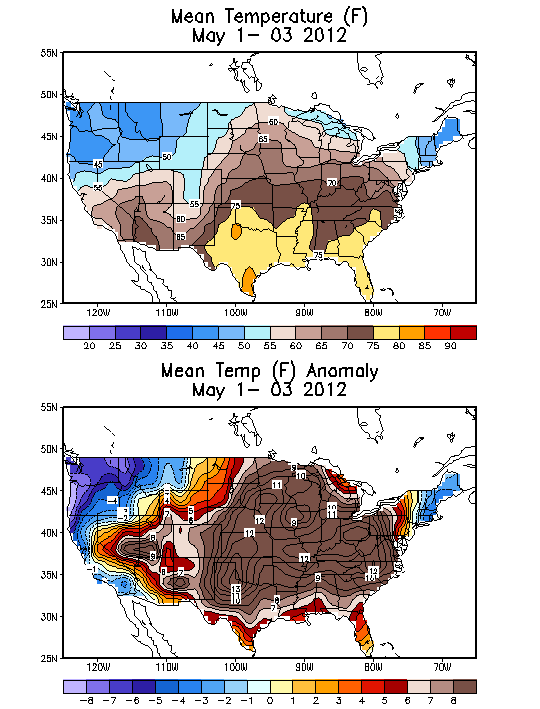
seen a lot of this spring. Here is the mean and anomaly (difference from normal) temperatures for the first three days of May. We are cold and purple--that seems appropriate, purple for cold, and that is the UW Husky color. The eastern U.S. is brown, with warm anomalies approaching 8F.
But this will change as ridging is now occurring aloft, as illustrated by the latest European Center upper air prediction for Sunday at 5 PM. This ridging will hold at least through Monday, so expect lots of sun and much warmer temperatures on Sunday and Monday--in fact, many of you will be in the 70s Monday afternoon.
Here are the latest UW WRF model forecasts for surface air temperatures (remember these are for 2-m above the surface). On Sunday, mid-60s on BOTH sides of the Cascades (except for NW WA and coastal residents near the water, sorry).
And 70s in that Willamette Valley, a natural hot box due to its isolation from the ocean influence.
But as good as Sunday will be Monday will be spectacular, with seventies extending to Seattle and the torrid Willamette Valley getting near 80F.
Finally, let me end by noting that we have had strong Puget Sound convergence zones over the past few days, with some being unusually broad. A few samples from the Camano Island radar for your amusement. The nice thing about such situations is that you know where to go to escape the rain.
Let me end with a reminder that I will be giving a talk in Portland (OMSI Science Museum) at 10 AM on Saturday on the future of NW weather prediction. More info to the right. I will bring a few books to sign as well.


Cliff, starting last week your blog was dropped from my Yahoo home page. I tried re-subscribing but no dice. I am able to subscribe to the comments update but not to the posts blog. Anyone else having this problem? Would'nt you know it...as soon as it starts to warm up we're heading to Sacramento for 2 weeks!
ReplyDeleteBill in Sequim
You lucky people! In the UK we have very unwelcome COLD conditions - for what is usually a sunny warm May there are cold northerlies, snow in northern England northwards through Scotland and frosts at night even in middle English areas. Mad. As in crazy, not annoyed. Weather is weather!
ReplyDelete