Take a look at the infrared satellite picture at 1 AM today (Wednesday)--you can see the the frontal cloud band stretch northward just offshore our coast towards Vancouver Island and then out to the west.

And the radar image from Langley Hill near Hoquiam showed a nice offshore precipitation band associated with the front.

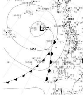
The official National Weather Service surface analysis indicates a low center and fronts offshore.
This system is rapidly falling apart and most of you won't see much more than a few sprinkles and lots of clouds. But it is serves as our first warning of the upcoming fall.
The return of precipitation this time of the year is quite evident in the daily climatology at Northwest weather stations. For example, here is a table produced by Mark Albright, past WA State Climatologist for the precipitation and other parameters at Seattle Tacoma Airport. The mean daily precipitation (next to last column) of .02 inches during the first 12 days of the month, nearly doubles around the 15th. More impressively, the frequency of measurable precipitation goes from 11-15% in the beginning of the month to roughly 25% at the end, with the big transition occurring between the 12th and 24th on average.

Don't get too depressed by this...summer is not over and we often have glorious Septembers. But changes in the Northern Hemisphere's weather pattern is now becoming evident and we are leaving the optimal period of warmth and dryness that is so dominant the last week of July and the first week of August.


Can anyone tell me why, when moisture slides up the backside of the Cascades, the east slope towns get big T-storms and massive precip, but now, with the moisture coming directly from the West off the sea, we get only light drizzle? It seems like the air is being brought in from the same ocean, with the same dew point, and the land on both sides of the mountains is quite warm... yet we don't get any convection. Why so much more CAPE for the Mazama folks? And where is the convergence zone effect?
ReplyDeleteHello, sir, love your blog. Would you be able to direct me to a site that might show current rainfall amounts to date for the area? I am an avid mushroom hunter, and would love to seek out those places that most benefited from those torrential thundershowers we had over the last few weeks. Thanks for the great info!
ReplyDelete