Showing posts sorted by relevance for query bird radar. Sort by date Show all posts

May 02, 2020

Forecasting Bird Migration with Weather Radar and Models

We are now in the midst of the big bird migration time of the year and weather radar can help documents the huge flux of birds overhead.

But even more fascinating, we can skillfully predict bird migration using numerical weather prediction.

One of my favorite sites  to check out bird migration is BirdCast, run by the Cornell Laboratory of Ornithology.  I really appreciate this group and as an undergrad at Cornell I frequently visited their Sapsucker Woods Wildlife Sanctuary.


One of the wonderful things they have on their website is real-time bird migration maps based on the clever use of weather radar (see below).  Turns out that weather radar is a very effective tool for tracking birds, particularly when there is not much precipitation (when the National Weather Radars are in clear air mode).

The map below provides an example:  a real-time snapshot of bird migration at 12:50 AM PDT early this (Saturday) morning.  The colors shows the intensity of bird migration and the orange arrows provide the direction of migration (which can be determined from the Doppler weather radar signal!).  Not surprisingly, most birds are moving northward and the Pacific Northwest is an active migration route.    The largest migration is from Texas to Wisconsin.  By the way, the units of this map is THOUSANDS of bird per km line per hour.   That is a lot of birds!


To confirm the bird invasion, here is the composite radar image the night before (1:38 AM on May 1st).  Wow.  There was very little precipitation that night, so virtually all of this is birds. Keep in mind that there are major gaps in weather coverage (such as east of the Cascade crest).   You note lack of echos offshore...our feathered friends prefer to stay over land!


Our bird friends prefer to fly at night, and the Cornell migration graphic at 9:40 PM Eastern Time yesterday shows this, with the red line indicating the location of sunset at that time.  Very few birds while the sun is up (west of the line), lots of birds to the east of the sunset line.


But this site has even more!  It include forecasts of bird migration activity.    Using decades of radar information to provide migration ground truth, they correlated bird migration activity with forecat weather parameters (from NWS prediction models), day of year, and much more, using a machine learning algorithm. This approach is based on the work of Van Doren and Horton (Science Magazine, 2018) . To illustrate, here is the migration prediction for tonight (Saturday-Sunday), which includes the amount of forecast precipitation as well.

Less birds tonight..and that has to do with the change in the weather.   This bird forecast research noted above (Van Doren and Horton) found the bird migration correlates best with temperature (more migration with warmer temperatures), with precipitation also discouraging our feathered friends.  The strong front moving through today will result in both cooler temperatures and showers.  Thus, our migrating bird visitors will take a well deserved rest this evening.

Finally, I should mention that there is all kinds of fascinating information in that Van Doren an Horton papers, such as the annual variation in bird migration over the U.S. based on the weather radar data (see below).  Peak migration is in early-May, with a huge ramp-up in April...so we are very near the peak now.  Thus, watching the radar now is of particular interest for all bird lovers.
So during the next mild night this month, look up and imagine the thousands of birds that are moving northward above your head.  Kind of reassuring during these difficult times.

September 08, 2013

Mega Bird Migration

It has been a hard time for migrating birds over the region.  

They don't like headwinds as they head south, and we have had persistent southerly (from the south) flow for weeks due to a persistent low off the coast (see image).  Hard going for the little fellows.

For over a week, the typical lower-atmospheric weather map (here shown at 850 hPa, around 5000 ft) had this configuration, with a low right off our coast, resulting in persistent southerly flow and showers.


They don't like rain, and particularly heavy showers, and I don't have to tell you about our recent thunderstorms!  I guess birds are a lot like people in that way.

But something magical for birds happened last night:   as the low moved through, the winds in the lower atmosphere turned to northerly (see image) and the skies cleared.  Optimal conditions for migration. And our bird friends were ready!


 Weather map at 850 hPa (roughly 5000 ft).  High pressure has built off the coast resulting in modest northerly flow over the western side of the Cascades.  Tail wind for birds going south.

Let me show you, using a variety of weather radars, this pulse of bird migration in action. 

The new Langley Hill coastal radar is a wonderful bird-watching tool.  When little precipitation is around, these radars are in a highly-sensitive mode that really shows the birds.  And remember, many migrating birds, particularly the smaller ones, like to fly at night when they are safer from predators.

Starting with the radar image (composite of all altitudes) at 7:49 PM Saturday night, we see a lot of ground-clutter returns (the lower radar beams hitting the surface mainly).

About an hour later (9:09 PM) and after sunset, things have really changed.  Lots of echoes and some very intense.  These are the birds.  Birds don't like to migrate offshore very far and you can see that in the echoes.

 12:22 PM the echo coverage has expanded.  Lots of birds on the move

 5:37 AM there are still some birds, but the numbers are dropping.

 And after sunrise at 6:39 AM, nearly all are gone and we are back to ground clutter
The Langley radar is a Doppler radar and it gives the velocity of the targets (in this case birds) towards or away from the radar.  Here is the Doppler image at 12:46 AM.   Green indicates approaching and red and orange going away.   Clearly the birds are heading south!

Now let me show you something interesting.   Here in Seattle we have a very special type of weather radar, called a radar-wind profiler, located at the NOAA facility at Sand Point.   Instead of sweeping horizontallly, this radar has three static beams, mostly facing upwards. This radar picks up birds as well.  Take a look at an image from this radar for the 24-h ending mid-day Sunday.  The y-axis is height in meters and time is on the x-axis (in Greenwich Mean Time (GMT, UTC), 06 is 11 PM, 12 is 5 AM, etc.).  Stronger returns are in purple, blue, and green.  The birds are obvious.  Around 03 UTC (8 PM) we we see the start of the bird echoes.  Lots of flying in the evening, which fades a bit in the middle of the night.  But you see a complete collapse after 5-6 AM as it starts getting light out.

It will be dry for the next several days, so expect to see a lot more migrating birds on the local radars.


May 16, 2010

There is a bird in my radar!

During the past few weeks, several of you have asked essentially the same question:

" It's been completely dry but the weather radar last night showed lots of echos, suggesting it rained all night. What is going on ?"

Well, I can give the you the answer: Birds!

Weather radar can see more than raindrops. It can see the mountains, but that signal is generally removed successfully (terrain clutter) since the mountains generally don't move. Weather radar can see other objects in the air and the amount of return generally increases by the sixth power of the object's diameter. (Doubling the size of an object increases the amount of the radar signal scattered back increases by 64 times). Since a bird is much bigger than a raindrop, you can imagine that it would provide a good return.

Another point. The weather radar used by the National Weather Service has two modes: clear-air and precipitation. Clear air mode is much more sensitive and is used when it is not precipitating to get some information on the winds. In this mode, discontinuities in the atmosphere (e.g., where density changes rapidly) and bugs (which get blown about by the wind) can show on the radar (within tens of km of the radar site) to provide some useful information.

But now we get to the birds. During dry periods the radar is on the hypersensitive clear air mode and during the night (particularly during migration periods in spring and fall) a whole lot of birds are up there. According to my birder friends and a few articles I have read on the subject, a number of birds (like songbirds) like to migrate at night, typically flying into the bottom 10,000 feet of the atmosphere. This time of the year they are flying north and in the autumn to the south. The amazing thing is this migration is really tied to the clock...after sunset, the radar is filled with echo, remains all night, and like magic disappears after sunrise. (Keep these numbers in mind: on May 15th, sunset was at 8:40 PM (3:40 UTC/GMT), sunrise was at 5:32 AM (12:32 UTC).

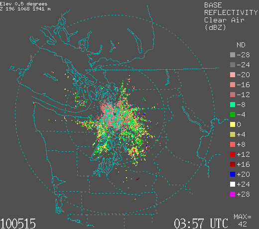
OK, you want to see if for yourself? Here is the radar (Camano Island) at 8:57 PM on May 14th, right after sunset. Not much echo, just ground clutter from terrain and some close in returns near the radar.


Here is the radar image less than an hour later, when it is starting to get dark 9:36 PM). Echo is starting to fill the domain. And it is NOT raining.

And here is the situation at 11:04 PM. Much of the domain visible by the radar has echo. The birds are everywhere!


At 5:06 AM the next day, there is lots of echo still:

But at 6:04 AM (remember sunrise was at 5:32 AM), the echo (and the birds) are mostly gone!


And at 8:02 AM, much less still:


Now want to see something neat? The NWS radar is a Doppler radar and thus can measure the speed of the targets towards or away from the radar. We can check out the velocities of the birds! Here is is:

Greens indicate velocities toward the radar (in knots) and yellows/oranges away. The radar location is in the middle. The birds are migrating north, roughly at 20 kts! (a relief...it would have been a problem if it had been the other way).

Ornithologists know about the value of the weather radar and use this technology to track migrations. Occasionally, there are weekend weather people on TV that make the mistake of misidentifying birds for precipitation...but you won't.

April 13, 2012

Bird Migration on the Coastal Radar

I have mentioned before that we often see birds at night when the radar is in clear-air mode--the highly sensitive setting that is used when there is not a lot of precipitation around.  In fact, there is a whole discipline centered around this tool:  radar ornithology.

Well, we have our new coastal radar and I was wondering how the birds look from a  coastal perspective and particularly whether our feathered friends like to fly offshore.  Lets get some answers!

Here is the composite radar image a little after sunset, when there was still plenty of light in the sky (8:33 PM, Thursday).  A few echos, with a lot of ground clutter around the radar (radar beam hitting the surface).


 One hour later, a lot of red/orange echoes--those are the birds.

 An hour later...even more birds.  Interestingly the birds don't seem to fly very far offshore (the few isolated echos you see over the Pacific are some light showers).  Perhaps someone can tell us why.


Still doubt they are birds?   Well, we can check the direction of motion using the Doppler radar capabilities of our radar, telling us the speed of the "targets" towards or away from the radar. Green indicates flow towards the radar and red away...and the velocities are quite substantial (up to around 30 kts).  The color indicates that these objects are moving northward..what we would expect from spring migration.  The birds had a tailwind last night (literally!) since there was southerly flow in the lower atmosphere.


 These bird echoes disappeared around sunrise....something that is clearly not meteorological.

The sun is long set tonight (Friday) and here is the latest radar image from Langley.  Same deal...lots of birds.   Note the appendage sticking out near Grays Harbor...that is sea clutter....the radar beam is hitting the ocean surface and reflected back to the radar.  There was some worry that our new radar might have a more serious sea clutter problem, but as you see it is a minor issue.


Tonight the winds are from the north aloft and the Doppler velocities are weaker but still indicate targets that are moving north (see image), but at a slower speed.  The reason:  tonight our feathered friends have a head wind slowing their progress!


If only birds could interpret weather radar imagery....

Preparing for tonight's migration

September 21, 2026

Peak Bird Migration Reveals Gaps In Northwest Weather Radar

We are now at the peak of the bird migration season, and weather radar does a good job of tracking our feathered friends. 

The massive bird swarms over us now are a powerful tool for determining gaps in weather radar coverage.


Let's examine the regional radar imagery in more detail.

As some background, here are some weather radar-based bird migration statistics (from the Cornell BirdCast website).  Birds like to fly from sunset to sunrise, with a peak around midnight/

And we are nearly at the peak time of the year for the southward migration. 

At 5 PM yesterday, the combined radar image showed was just some local ground clutter.


The situation was very different at 9 PM, with the birds in flight (below).  The birds don't like to fly offshore. 


But over land, there are clearly major radar gaps, such as the southern  Oregon Coast, larger areas of north-central Washington, and much of eastern Washington.

Similar story around 3 AM today.


And this morning at 8 AM, the bird signal is gone, with just some ground returns.


The current weather radar locations are shown below with blue dots.   

 Suggested locations for new radars are shown by the red circles. Additional radars would be very helpful for weather prediction and other uses (e.g., wildfire management, flood warnings, and more).


December 31, 2020

National Weather Service Weather Radar Disaster

There are few more important weather data sets collected by the National Weather Service than weather radar.


  • It shows where it is raining/snowing and how those areas are moving.
  • It tells us about severe weather, such as intense, rotating thunderstorms.
  • It even tells us about bird migration and how the winds are moving.

Critical, important information that saves lives and greatly improves weather prediction.  And information that allows us to stay dry and enjoy outdoor activities.

To give us this boon, the National Weather Service spent over 3.1 BILLION dollars to install 122 Doppler weather radars across the country (see below for the network).  They have spent hundreds of millions of dollars to maintain this complex system.


To view the weather radar data, one previously had a variety of options.  You could go to the National Weather Service web site, where there was a serviceable but degraded resolution interface (see below), visit university of private sector websites,  or you could purchase/acquire a radar app for your smartphone, which (to be honest) is what most professional meteorologists do.


But now the problem.

The clunky, but workable, old National Weather Service radar displays depended on Adobe Flash to work and Flash would no longer be supported after 2020.   So they came up with a replacement.  

And the replacement is a disaster--essentially non-functional.   It either fails to bring up the radar imagery or does it so slowly to be useless.   You can find it here: https://radar.weather.gov/#/  

Try loading it and animating an image (the key function that everyone needs).   You will immediately see the problem.


The negative reaction regarding this inoperative radar web site has been substantial, including an article in the Washington Post and a tsunami of negative comments in social media.

Software engineering has never been a strong suit of the National Weather Service and they have had problems on their online weather web sites for year and software issues have plagued their numerical weather prediction efforts for decades.   Even today, local National Weather Service offices lack sufficient communication bandwidth to secure all the high-resolution weather products they could use profitably.

Recently, the National Weather Service, crippled by lack of an ability to get data out to the national community, has started to restrict access to their servers, a move that could undermine the use of its model data by the private sector (including major weather companies like IBM/WeatherChannel, Accuweather, and others).

A key issue is that the National Weather Service insists on using early century data distribution technology, using their own servers for national distribution of large data sets.

The solution to the National Weather Service data problem is obvious, particularly to the technologically inclined among this blog's readers: make use of cloud distribution of the weather radar and other large data sets.

It turns out that the National Weather Service is ALREADY moving the FULL weather radar data set in REAL TIME to Amazon Cloud Services. The radar data is already there (see below, NEXRAD is the radar data).


So instead of distributing radar data through their own servers, the National Weather Service should have their radar web site hosted in the "cloud", where the data is already resident.  

A modern approach that would afford essentially instantaneous access to the vast NWS radar data set.  The same is true of the other important data sets created by the National Weather Service (such as forecast model and weather satellite information).

So for those of you looking for weather radar data, what can you do?


Or if you want national radar information, try out the NOAA/NWS Aviation Center radar site.

Another possibility is the College of DuPage radar site.

For me, a good weather radar app is the key and the one I used is Radarscope (see below).   Inexpensive and very easy to use, and available for both Android and iPhone.  Plus you get access to the most high-resolution data.


The deeper question, of course, is how National Weather Service management missed such an obvious failure mode and why the National Weather Service software engineering and modeling has been allowed to fall well behind the state-of-the-art.  

Perhaps it is time for a private sector Weather-X.  But that should be a subject of another blog.

_________________

I will do a new weather podcast tomorrow!  The New Year forecast, plus I will explain, why there are wind gusts.


March 17, 2023

Massive Migration Occurring Aloft and Even Warmer on Saturday

 This is the season for northward bird migration and the weather is now perfect for northward flight.

As a result, there is a massive northward movement of birds occurring and the weather radars are lighting up with birds each night.

As I noted in previous blogs, many birds prefer to fly at night, so let me show you the regional radar imagery over the past 24 h.

5 PM yesterday (Thursday) there was nothing


At 2 AM, bird returns were everywhere with radar coverage.  Notice our birdy friends don't like to fly offshore.   You can also see where we lack low-level radar coverage, like the central and southern Oregon coast and eastern Oregon.  Oregon bird watchers need to complain!


This morning at 8 AM, the birds are gone.


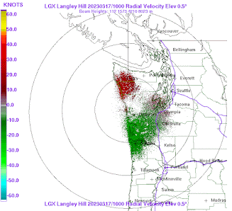
I rarely show Dopper radar imagery (which shows winds towards or away from the radar), but here is last night's image from the Langley Hill radar in Hoquiam (the radar is in the center of the circles).  Green indicates the targets (birds) are approaching the radar, red shows targets moving away.

The radar targets are going northward!


There is a nice website Birdcast, which collects all the radar information and shows migration patterns over the US.  Here is theeir graphic from last night, with arrows showing the direction of migration.  A large northward movement of birds along the West Coast.


I have noted that birds are a bit picky about nighttime flying weather.

They don't like heavy rain and stormy periods.  They also appear to appreciate a tailwind.  

And last night they had one.    Below are the winds overnight at 700 hPa (about 10,000 ft).  The little barbs show the direction and speed.  Southerly and southwesterly flow (from the south to the southwest) was apparent.  Not too strong.  Just like our feathered friends prefer.


Heatwave

    Today will get near 60F in western Washington and some places will get into the lower 60s on Saturday.  Take a look at the forecast surface air temperatures on Saturday at 5 PM (below).  Red is warmer than green and blue.  Wow.  Lower 60s all over the place in the western interior.


Warm southerly (from the south) winds aloft plus low-level downslope (easterly) winds over the Cascades are the reasons for the warmth.  This will be the warmest period since last October (see plot below, with 60F highlighted).  And it will feel good.


Have a good St. Patrick's Day.


Good News for West Coast Water Resources

With all the worry about the current Super-El Niño, it is comforting to see the substantial snow and precipitation of the past week, with fo...