October 31, 2010

Will Weather Influence Tuesday's Election?


Is it possible that weather could influence the outcome of Tuesday's midterm election? If so, can we make any predictions based on current weather forecasts?

The general wisdom is that bad weather favors the Republicans since supposedly some key Democratic voting blocks (e.g., the elderly) are more weather sensitive than the rest of the population. Republicans are supposedly less influenced by rain for reasons that escape me.

It turns out that the academic literature is very thin on this topic and I could only find one refereed article in the Journal of Politics by Gomez, Hansford and Krause ("The Republicans Should Pray for Rain: Weather, Turnout, and Voting in U.S. Presidential Elections"

According to this paper, which examined turnout in 14 presidential elections using 22,000 weather stations, there ARE statistically significant results:

Heavy rain reduces voter turnout by roughly 1% for every inch of rain above normal. Snow reduces turnout by .5% per inch. Furthermore, Republican presidential candidates gain 2.5% of the vote for every inch of rain above normal, and .6% for every inch of snow.

Now an inch of rain is quite a bit of precipitation, only occurring during major storms (like Monday in the NW) or in thunderstorm areas.

Furthermore, these results were for presidential elections where people are generally highly engaged and motivated. What about midterm elections like Tuesday's? If we assume that people would be less excited than for presidential runs would one expect the influence of precipitation to be greater for this election?

And what about the influence of the greater proportion of absentee ballots and of extended balloting times (some places in the U.S. allow voting in the weeks before the election)?

These are serious and weighty questions.

So lets play politics.

Here is the forecast precipitation for 12-h on Tuesday ending at 5 PM PDT (8 AM PDT). Most of the U.S. will be rain free (good for Democrats) and the only area with serious rain is in the southeast (eastern Texas, Louisiana, and Mississippi). No serious snow across the lower 48 states.

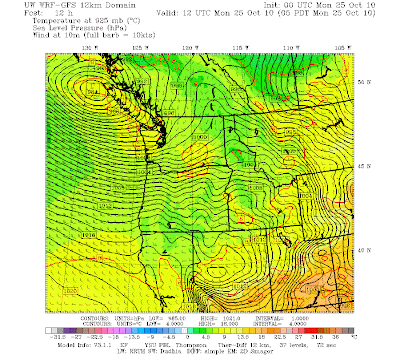
Are there any close races that could be turned? Here is a map by political expert Karl Rove on the U.S. Senate races. It appears that there are no senatorial races that are close in the rain areas--there is either no race or they are heavily Republican. Here are Tuesday's temperatures across the lower-48: mild conditions are expected.


Thus, Patty Murray will be favored by better weather than expected on Tuesday, since the heavy rains of Monday will be over by then--thus people will be more likely to mail those last-minute ballots (only Pierce County still has polling stations here in Washington State). Might she be saved by the rapid movement of tomorrow's pineapple express?

The same picture is generally true for the House races, the rain will be mainly over Republican strongholds.

If the conventional wisdom has any basis or if the the Gomez study is applicable, the the weather forecasts are generally favorable for the Democrats, although the impact will probably be small. But as Gomez et al state, some close races HAVE been determined by weather.

October 30, 2010

Less Flooding Risks

The trend of the computer models is to produce less rain over the Olympics and North Cascades--mainly due to the fact that the band of strong, moist flow will be moving through the area more quickly than forecast a few days ago. Here is the latest computer model forecast (24h precipitation ending 5 AM on Tuesday)--2 to 5 inches over the Olympics. This is enough to flood the Skokomish, and perhaps a few other river, but not the serious threat of earlier runs. The north Cascades also is getting less of a hit, so the Skagit and Stillaguamish will probably remain in their banks.


The advertised storm in the Pacific has developed rapidly...you can see from the satellite picture below that is huge an intense. The center of the low is in the middle of the swirling clouds. The times the clouds circle around the low, the deeper the storm in general. Still expecting 40-50 ft waves in the Gulf of Alaska from this monster.


Here is the latest Pacific analysis for nearly the same time. 939 mb low...that is really deep.

Sunday should actually be a pretty good day around here, especially after the current front moves by. You can see both this front and the relatively cloud-free area just offshore in the above satellite picture.

October 29, 2010

Update

The heavy rains are still on track for Monday and early Tuesday for the Olympics and North Cascades, although the current runs are not quite as extreme.

The intense storm in the Gulf of Alaska is now forming--here is the wind field over the Pacific for 11 PM tomorrow. Just amazing. The white areas are higher than 55 kts sustained winds....essentially hurricane force. This IS a hurricane...but a midlatitude one. And keep in mind that strong winds, a long-lasting storm, and large fetch produce big waves.

And yes, the waves are forecast to be enormous...here is the prediction from the NOAA Wavewatch 3 model. The pinks are waves greater than 15 meters (49 feet). These waves are NOT heading here.

On Monday a strong current of warm, moist air will be heading right into us..at 5000 ft the winds are forecast to be 50 kts and 50F from the southwest. Here is the latest rainfall forecast for the 24 h ending 5 AM on Tuesday. Not quite as extreme as last night's prediction with only a small area with more than five inches. Still plenty to bring some of the rivers of the Olympics to flood stage. And one has to watch some of the North Cascade rivers like the Skagit and Stillaguamish..if you are near either of these I would be prepared. The National Weather Service is now putting out hydrological statements outlining some of the threats noted above.

One final note...snow melt might add to the available water. We had quite a bit of snow earlier this week above 3500 ft and a lot of that is going to be melting very fast on Monday.

October 28, 2010

Major Rain and Flooding Event Approaching

Well, I was having some fun in my last blog, but this one will be serious. The reason? A major rain and potential flooding event may be coming, one that could impact some people's lives. But some uncertainty remains, and I will try to be upfront with that as well.

During the next few days a disturbance off of Asia (Typhoon Chaba) will move northward, turn into a midlatitude cyclone and amplify into an extraordinarily deep low pressure center (see graphic). We are talking about 939 mb! (compare that to the 955 mb over the Midwest that everyone was excited about two days ago). There are so many isobars near that low the graphic is turning black!

The monster storm, huge in scale and possessing hurricane force winds, will produce giant waves--greater than 50 ft high. I could fill an entire blog about this storm...but there is a more acute worry here at home.

As the low pushes into the Gulf of Alaska it will result in the establishment of a very strong, moist current heading right for our region. You know the names---atmospheric river is the generic term and our version is often called a pineapple express. The next graphic presents the early stages of this feature (Monday AM)....the total amount of water vapor in a vertical column is being shown:


You can see the current of moist air heading right for us.

Here is the 24-h rainfall prediction ending at 5 AM Tuesday. Red indicates 5-10 inches of precipitation over the Olympics, north Cascades, and mountains of southern BC. Precip decreases rapidly to the south.


A looks at a closer view for the same period below. A profound rainshadow will also exist NE of the Olympics. I am sure the National Weather Service will be putting out some statements on potential flooding of rivers coming off the Olympics and N. Cascades. At this point it does not look like a situation that would produce urban flooding over the Puget Sound population areas.

The plume of atmospheric river air over us on Monday and Tuesday will feel warm, moist....almost tropical after the cold weather. Freezing levels will rise to 8-10,0000 ft and a lot of the new snow will melt (sorry snow lovers).

I should be clear that there is often a lot of uncertainty with these cases of tropical storms converting into midlatitude systems. But the computer models have really locked on to this solution and we are close enough now in time that I am believing it. Lets face it, it is really extraordinary we can do this at all.

October 26, 2010

Media claims are wrong. WE have the record storms!

In this fight, we have right on our side

There has been a lot of media attention regarding the storm in the Midwest with claims it was the strongest (lowest pressure) non-tropical storm in U.S history. DON'T BELIEVE IT FOR A MOMENT. This is classic eastern U.S. media myopia....we have had the deepest and most violent storms!

So here is the story. The media is raving about this storm in the Midwest in which the lowest pressure reported was 28.20 inches or 954.8 mb at Bigfork Airport in Minnesota. This is the lowest pressure ever observed in Minnesota! Here is a surface analysis of the storm at its height.


Now this storm has very low pressure but the pressure gradients (pressure changes with distance) are not that impressive and pressure gradient drive winds. Thus, the winds were really not that exceptional.

But we can top that without breaking a sweat. Now take a relatively recent storm around here: December 12, 1995. During that event the sea level pressure at Buoy 46041 , 52 miles west of Aberdeen, WA got to 28.31 inches (958.8 mb) and certainly that did not sample the center of the storm. Since the storm was farther offshore the pressure would to had to have been considerabley less. The estimate of local storm uber-expert Wolf Read was the pressure had dropped at least to 953 mb (see track map below).


There are other examples I could cite. The great January 1880 storm was probably much deeper as well and I bet I could find others. In fact, David Ludlum's Weather Record Book, published by Weatherwise in 1971, reported 28.20 inches /954.96 mb at Reedsport, OR, on January 9, 1880.

And I haven't even mentioned the Columbus Day Storm of 1962, which clearly was the most powerful extratropical cyclone during the past century. Furthermore, our storms generally have larger pressure gradients and thus more extreme winds.

The media is going nuts about a storm that had maximum gusts of 81 mph. Big deal. Our storms regularly have winds over 100 mph and sometimes over 125 mph

If you want to read detailed accounts of major NW windstorms, check out the WONDERFUL web pages created by Wolf Read available on the Washington State Climatologist website:
http://www.climate.washington.edu/stormking/

Hours of good reading there.

And Bri Dotson and I recently published a paper on our storms--found at:
http://journals.ametsoc.org/doi/abs/10.1175/2010MWR3213.1

Now I know how these tricky east-coasters work. They will say that our storms are generally over water during their early lives and don't count. Don't let them get away with this. Their fabled "Nor'Easters" --which they count--spend plenty of time of water. And don't forget the Great Lakes! And why did they call one of their storms "The Perfect Storm" when many of ours far outrank it by any mark?

October 25, 2010

TV Special On Doppler Radar and AMS Meeting

Two things to mention and then some weather.

Tomorrow night (Tuesday) KIRO TV (channel 7) at 7 PM will broadcast a special titled "Winter's Warning" that will talk about the upcoming La Nina winter and more importantly will tell you about the new coastal radar. They went to Oklahoma to see an operational radar like the one we will get...with the special dual-pol option. In a year, you will all know what "dual pol" is!

And on Wednesday night at 7 PM there sill be a meeting of the Puget Sound Chapter of the American Meteorological Society here is Seattle, where we will hear about where the oil in the Gulf went (see info to the right). Location: NOAA Sand Point (7600 Sand Point Way).

And here is the picture of the day. There was quite a rainshadow in the lee of the Olympics...but it was centered over Seattle and the folks in Sequim got rain! Serves them right.

The reason? The winds approaching the coast in the lower atmosphere were from the west-southwest instead of the more normal southwest or south-southwest, causing the rainshadow to rotate towards us. The rainshadow moves with the large scale wind field.

October 24, 2010

Giant Waves


This is really turning into an extraordinary event. I can't remember over many years seeing this situation...a very deep system, slowly dying, that is sitting right off our coast for days. The models are having a very hard time with this storm as well.

Today a batch of very unstable air rotated around the low, bring lines of strong convection with heavy rain. With the low sitting out there and the strong winds remaining over the offshore waters, the waves have gotten huge. To show this, here are the significant wave heights (average of the top 1/3) for Buoy 46005, located at 130W off our coast. Update 8 AM Monday....40-45 feet!


Here are the sea level pressure forecasts starting at 5 PM tonight through 5 PM tomorrow. As the low moves eastward, the north-south pressure differences will increase and the winds over Puget Sound should crank up. And big waves will be striking our coast--right now they are 25-30 feet and they will get higher.

Here is a great web site showing coastal cams and providing a wonderful interface to buoy and coastal reports:

http://www.surfwa.org/Surf-Report-WA-OR-BC.html


And finally the rain. A few of you complained that the rain was a disappointment. But check out the 48-h rainfall total from Seattle rainwatch below. A band of 1-2 inches across the Sound with some places near the Olympics getting 3-4 inches. An an amazing rain shadow NW of the Olympics...nearly dry there. Want HUGE rainfall...head to northern CA...bet that will be on the news tomorrow.

October 23, 2010

The Storm

Its here.... A beautiful looking storm in the infrared and water vapor satellite imagery (first and second images below). The dark color in the water vapor satellite imagery indicates dry air descending into the low, a sign of strength.


Here is a the short-term forecast for 11 PM tonight...an impressive 966 mb low! There are a lot of isobars and very large pressure variations that produce strong winds over the Pacific Ocean.

As forecast the winds have really accelerated offshore and along the coast, with sustained 30-40 mph, with gusts of 50-60 mph. Here are the maximum gusts at Destruction Island...right off the WA coast...gust to 54 kts-- 62 mph. Lots of wind gusts above 50 mph over the ocean. The waves are increasing rapidly...now approaching 20 ft seas offshore--and they will rise further.


Right now the winds are climbing over NW Washington (Strait of Georgia and eastern Strait)--here is the sustained wind forecasts for 1 AM (30-35 mph with higher gusts)


The Smith Is reporting station died, but here is from buoy 48088 at the eastern entrance to the Strait of Juan de Fuca. Peak gusts are at 35 kts and rising.


But this is NOT going to be a major wind event in Seattle...even though some TV stations (unnamed ) are talking about it.

And of course it is WET outside,with steady rain over the region...here is the latest radar--green is moderate rain, yellow is heavy. A very nice rainshadow NE of the Olympics.

The heavy rain should be done by sunrise, with showers tomorrow.

Computer models are having a hard time deciding where the low is going--we will see.

October 22, 2010

Meteorological Earmarks and the U.S. Senate Race in Washington


There has been a lot of talk in the U.S. Senate race in Washington State about earmarks, and I thought I might give my perspective based on some actual experience with them.
Patty Murray (Democrat)

If you had asked me a few years, I would have been against them, but my mind has changed, based partly on my experience with the coastal radar. I now believe that earmarks are a useful tool, if used sparingly and with judgment.

Dino Rossi (Republican)

Consider the coastal radar that will be installed next September on the central Washington coast. Without earmarks this extraordinarily important device, one that will save lives and greatly enhance our lives, would not have happened.

A classic argument against earmarks is that all appropriations should go through the normal process, with budget requests from agencies vetted by congressional committees. Sound good. But for over a decade many of us tried to go this route in pushing for the coastal radar. The case was compelling but some folks in the National Weather Service opposed it and letters from Congressmen and Senators fell on deaf ears.

Nothing happened until the big storm in December 2007, after which Senator Maria Cantwell took a personal interest in the project after listening to her constituents in coastal Washington. Senator Maria Cantwell

Subsequently, with the aid of Senator Murray, Senator Cantwell was able to secure an EARMARK for the first two million dollars for the radar acquisition. And the rest is history. Next September we will be able to see, for the first time, the structure of approaching weather systems from off the Pacific. The folks in Gray's Harbor County and surrounding areas will be able to plan their lives with the guidance of the radar. Fishers and marine interests will have the protection of the radar while they do their work. And this would not have have occurred without the intervention of our U.S. Senators.

My conclusion. Washington D.C. bureaucracies sometimes don't have a good understanding what is happening and needed out in the field, in communities hundreds or thousands of miles away. Our Senators and Congressmen/women have an intimate acquaintance with their area and know where the acute needs that slipped through the cracks. Therefore, we need earmarks.

Yes, I know there have been some abuses and some earmarks have been problematic. But my reading through the earmark lists suggests that the majority of them are well-intentioned attempts to fix problems or to deal with issues that the government bureaucracy missed.

It seems entirely appropriate that a few percent of the U.S. budget should go to earmarks. Perhaps there are reforms that could make this fairer, such as insuring that all states get an equal shot based on their populations, irrespective of whether their congressional folks are well positioned on critical committees or in leadership positions. But a flat rejection of earmarks does not seem reasonable and from my perspective earmarks were absolutely critical in securing a critically needed piece of meteorological hardware for our state.

Forecast Update: The Sunday storm looks similar to what we expect last night. Strong winds over the ocean and right along the coast. Not much over Puget Sound during the day on Sunday, but it will blow to the north of the Strait of Georgia and the eastern Strait of Juan de Fuca.

UW Dawg Dash:

At 9:30 AM on Sunday the UW Dawg Dash will take place (fun run to support scholarships and other good works) and I have been asked to be the official starter (http://www.promotionevents.com/dawgdash/) I believe the idea is that a meteorologist might placate the rain gods with some sort of professional incantation. At this point I have been unsuccessful--the latest model runs show showers that morning around that time. Perhaps some incense will help.


October 21, 2010

Major Coastal Storm and Big Waves


It is become increasingly clear that our offshore waters will be hit by a very powerful low pressure center (what we call and extratropical cyclone in the business). The result will be hurricane-force gusts over the eastern Pacific and 30-40 ft waves striking our coastline. The interior should be generally spared with one exception: Northwest Washington and the Strait of Georgia, which will get 20-45 kt winds.

In reality there will be three major weather events:

The first is the weak system moving through right now....a bit of rain and windy offshore, but nothing major.

The second is a stronger, somewhat wetter system on Saturday morning.

But the real McCoy is on Sunday morning--a deep low offshore, with a very wet front moving through Sunday morning.

Lets cut to the chase. Here is surface charts for Sunday at 2 PM:


This is a 961 mb low..quite deep. However, the last few runs have taken it farther offshore--which makes it less of a threat for western Washington and Oregon. Here is a closer in view at the same time. Lots of isobars (lines of constant pressure), which results in strong winds offshore.


Here are the model surface (10 meter above the surface) winds at the same time. Offshore there are sustained winds of 45 knots and the gusts would be much stronger. Actually, the strongest winds on the coast will be late on Saturday, when the associated occluded front moves in (see figure). Sustained winds on the coast could hit 45 knots with higher gusts. Great weather for storm watching.!

These strong offshore winds will raise the sea and wave reaching 30-40 ft will move towards the coast. Here is the output from the NOAA Wavewatch III model, which predicts wave heights using the forcing from the atmopsheric models.

If this storm was a few hundred miles east of its predicted position we would be talking about a major damaging even and the weather channel would be flying in one of their storm folks....but fortunately that won't happen (if the models are right). I should note a rule of thumb of local meteorologists: to get strong winds over Puget Sound and the southern interior the low pressure center must cross the coast south of central Vancouver Island (my book has more on this).

Want to see the storms lined up on the satellite imagery? The first frontal band is on us. The comma-shaped system offshore is Saturday morning, and the huge, pregnant cloud mass farther offshore..THAT is the big one.

October 20, 2010

I don't believe anything yet...but


I don't want to get anyone excited
.

And because of Typhoon Megi there is a loss of predictability over the Pacific. So the chances are it won't happen.

But with all of that said...look at the latest forecast for Sunday morning at 8 AM!

An extraordinarily deep low center just off Vancouver Island. 964 mb! And each model run brings the storm closer!

And look at the winds offshore in the next plot. Sustained winds offshore of 55 knots and more and certainly hurricane-strength gusts!


It could all disappear in the next run. But if it is still there in tomorrow night's forecasts, I would get excited. At this point we are only talking about very strong winds over the Pacific and the coast and strong winds over the Strait of Georgia. Not Puget Sound and south.

Want Warmth? Take a Hike!

Last night was a classic fall example of the development of a lower atmosphere inversion (temperature increasing with height). Here are the temperatures above Seattle during the past six hours (from the Seattle profiler at Sand Point, heights are in meters, temperature in C). BIG INVERSION! Temperatures increase by rougly 10 C (19F) between the surface and 800 m (2600 ft). That is roughly the height of Tiger Mountain in Issaquah. We are talking 64F at the top of Tiger Mountain and the forties at the trail head!

As I have explained in the past, these inversion are associated with clear conditions during most of the night, allowing infrared radiational cooling to space from the surface. Eventually the surface cools enough so that fog forms and at low levels there is some fog around the region...but you could rapidly hike above it. And you wouldn't have to hike very high. Here is a cam shot at the Summit in Bellevue at roughly 1200 ft (thanks to Peter Benda) where you can see some fog at low levels.

The sun will burn off the fog today and the inversion will be lost as the surface heats and warms the air adjacent to it.

The weather forecasts for this weekend are rapidly shifting, but a downhill plunge is certain.

October 18, 2010

Major Change to Stormy Conditions Ahead

I generally like to wait until I am sure about things before advertising a major change and now I am. The models are all going for a major shift to stormy and wet weather this weekend.

But don't worry...we have a few more days of sun and warmth ahead!

Three days--with sunny afternoons, highs in the lower 60s, and dry...but with fog in the morning. Yes, it is fog season and you get the fog because of the clear skies (clear skies allow radiational cooling to space).

The source of our beautiful weather....a high amplitude ridge of high pressure over us (see the examples for tomorrow and Wednesday below). But then something is going to happen...and you can see a sign of it in the second upper air chart...a trough will be moving in later in the week and in force over the weekend.


In contrast, here is the upper level chart for 11 PM on Friday. No more ridge. A strong trough offshore and a very strong jet stream heading right towards us in the Pacific (note the winds are parallel to the lines and the greater the number of lines, the stronger the winds).


And here is the 24- precipitation ending 5 AM on Saturday. Wet!

On Saturday there will be showers and then another system on Sunday! And lots of winds over the eastern Pacific. More later...

Big Waves in Hawaii. Why?

 There is a lot of excitement in Hawaii today, as large waves from the northwest reach the north coast of Oahu, making possible the  Eddie A...