Today (Tuesday) brings Seattle to 44 days without rain. Impressive!
Tomorrow will be dry, allowing us to tie the second longest dry-spell (45 days), and we will certainly beat it, with dry conditions guaranteed through Saturday (48 days!)
But will we beat the all time record---51 days-- which we will tie on Tuesday (Sept. 11th) if it doesn't rain?
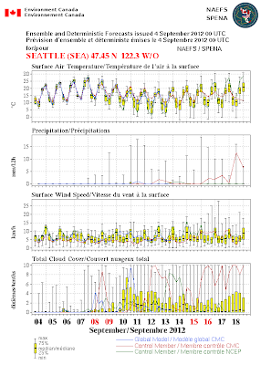
Folks...it is going to be close. Lets start with one of the best long-range forecasting tools, the output from the North American ensemble forecasting system, in which many forecasts are considered. Consider the second panel down. The bracket shows the range of the forecasts and the colored lines show two particular forecasts--the single forecasts used in most weather forecasts (the control members). The bracket show that some members are going for rain on the 10th and 11th, with one control member giving measurable precipitation.
This increase in precipitation threat is associated with a trough passing by just to our north. Here is the upper-level (500 hPa) map for Sunday at 5 PM that illustrates this.
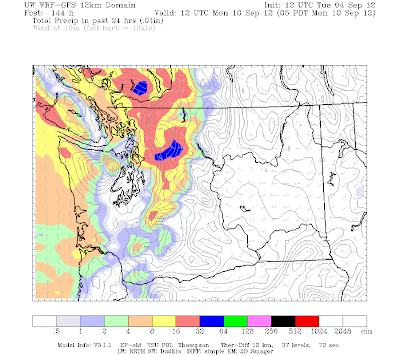
Take a look at the 24 hr precipitation forecast from the UW WRF system for the period ending 5 AM on Monday. Precipitation in the area, but Sea-Tac looks like it is rain shadowed by the Olympics. VERY, VERY close.
And the precipitation for the next 24-h is negligible:
Who says meteorology isn't exciting? I bet the Weather Channel sends Jim Cantore here to cover it. And I expect KING-TV's Jim Forman to be stationed at the airport all day looking for the rain (perhaps without his famous parka).
This is going to be closer than the Presidential election. You will tell your grandchildren that you lived through this.
For those interested in going to the Columbus Day Storm gathering on Oct 11th, you need to register...see information on upper right of this blog.
This blog discusses current weather, weather prediction, climate issues, and current events
Subscribe to:
Post Comments (Atom)
California and Oregon Are Getting Our Rain: But That is OK
There is always a yin and a yang in the weather. Because of the structure and limited extent of weather systems, one area's precipitati...

-
Today may be the last day you will need air conditioning this summer in western Washington. And fears of wildfires west of the Cascade cres...
-
Over the eastern U.S., the passage of a strong cold front, with a rapid decline of surface temperature, is a frequent winter treat. In contr...


Hmm, this is exciting! However in the 5 years I have lived in the Seattle, I have learned that if rain is possibly in the forecast then it will most likely rain (and more than was predicted). We will see. It sure has been a nice Summer for the last month or so.
ReplyDeleteCan we expect Jim 'Danger' Forman on the 5:00 news sporting his bright yellow sun bonnet? ;^}
ReplyDeleteFor a follower of your blog from the dry Eastern two thirds of the "Evergreen State", I find this RECORD DRY STREAK watch kind of humorous. We go months on end sometimes with the only discernible precipitation coming from drifting water droplets off the neighbors center pivot irrigation.
ReplyDeleteBut I am enjoying the drama of it all. I hope you set a new record in the city of my birth. As your first poster wrote, "It sure has been a nice Summer for the last month or so."
Enjoy the dry spell. I would take your rainfall over here anytime it wants to fall from the unpredictable sky.
Curse that Cascade Mountain Range!