Here are the highs over western Washington yesterday. Mid-90s in central Puget Sound, extending down the I5 corridor to Vancouver, WA. With easterly flow, even the coast was warm as were valleys in the Cascades.

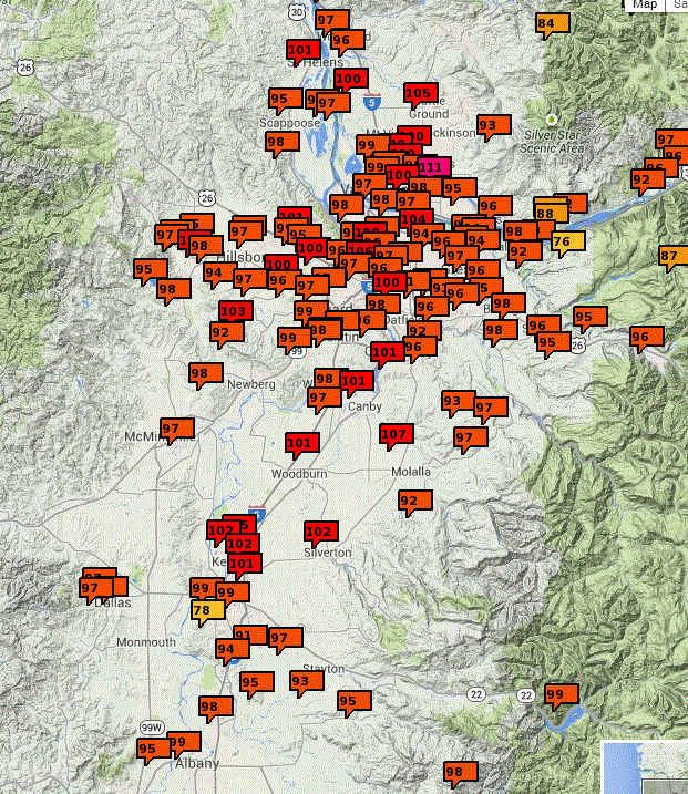
But if you really like heat, the Willamette Valley was torrid. A number of locations near and south of Portland reached well over 100F!

Here is a blow up of the max temps near and south of Portland. Crazy warm from Salem to south Portland. Lots of 102s and 103s.
Tomorrow will be much cooler. Already the pressure gradients are reversing, so that the marine air will flow in overnight. 80F should be a typical high tomorrow over western WA.
Visibility was extraordinary today, as it often is when we have offshore flow and no wildfires. And there was a spectacular cloud show todayy. Here are two pictures sent to me by Tony Nahra of fallsteaks: ice crystals falling out of some mid-tropospheric convection. These fallstreaks are curved because of the change of wind with height.


Man, I miss Puget Sound summers. Should I be fortunate enough to live there again, I will never complain during the "heat waves".
ReplyDelete-Tim in Houston
Noticed the clouds yesterday about 1p.m. They were spectacular! A couple were colored vivid red/yellow. Any idea what conditions caused this? Have never seen this before when not connected to either a sunrise/sunset or rainbow.
ReplyDelete