This morning, conditions produced TWO convergence zones at the the same time, one extending southeast of the Olympics, the other Vancouver Island. Pretty dramatic stuff. Here are two radar images to illustrate (thanks to Andrew MacMillen for pointing this out).
First, a regional view from the Camano Island radar at 4:44 AM. Two bands are clearly evident.
And a close up view at 4:53 AM with terrain. Amazing image. The northern line forms downstream of Vancouver Island, with precipitation become quite intense from Port Townsend to Lynnwood. The second line, downstream of the Olympics, is weaker and reaches across Seattle.
As with many convergence zones, precipitation extends into the western slopes of the Cascades. In fact, Steven's Pass ski area got a piece of this, with their base snow increasing to nearly 40 inches (FINALLY!). I hear their upper lot is already full.
Convergence zone precipitation is enhanced when air is unstable at low levels, often when cold air passes over the relatively warm water of the Pacific. The convergence zones have dissipated now, but the 10 AM visible satellite picture shows the instability clouds off the coast--you can even see their NW-SE orientation, which is parallel to the low-level wind.
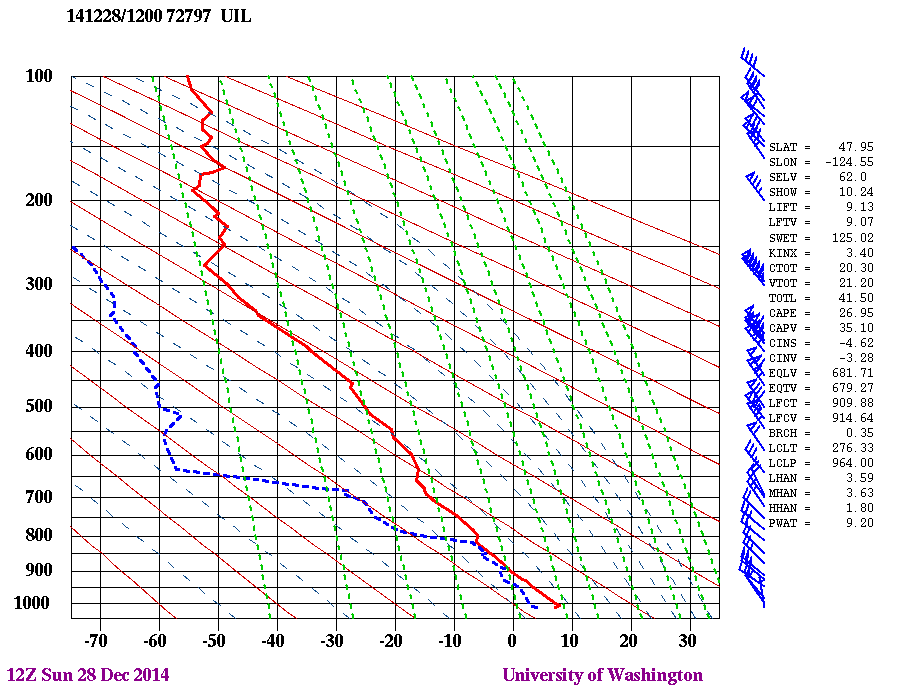
A radiosonde sounding on the Washington coast at Quillayute shows the strong northwesterly winds that approached the coast during the double convergence zone (height in pressure is on the y axis, with 500 about 18,000 ft.). This plot also shows temperature (read) and dew point (blue dashed) with height. A moist lower layer near the ocean (temp and dew point are nearly the same) and dry air aloft.
Strong northwesterly flow tends is favorable for producing a convergence zone extending downstream of Vancouver Island, since the island is oriented this way. The more circular Olympic mountains allows convergence zones from a greater variety of directions.
And forget about convergence zone or any other precipitation the next few days, as a ridge of high pressure builds over Washington. Enjoy the sun. A special New Year's gift for us.


Tuesday morning barometric pressure is spiking. Did the 1921 record stand?
ReplyDeleteSeaTac at about 10-11 AM peaked at 1045.4 Millibars breaking the previous record from 2011. I guess that's official enough!
DeleteCliff,
ReplyDeleteThanks again for your thoughtful efforts to educate those of us out here interested in the world around us.
I am currently seeing a weather pattern I've never noticed before. At Tumwater (Olympia) airport, every single night in the current five day forecast predicts a quite noticeable pulse in hourly temperature, at precisely identical times every single night, like clockwork(!) The start time is always midnight, pulse peak is always predicted to be at 5am, and the midnight min, temp is always repeated at 8am, exactly.
Tonight, the 5:00 pulse is +4 degF, the next two nights 3, and next two nights 2 deg. So far, I can't imagine a hypothesis which originates with any physics I know.
Have you got any ideas about what's happening here? Of course, I am not asking you for a personal reply, rather I was thinking that there was some possibility of this becoming a blog topic.
Again, thank you, thank you, for the work you put into this blog. In the off chance that you did wish to make some reply, I'm BobSpafford@gmail.com
Faithful reader bob
This comment has been removed by the author.
ReplyDelete