Bellingham
Seattle
The source of June Gloom is the large pool of low clouds that develop over the eastern Pacific. Here is the image this morning....the eastern Pacific is FULL of low clouds. Strangely enough, such extensive clouds occur under high pressure conditions, which develop as the East Pacific high builds and extends northward.
Why does high pressure help low clouds? One reason is that high pressure is associated with sinking and warming conditions aloft, which forms a low-level inversion that traps moisture at low levels. The vertical sounding (plot of temperature and dew point with height from a balloon-launched radiosonde) at Qullayute, on the WA coast, shows exactly this structure (see below).
Dew point is shown by the blue dashed line and red is temperature. Height is in pressure (900 is about 3000 ft up, 700 about 10,000 ft). In the lowest few thousand feet the atmosphere is saturated (low clouds), with inversion (temp increasing with height) above. Primo conditions for the gloom.
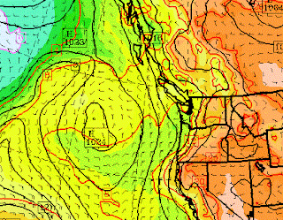
Here is the pressure pattern for 11 AM this morning...you can see the high offshore (solid lines are isobars, lines of constant pressure)
In June, we generally have the high parked offshore, lower pressure over land, and an onshore pressure difference that pushes the low clouds to the Cascade crest. June gloom. As shown in the satellite image above, their is often a sharp end to the gloom near the crest, so sun is just short drive east on I90. Yesterday, I did just that with a friend, mountain biking to the UW Manastash Ridge observatory near Ellensburg. Sun and amazing wildflowers.
We can escape the gloom for a while when easterly flow develops, displacing marine air with dry, continental air. That happened earlier this week when it warmed into the 70s. But real relief often has to wait until July, when the high pressure builds northward and the winds aloft become more northerly.
And if it makes you feel any better, June Gloom is a phenomenon that hits the entire West Coast, including our brethren in southern California (see pic). They always have their hot tubs.
June Gloom at Seal Beach, CA


In this morning's (Monday, May 25) Seattle Times weather map, there are ten Low Pressure areas indicated in the U.S. all west of the Mississippi River . . . and one High Pressure area in SW Montana. Isn't part of the definition of a Low the presence of higher pressure around it? Why aren't there more intervening areas of high pressure indicated on the map?
ReplyDeleteIt's a different story east of the Cascades.Low 80's and plenty of sunshine here in Spokane the last four days,although it's cloudy and cooler today.If the upper level ridge builds as expected later this week,there will be a good chance that May 2015 will end up being the warmest May at Spokane (GEG) since 1958!
ReplyDelete"the results--incessant low clouds--have arrived."
ReplyDeleteThe clouds have been ceasing around ten just about every day, though they do return day after day after day, and that can seem incessant. It's just the plain old marine pattern I grew up with in the Bay Area.
This June gloom always tends to bum me out. There is no energy in it. No sun, no wind, no thunderstorms here in the Western part of the state- not even much rain, at my house anyway. It always hits right after a spell of really nice weather. Just as I have become acclimated to the 70's and 80's, I have to re-acclimate to the high fifties and low sixties. And it can be very persistent.
ReplyDeleteIn my estimation, June Gloom is the west coast's biggest fault, even including winter, because dreariness can be excused in winter. I am from the East, where there is no equivalent phenomenon. In the East, as well as the Rockies, once it gets warm, it usually stays warm and mostly sunny until fall, with brief intense storms (which I enjoy).
Cliff, shouldn't there logically be a "mirror image" of June Gloom: September Gloom? I suggest that if the average position of the high passes to the west of us and brings us first a west wind, creating June Gloom, and then a north wind in July and August, with the clear weather, then it must move south in September before the rains set in, creating a west wind again with a mirror image of June Gloom in early fall...
ReplyDeleteIn San Diego it came in May often enough we called the May Grey and the June Gloom.
ReplyDeleteCan anyone tell me, is the Olympic Rain Shadow exempt from June Gloom, more or less...?
ReplyDelete