
The visible satellite imagery yesterday showed a relatively smoke-free Washington, with the only apparent smoke from a grass fire southeast of the Dalles.

Why are we in better shape than last year? A key difference is less lightning. Last yeas there were more weather disturbances coming through that produced thunderstorms, whose lightning can initiate fires in difficult to access locations. June was also very dry and warm in BC. In 2017 there was a large collection of lightning-induced fires in British Columbia in early July, which resulted in numerous fires in lots of smoke reaching our region. Much less lightning this year.
But things are starting to change. During the past several days we have seen an increase of cumulus and cumulonimbus activity over the Cascades...something that has been very obvious from Seattle ( see below)

The 24h lighting totals for Thursday and Friday (from the National Lightning Detection Network) shows a cluster of hits on Thursday and more scattered strikes yesterday.


I hope none of them started a fire.
The region is now becoming hot and dry enough to sustain major fires, and it will only get worse during the next month, so great care is needed to prevent human-initiation of fires.
During the last 60 days, the Cascades and western WA have been drier than normal, bt close to normal in the Columbia Basin.

Over the same period, temperatures have been warmer than normal over western WA, with the northeast part of the state and the central Cascades below normal.

But the key issue is the recent warmth, with the last two weeks being 2-6F above normal over much of the state.

These temperature and precipitation anomalies from normal are not extreme, but recent warmth and typically dry conditions have left fuels (grass, bushes, etc) quite dry. The most anomalous region is the western slopes of the southern WA Cascades.
The USDA Forest Service has an integrated assessment of fire danger, showing Oregon to be in much more immediate danger than Washington, with the southern Cascades and eastern Cascade slopes being the most threatened in our state.

But it is possible to get a more nuanced view of the fire threat by looking at the Forest Services analysis of the amount of moisture in various dead "fuels." For "10-hour" fuels (mainly grasses and very small vegetation), the dead fuel moisture percentage is VERY low (3-4 %) over the inland west and California (red colors). Small fuels are ready to burn...that is why we are having so many grass fires.

100-h fuels (1-3 inch diameter, large bushes and small trees) are better (less dry), but still below 5% in eastern Oregon and portions of eastern WA. Dry enough to burn.

The 1000-hr fuels (3-8 inch diameter, getting into small trees) are shown next. The lowlands of western Washington are in good shape (green), but deal fuel moistures are 6-10% in eastern WA and Oregon, at dangerously low levels.

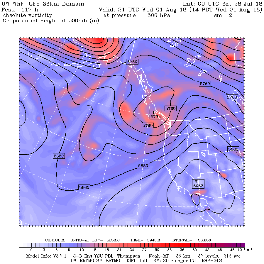
Sunday will be dry and warm over the region, but there will be a continued threat of scattered thunderstorms in the Cascades. The big issue will be mid-week when an upper trough will approach, enhancing the changes of thunderstorms over the Cascades and British Columbia (see upper level map below for Wednesday at 2 PM).
The cumulative precipitation through next Saturday show lots of precipitation in BC (and most of that will be thunderstorms, and some precipitation (again thunderstorm over the Cascades and Rockies. Not much over Oregon.

So the fire season is upon us and the potential for fires will increases progressively during the next month. Western WA will cool down substantially mid-week, reducing, but not eliminating the west-side threat temporarily. But folks will have to be very careful from the Cascade crest eastward--both in preventing fire and dealing with fires that are started by some scattered lightning strikes and human initiation.


You are ignoring the wind. That has been the issue in the Columbia Gorge. I wrote about this in several comments on your post about the Substation fire near The Dalles. Why don't you talk to Bonneville Power and see what they're getting from the wind turbines vs. last year?
ReplyDeleteMake sure to find out how much per operating turbine, and to ask whether any have been shut down because wind levels are too high. We've had some hot days down here, but nothing especially out of the ordinary. We have some days down here every summer.
I think the swing factor in the Gorge has been a good deal more wind than usual. Not only does it (obviously) spread fires, but it also dries out the plant fuel.
The Olympics and Cascades have been pretty smoggy. Is this just do to Smog or are there some fires that have caused this?
ReplyDeleteThe sad part is that we have too many folks who aren't interested in being extra careful, so it's up to the rest of us and our firefighting superheroes to be extra vigilant. As Smokey says "Only ~You~ Can Prevent Forests"
ReplyDeleteThe fire in Redding exploded overnight, forcing mass evacuations there. Terrible, I hope everyone's safe.
ReplyDeleteI hate to bring up the B word, but it looks like the ocean temperatures are warming up off the coast. Would this tend to increase humidity and the probability of thunderstorms in the Northwest?
ReplyDeleteFire now in Cutthroat Pass area west of Mazama. Rainy Pass, Pacific Crest Trail and other nearby trails are now closed. Smokejumpers are on the scene.
ReplyDeleteI did my best to find wind speed data for The Dalles. It's harder than people would imagine. What I could find suggests that my hypothesis is invalid. The graphs I found showed no difference between this year and last year.
ReplyDelete