Fires that have covered much of California with smoke, destroyed thousands of homes, and tragically killed nine people as of this writing.
Importantly, the winds were again highly predictable, poor warning were given to the communities, a failing electrical system may have contributed to one of the fires, and many of the people affected were living in the wildland-urban interface.
This blog will examine the meteorology of the event.
The Current Fires
There are two major fires burning right now. First, is the Camp Fire in the foothills of the Sierra Nevada east of Chico, CA, which is burning towards the southwest and has destroyed the town of Paradise. Nine people have died and approximately 7000 structures have been lost. The town of Paradise is essentially gone. (see map below--acquired here).

The second major fire complex is in southern California affecting the area from Thousand Oaks to Malibu (the Hill and Woolsley Fires). The fire has burnt to the ocean and is now moving towards Malibu.

Satellite Pictures
The satellite imagery is stunning. Both fires started early on November 8th as offshore-directed winds surged. The NASA MODIS satellite imagery around noon PDT shows a plume smoke heading from the Camp Fire towards the southwest, while the fires near Thousand Oaks, were just starting.

The change by noon on November 9th is amazing. Huge smoke plumes that not only covered the entire Bay Area and adjacent locations of central/norther California, but extended many hundreds of miles offshore. The southern CA smoke plume was dense, but much smaller in size.

The air quality implications of the smoke are very serious. The air around the Bay area was far worse than Beijing, reaching into the very unhealthy levels. The EPA AirNow plot of particulate levels (PM2.5/PM1.0) for Saturday morning shows that this serious health threat continues. Unhealthy conditions are found over the densely populated Bay area and the values at some locations to the north are at very unhealthy levels. The health implications of these smoke concentrations are very serious, leading to increased levels of asthma and respiratory problems.

The Origin of the Fires
The fires that began on November 8th were associated with strong offshore-directed winds, known as Diablo winds over central and northern CA and Santa Ana winds over southern CA. The cause of these winds are no mystery: an increase of high pressure over the intermountain West (e.g., Nevada) that leads to a strong offshore-directed pressure differences (pressure gradients), which in turn accelerate the winds. The winds can be locally increased substantially by effects of of mountains (downslope wind acceleration associated with mountain wave dynamics).
To illustrate, here is the official National Weather Service chart for 7AM November 8 (Thursday). The solid lines are isobars, lines of constant pressure. You will notice high pressure over eastern Washington/Oregon that is pushing into Nevada, and a trough of low pressure over coastal California. Between them is a large pressure difference that accelerated the winds.

This pattern is most frequent in the fall. High pressure over the eastern Pacific has retreated, while high pressure builds over the interior as the continent cools and the flow aloft increases. The key "set up" is having a large ridge of high pressure aloft and a trough pushing southward into the SW US. Exactly what we had Thursday morning (see map).

Winds gusted to 60-75 mph in "favored" locations. The max gusts for the 24-h ending 9 AM over the region showed that near Chico there were winds gusting 72 mph in the foothills above Paradise and nearly as strong in the mountains west of Lake Tahoe (see below, click to expand). The observational system is limited, but it was suggesting the limited extend of the strong windsto near the crests and upper western slopes of the Sierra.

Minimum relative humidity during the same period dropped to under 10% along the Sierra foothills:

Southern California observation sites showed 50-65 mph gusts at a number of locations for the same 24-h period.

And the relative humidities were very, very low, with many stations around southern CA less than 10%:

Relative humidity of descending air is usually very low, as air warms as it descents (warm air can hold more water vapor than cold air). Plus, the source region of the air (the intermountain west) is quite dry.
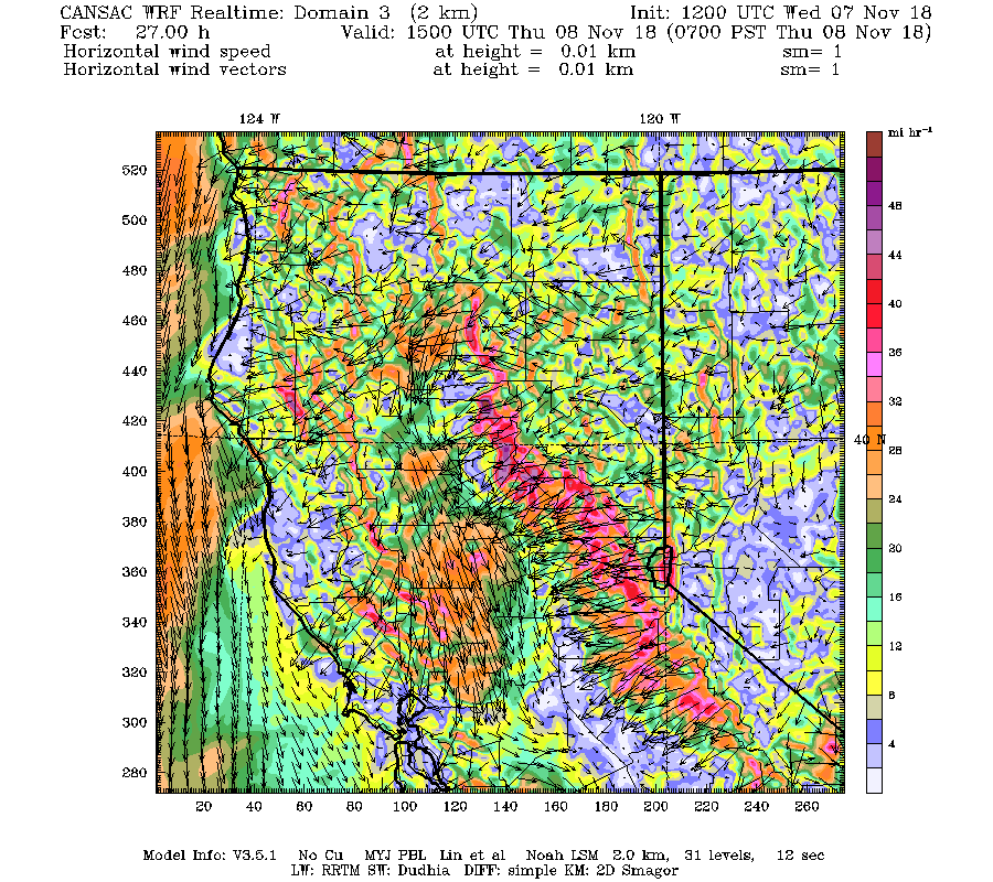
The occurrence of strong winds and low relative humdities were skillfully forecast during the previous days. The Desert Research Institute CANSAC effort runs the WRF model at high resolution twice a day. Here are the sustained winds predicted by their 2-km model domain for the run initialized at 4 AM on Wednesday and valid at AM Thursday (see below). Forecast of sustained wind around 50 mph along the Sierra Nevada western slopes. Gusts would be 30-50% higher typically. Excellent warning
For southern CA, the same model showed winds accelerating at the same time (see below) to 50 mph around east and north of LA.

And then going nutty strong by 1 AM Friday.

Other weather forecast systems showed similar forecasts. The bottom line: the strong winds were expected and well forecast.
These strong winds and associated low humidity were hitting a landscape dry after a summer of little rain and warm temperatures, something typical of California, with its Mediterranean climate (dry summer, wetter winters). The landscape was modestly drier than normal around the Camp Fire, with precipitation over the past six months below normal by 3-6 inches. Conditions around southern CA were near normal.

So the situation was highly favorable for fire. Dry conditions at the surface, low relative humidites, and strong winds that could encourage fire growth and push the fire rapidly away from its initiation point.
And then there is fire initiation. There is some initial evidence that the Camp Fire near Chico was the result of a failure of a high-tension power line that started the fire. PG&E, even with very winds forecast, decided not to de-energize their line--probably a big mistake. Just like the Wine Country fires of October 2017. And just as disturbing, local officials did not use the Amber Alert system to warn people of the exploding Camp Fire.

The initiators of the southern California fires is still not known.
The latest surface smoke forecasts over California from the NOAA HRRR smoke system is not optimistic for today: a LOT of smoke over the Bay area and LA (see forecast for 6 PM this evening)

Bottom Line: Our ability to forecast these wind events has become very, very good. We knew how dry the conditions would be. The threat was clear. It is unfortunate that powerlines appears to start the Camp Fire and that the lines were not de-energized before fire was initiated. It is doubly unfortunate that we do not seem to be able to warn people effectively when such fast-moving fires are occurring. And the threat of so many people living at the urban-wildland interface is made clear again.


Thanks for a good analysis of the California wildfires. One thing that people may not be aware of is that high winds can carry glowing embers a half mile or more. These can start new spot fires. In central Washington wildfires have been known to jump the Columbia River. I talked to my rancher neighbor whose land burned this summer in the fire that threatened Grand Coulee. He told me that the fire burned over 10,000 acres an hour the first four hours. There was no way anything could outrun it. It could well have wiped out Grand Coulee which was evacuated. Under those conditions I don't think buffer zones between towns and wild or grazing lands would do much good. I agree fire prevention is the best course of action.
ReplyDeleteFerdi Businger
Cliff, When you talk about these fires you often mention the wild land-urban development. It makes me wonder: Could this happen in our area, specifically in the eastern flora-rich 'burbs like Sammamish, Issaquah, Snoqualmie, North Bend, etc...? I realize, of course, that we don't have the same weather or climate as California, but with the changing climate (longer, warmer summers) it makes me concerned that us Eastside dwellers might one day need to consider the wildfire risk, even more than the "big one". Hoping you'll put my mind at ease...
ReplyDeletePlease tell us that global warming isn't involved in these fires, Cliff.
ReplyDeleteThanks for this thorough analysis.
ReplyDeleteSarah Jane, you are correct to be concerned. From a firefighter's perspective I don't think we are close to California-like fire conditions, but every summer our fuels get very dry and ready to burn. The one saving grace that keeps us from having catastrophic fires is that significant wind events in the summer are very rare. By the time it starts to get windy in the fall, the rains have arrived and fuels are moist again.
ReplyDeleteBut here in Western Washington, it's time to think like our neighbors to the east and practice fire-wise landscaping. We need to stop using bark mulch near structures (my department usually gets at least one significant structure fire caused by fire spreading from bark), and people should keep flammable shrubs like juniper and arborvitae at least 20 feet from their homes. It's not too far-fetched to imagine a mountain wave offshore wind event in the early fall following a hot, dry summer. If that happens, firewise landscaping practices could easily make the difference between minimal damage and losing a home.
I thought this was a great blog piece about how the use of meteorological data and prediction should be put to better use to save lives. Nevertheless, I think Cliff missed an opportunity to raise awareness as to how climate change (a factor which Cliff has previously acknowledged) is predicted to increase further risk and is one of the levers which we can use, along with better land and forest management plans. Indeed, the climate change lever will become more and more important, even as we improve our land management policies.
ReplyDeleteThe NYT is reporting: "But while California’s climate has always been fire prone, the link between climate change and bigger fires is inextricable. “Behind the scenes of all of this, you’ve got temperatures that are about two to three degrees Fahrenheit warmer now than they would’ve been without global warming,” Dr. Williams said".
Meanwhile back in 2015 researchers (including PJ Rasch from the PNNL labs in Richland) were already predicting increasing fires in California. Rather than just look at number of historic fires and total area burned, these researchers use an index that combines temperature and precipitation data, the KDBI. This index correlates well with the increase in burned area since the eighties, and ominously shows a fairly steep rise in the decades ahead. According to their model, global warming has more than doubled the extreme fire danger days in recent years.
In any case, I am not a climate scientist or meteorologist, so I would appreciate any critique from Cliff or others on using the KDBI index to predict the incidence of future forest fires.
Is it possible to forsee which electrical lines are becoming a hazard?
ReplyDeleteIf folks remember, there was a recent wildfire near Twisp, Wa that was started by faulty electric utility lines which resulted in the death of three fire fighters and one other severely burned firefighter.
Also, it seems as though our Eastern Wa forests remain open to camp fires far to long into the start of the dry season with complex rules for where camp fires are allowed.
I remember calling the Forest Service concerning a Campground campfire during the dry part of the season when a lot of Okanogan County was under a burn ban. I was surprised to learn that one particular Campground was open to campfires.
Concerning the California Camp Fire, I'm not understanding how a Safeway can burn or Big Box stores can burn seeing how they're surrounded by asphalt? Very eye opening.
Yes Cliff, many people live within the Forest urban interface. People also live in Tornado areas, hurricane areas, flood zones,land slide zones and earthquake zones. Not to mention all the folks who live in the disaster shadow of Mount Rainier.
People have to live somewhere.However, people need to adhere to best safety protocols for a given risk. Its a long list that we tend to ignor or simply don't understand to well.
My heart grows heavy for those in harms way.
Chris H.
Heli-free North Cascades
Chris H, it does boggle the mind that these commercial structures will burn despite the fact that there are no trees or brush nearby. As another commenter mentioned, during these events embers can be blown hundreds or even thousands of feet. They land on roofs and lodge in flammables stored around the buildings. The kicker is that during these events there are not nearly enough available firefighting resources to address all the fire problems that crop up, and municipal water supplies don't have even a small fraction of the capacity to support all of those resources were they available. Right now there are dozens of engines and hundreds of firefighters from outside California-including from Washington-enroute to provide assistance. But getting them there takes time and is very expensive. It's not widely known, but fire departments are staffed for efficiency, not resiliency. Most fire departments have barely enough staffing and equipment to handle their routine call volume, and they are almost always immediately overwhelmed when events like this occur.
ReplyDeleteJohn K, Sarah Jane
ReplyDeleteI think western Washington and Oregon have been fortunate in recent years in not experiencing an episode of strong, dry east winds during the critical fire period for that side, late August into September. These strong east wind periods at this critical time are not frequent, and especially it seems in recent years, but were the main weather factor in the large fires on the west side in the past, such as the Yacolt fire of 1902,the Dole fire of 1929, Tillamook fire of 1933 and the Forks fire in 1951. Some of these fires were not even preceded by especially dry seasons but it does not take much time to dry out the forests under strong east wind episodes. I think you do need to worry about this happening at some time in the future when a strong east wind develops during this critical later summer/early fall period.
Jim Holcomb
Impressive post of a tragic situation.
ReplyDeleteAll time record low recorded at Sea-Tac airport this past Friday? Nada mention? Even in Cali the night time lows are pretty darn cold and these Santa Ana events are not at all uncommon. In fact, it's why the landscape is naturally so sparse anyway.
ReplyDeleteHow about a talk about our weather up here though. Lots of cold night in October, an enormous amount of rain in September, and pretty darn cold nights already here in November and day time highs not all that warm and it's not winter.
Thanks again Cliff.
During a fire in Wentchee that was mostly grass the embers blew a couple of miles and torched a warehouse that wasn't even close to the flames. I would think the fires in CA being more intense would make this mechanism much worse.
ReplyDeleteAs you stated one of the factors is the cold weather driven high pressure in the Nevada/Utah basin. It looks like the temps. there are well below normal. Is this driving higher wind speeds?
Thanks wff225.
ReplyDeleteI thought that was the case and then there's the heat. Organic material does not need to come into direct contact with fire in order to burn it only needs to reach a temperature of, I believe, 454 degrees Fahrenheit.
And then there's the famous "house in the middle from 1954". The house in the middle would be an example of following the best safety practice protocols with nothing to burn or provide a place for Embers to settle.
https://www.google.com/url?sa=t&source=web&rct=j&url=https://m.youtube.com/watch%3Fv%3DlrYjVv9SyMQ&ved=2ahUKEwihpPa1lc_eAhWWITQIHYfpDoMQtwIwAnoECAcQAQ&usg=AOvVaw0UO6Fmi_hkMfixrX5OQffA
I remember a fire in Wenatchee where Embers were blown into an apple processing Warehouse. Lots of pallets and apple bins to catch embers and catch fire and in turn spread fire.
Currently I'm in a battle with an HOA in a development where I've already built two houses and getting ready to build a third.
They don't want to enforce covenants that require property owners to maintain their properties in a safe manner. The development is basically in a forest.
People desire to have brush and trees around their houses for privacy, while their neighbors are taking steps to maintain their own properties while the HOA is focused on maintaining the Greenbelt in common areas
The development is mostly vacation homes owned by wealthy westsiders with good insurance policies.
I believe the insurance companies need to be more proactive. If your house is an ember trap the insurance company's need to say clean it up or lose your fire policy.
And a shout out to G. Linden and his volunteer firefighters of Vancouver Wa. They came up and defended my house during the Carlton Complex fire.
He credits me for my choice of using fire resistant building materials and clearing brush around the house but I was not following safety protocols and left a cord of firewood stacked up next to my house.
Those firefighters moved that wood and reinforced. the fire line that I had dug. I credit those guys for saving my house.
Chris H.
Heli-free North Cascades
The info desk is probably correct, especially in areas like North Bend, but perhaps the trees we have here in the populated portions of W WA are currently less likely to go-up in flames en masse.
ReplyDelete