_____________________________________-
The cold is still on track to reach us. Here are the latest model forecasts.
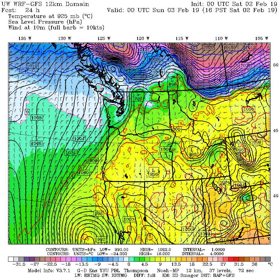
At 4 PM cold air (purple and dark blue colors) are just north of the border (the solid lines are sea level pressure)
By 10 AM Sunday, the cold air has started to push into Washington State, with the really cold stuff moving into Montana. Importantly, a low center is right along the coast.

The low center, which will have some precipitation associated with it, moves southward during the next day, and is positioned off of central Oregon by 10 AM Monday. Extensive cold air is over WA State.

And by 10 AM Tuesday, the entire NW is in the deep freeze.

The cold air, and associated strong winds, will pour through the Fraser River Valley gap, northeast of Bellingham. At 10 AM, a jet of northeasterly winds will push across NW WA from Bellingham to Blaine and surge into the San Juan Islands (see gust forecast below).


Snow? Over the next 24 hr (ending 4 PM Saturday), the north Cascades will pick up 6 inches to a foot. Good for Stevens Pass and Mt. Baker.

During the subsequent 24h (through 4 PM Sunday), not much over the interior, but light snow will be observed along the coast as the low center moves southward.

And now the scary stuff. The latest forecast run puts down a few inches during the 24 hr ending 4 PM Monday from Puget Sound down to Portland (see below)--with most of the action early on Monday.

There is a great deal of uncertainty with this forecast...it critically depends on the strength and position of that coastal low. The ensemble forecasts are all over the place, with some predicting no snow over Seattle. But the model runs are trending toward more snow. Will update on Saturday.


Loving that last model run!
ReplyDeleteHope this forecast is right because everyone else is saying nothing for the Puget sound at all
ReplyDeleteI wouldnt say that, national weather service is putting a chance of snow Sunday night and Monday.
DeleteI love the looks have that last run!
ReplyDeleteThanks! Reports on local news outlets seem useless to me--just vague pictorials meant for the whole region with no narrative. I appreciate a meteorologist actually using words to describe what is happening. Imagine that.
ReplyDeleteNice post! I did my weekly shopping a day early to take advantage of whatever happens.
ReplyDeleteIt's so fun to anticipate snow when you don't have it often. I get excited based on all my good snow memories even when knowing it may not happen this time.
Perhaps sometime Cliff will give us a rudimentary explanation about what goes into the modeling.
Hey Cliff,
ReplyDeleteBased on previous comments (on the central Oregon downslope wind event) there are at least a few ex-Seattle people living in the Bend (ish), OR area who read your blog. For example, I still enjoy the analysis, and I forward on the alerts to my renters back in Issaquah.
My request:
For situations like this PNW cold/snow event, or just on occasion, could you please include a mini-analysis for the Bend/Redmond/Sisters area, too?
Our "local" NWS office in Pendleton covers an insane amount of varied territory, hence our forecasts are ... general at best. For example, simply driving from downtown Bend to the local KRDM airport frequently means a 5-8" snow differential and none of our microclimates are picked up in any forecast.
Yes, I know, "if you give a mouse a cookie the mouse will next ask for weather analysis in Prineville" :-) But it would definitely be appreciated, at least by your small band of followers out here in the high desert.
Thanks,
Dave
Thanks Cliff for your no hype factual opinion.
ReplyDeleteUnfortunately one of these days we are going to have a truly serious weather event and the forecast won't get the attention it should because of all the BS hype by the talking heads in the local media.
Cheers sir to job well done!
Forecasts in general in the past 24 hours seem to be trending warmer. It wasn't supposed to get above freezing from midday Sunday through Monday but now it's a high of low 40s forecasted (Bellevue). Seems like the chance of snow is dropping dramatically
ReplyDeleteThanks for showing us the science behind the forecasting including the uncertainty and the reason for it.
ReplyDelete