
The latest weather radar imagery shows the snow, but this is probably not an accurate rendition of the true state of affairs.
Why? First, snow does not show on radar as well as rain (ice does not scatter microwave radiation as readily as liquid water). But more important, Oregon has terrible radar coverage. I mean bad. They don't have a weather radar on the coast and much of eastern Oregon has zero radar coverage in the lower atmosphere. The eastern slopes of the WA Cascades are not much better.
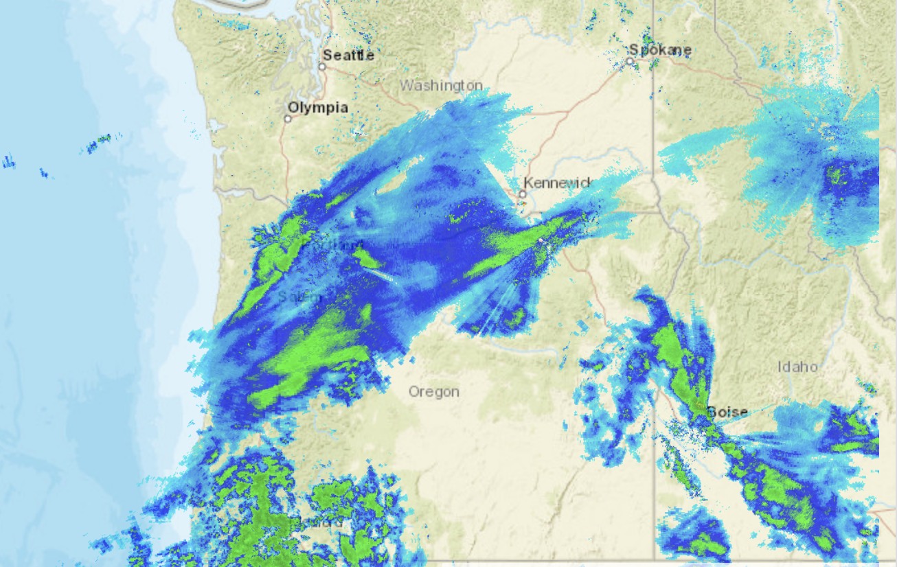
The folks in Oregon should be up in arms about this--and they need someone like our Senator Cantwell, who pushed for the Langley Hill radar on our coast.
A six-hour forecast of sea level pressure and low-level (2500 ft) temperatures for 10 AM today predicts the low center will be over the southern Oregon Cascades at 10 AM ( see below). Very cold air is over BC and eastern WA, with simply cold air over western WA and NW Oregon. Extremely cold air is found over central and eastern Montana, illustrating how the Rockies protects us from the really primo cold stuff.

Snow will not get near Puget Sound, but central Oregon will be buried. Here is last nights UW WRF model forecast for total snowfall for the 48 h ending 4 PM Tuesday. In Washington, Walla Walla will get a piece of it, but the real action will be south of Salem. You will not want to go to Eugene, which will resemble Siberia before this over.

This snowfall is really a gift from the weather gods for Oregon. A month ago, there was substantially below-normal snow pack over the Oregon Cascades. By the time it is over, Oregon will have a normal snowpack. Very good news for water resources, fish, and the ski industry..
Here in western WA the weather story the next few days will be dry, cold and windy. Cold, dry northeasterly flow is now pushing through the Fraser River valley into NW WA, with gusts to 30 mph and more as I write this (see surface map below). With a strong pressure difference across the Cascades, gusty easterly flow is now descending into the Cascade foothills from Enumclaw to North Bend.


A dry, partly sunny, but cool week is ahead. Will we end up with the coldest February on record at Sea-Tac? It will be soon time to run the numbers!


I was in the local grocery yesterday in SE Portland, when I heard a few people loudly complaining about the cold and the snow. I asked them if they really wanted a repeat of the last two summers of forest fires, the Gorge fire went on for weeks while the fires from CA last year choked the city out for many days. They really didn't have a response to that reality.
ReplyDeleteHow will snow now stop fires later?
DeleteLooks like GFS won this round.
ReplyDeleteGFS 1 Euro 1
This morning there is a foot of new snow on the ground here in NW Bend, OR and its still coming down at a furious pace.
ReplyDeleteWith the godforsaken northeaster in north Whatcom County and real feel temps in the teens, the "enjoyment" is relative.
ReplyDeleteHere outside of Redmond Oregon (2770 MSL) we just hit 30" accumulated snow in the last ~28 hours. Totally unforecast.
ReplyDeleteThe Winter Storm Warning we're under STILL says "Total snow accumulations of 7 to 14 inches expected" between Sunday and Wednesday. Bwahahahahahahaha.
Our current NWS forecast calls for 6-10" today. My uneducated look at what low-res radar loop is available says we should easily double that accumulation.
Unless our moisture source dries up in the next few hours (?), I have no doubt we'll blow right past 3 feet on the ground today.
Luckily for us, our power lines are buried and there are not many tall trees in the high desert anyways. And we're set for food for a few days, which is good because I'm clearly not getting even my 4x4 out of the driveway for the next couple days. But even though this is snow country, I'm not sure everyone is as prepared for *this* much snow.
Then again, my border collie thinks she has died and gone to doggie heaven. She simply refuses to come inside. When no one is shoveling snow for her to catch, she just burrows in and tosses snow in the air - pure joy :-)
Very fine light snow in Tri-Cities, WA since about 9:50 am this morning. Lots of ice.
ReplyDeleteCliff said - "By the time it is over, Oregon will have a normal snowpack."
ReplyDeleteThey have had a normal snowpack for weeks Cliff. In fact way above normal in eastern Oregon. This only adds to it.
What stats are you using to suggest they aren't? Even the USDA maps show virtually the entire state at or above 100%. Eastern OR by section today: 135%, 137%, 123%, 148% etc. https://www.wcc.nrcs.usda.gov/ftpref/data/water/wcs/gis/maps/west_swepctnormal_update.pdf
BTW... where are the people who told us ad nauseum last fall that Oregon was headed for a drought this year? The ones who spread fear on a weekly basis... any accountability for that (once again) stunningly wrong forecast?
I'm glad this snow event skipped Seattle, Cliff. Also, it's good Oregon's snow pack with benefit. Great job predicting the outcome!
ReplyDeleteCold temps with sunny skies feel pretty good to me right now--like home. My plan is to soak up some rays.
sunsnow12 said...
ReplyDelete"Cliff said - "By the time it is over, Oregon will have a normal snowpack."
They have had a normal snowpack for weeks Cliff. In fact way above normal in eastern Oregon. This only adds to it."
If you had run this report only a few days ago, it would have looked much different, particularly for Oregon:
https://fortress.wa.gov/ecy/wrdocs/WaterRights/wrwebpdf/wtrsupplyupdate-02222018.pdf
Keep in mind that from a global warming perspective, the comparisons are for the period 1981 to present. The research showing decreased snowpack looks at a much longer historical period.
Even with what seems like a lot of snow, most of the northwest is still not much better than average for the comparison period.
My brother-in-law lives in Eugene and said they had at least 8 inches of snow this morning! I just read a report on OregonLive.com that Eugene airport received 11 inches, Cottage Grove, which is just South of Eugene got 14 inches! Diamond Lake in Central Oregon Cascades got 4-6 feet!
ReplyDeleteInterestingly, Bandon, Oregon, on the coast had 6 Inches of rain!
Buahahaha. Yea. Almost tore the wind of the ole lexus earlier. Well let’s look at it this way, last year we had no snow and very little cold. But many folks suffered with a hellish flu, I myself have to go on anabiotic‘s to get rid of A lung condition that was flirting with pneumonia, But hey, this year I’m sound as a whistle. But need a few miligrams of “weather rx”. Surely we can find something to be thankful about right ?
ReplyDeleteKeyword to me is dry.
ReplyDeleteAt least on the Quimper Penninsula, it appears to be a very dry "wet season" so far.
Very dry. My seasonal pond is dry, local lakes are at summer low levels. I have found dry Dusty dirt in dirt piles.
I would say cold dry and windy is not only the coming week but the winter as a whole, sans our false spring in January.
Your region must have been in a rain shadow alot this season. Some areas got hit with alot of rain like the south facing slopes of the North Shore mountains of Vancouver BC which clearly took the brunt of the SW flow that was prevalent before February. From late October to the end of January, Coquitlam BC (a suburb of Vancouver NE of the city) had almost 70 inches of rain. So far this February there is below normal precip but still almost 5 inches so not record dry by any means. Solid snowpack too. March can also be a very wet month around here
DeleteLight, light snow in Issaquah
ReplyDeleteWe received 10" last night here 30 miles N of Eugene. A fair bit more than the 1"-3" range in last night's National Weather Service prediction.
ReplyDeleteI was so happy today to see Willamette Basin index reach 100% today. Not that long ago it was languishing along at around 60%, Hoping to see Hood, Sandy, Lower Deschutes Basins up to that level soon. Still its at 88% up from around 49% for a bit. Both those regions are important to two major population centers. Even the Klamaths are looking decent. For a change this year its been eastern Oregon basins consistently coming in at >100%.
I live on Bowen Island (Vancouver's equivalent to Bainbridge Is). But with a big difference- we are at the mouth of Howe Sound, and the outflow winds can be ferocious. In Jan. 1991, they were measured at 77 knots at Pam Rocks. Today, they are 34 gusting 45 knots.
ReplyDeletehttps://weather.gc.ca/marine/forecast_e.html?mapID=02&siteID=06400
Last week they were in the 50's. Under these conditions, there is little to no wind at Pt. Atkinson lighthouse or Vancouver (sheltered by the North Shore Mountains), and stronger than what blows out of the Fraser Valley that easily crosses the line around Sumas...
The best local predictor of arctic outflow winds (besides pressure gradients and the like) is to look at the Marine Weather reporting station of Cathedral Point.
https://weather.gc.ca/marine/forecast_e.html?mapID=02&siteID=06400
Organic Farmer -
ReplyDeleteI am curious on this one, as "very dry" (vs. avg) would differ significantly from other western WA locations in the 18/19 water year... maybe due to an enhanced Olympic rain shadow pattern? Any stats you have vs. avg from your location, or maybe Port Townsend or Sequim?
Some W. WA examples: Seatac currently at 99% precip for the water year; Hoquiam 103%; precip at Chester Morse reservoir (Seattle Water Supply) 101%. Snoqualmie Pass is currently measuring 93" snow vs. +/- 69" 5-yr avg (135%). Stevens is at 89" vs. 72" (123%), etc.
Cliff wrote: " The eastern slopes of the WA Cascades are not much better."
ReplyDeleteWe live near Ellensburg. Our reporting office is Pendleton, OR., and there is radar there.
We are 126 miles from there. We are 93 miles from Seattle. When we look for the radar image, the default is Seattle.
However, the Cascade Crest is in the way, so that shows zilch about our location. Thus, there is an extra step involved to get the Pendleton radar. Spokane radar is 146 miles away.
A couple of years ago I wrote to NWS Pendleton and asked if I could get their radar by default. The answer was no, it is a national thing, and the coder likely was a "flatlander" from Wash. D.C.
From the Ellensburg area to the north, we don't get much respect, or radar either.
MAC -
ReplyDeleteAre you serious? You linked to a map from February 22, 2018. That is a year ago. Why would you do that?
Snowpack in Oregon has been steadily increasing for the last six weeks, but even at the beginning of January all of eastern OR was above average.
Historically, snowpack in the WA Cascades has been increasing for the last 30 years. Cliff has pointed it out plenty of times. The stats are easily available for someone like you.
I was going to write more but really, we've been over this all before. Just makes me tired.
Wow, We went from one of the warmest starts to Jan to a cold Feb. Meanwhile a good chunk of Arctic regions is having extreme warm anomolies. Global warming sucks
ReplyDeleteSorry for linking to 2018 data. Here is a link to a January 2, 2019 and February 1, 2019 report:
ReplyDeletehttp://mountainjourney.com/snotel-data-20190102/
https://wcc.sc.egov.usda.gov/reports/UpdateReport.html?textReport=Oregon&textRptKey=10&textFormat=SNOTEL+Snow%2FPrecipitation+Update+Report&StateList=10&RegionList=Select+a+Region+or+Basin&SpecialList=Select+a+Special+Report&MonthList=February&DayList=1&YearList=2019&FormatList=N0&chkDst=on&OutputFormatList=HTML&textMonth=February&textDay=1&CompYearList=select+a+year
An Oregon Snotel map for February 1, 2019 (I can generate a PDF but cannot make a link - sorry). It shows snowpack in the 50 to 75% range in Oregon for that date:
ReplyDeletehttps://www.nrcs.usda.gov/wps/portal/wcc/!ut/p/z1/pZExb4MwEIV_SwfG-o6EErebw5CkRErbpAm5JTKUAlIwCDux-u9LxZqaSr3Bks_fe_esA4IESMlrVUhTNUqe-_uRwtNqwsWSbzFeREGA4jGa7dbbGcZvD3BwArsQqH_mPAr8TYBrjFHga8Tjfbjc-5uXyYh-jn_T4y8lBv1ofscA-s__e4Dc8Q5AYwg5M8zHgJ8dOIGpD89AxblJh4ULlU55AdTln3mXd-zS9e3SmFY_eeihtZbZLGOqyzS76A_JiubqoVaNHc5TLVtWmvqmWdloA8lND2jr974SrFb3lH7Zu282F_6j/dz/d5/L2dBISEvZ0FBIS9nQSEh/#version=103&elements=R&networks=!&states=OR&basins=!&hucs=&minElevation=&maxElevation=&elementSelectType=all&activeOnly=true&activeForecastPointsOnly=false&hucLabels=false&hucIdLabels=false&hucParameterLabels=false&stationLabels=&overlays=&hucOverlays=&basinOpacity=100&basinNoDataOpacity=100&basemapOpacity=100&maskOpacity=0&mode=data&openSections=dataElement,parameter,date,basin,elements,location,networks&controlsOpen=true&popup=&popupMulti=&base=esriNgwm&displayType=basinstation&basinType=or_8&dataElement=WTEQ&depth=-8¶meter=PCTMED&frequency=DAILY&duration=I&customDuration=1&dayPart=E&year=2019&month=2&day=1&monthPart=E&forecastPubMonth=6&forecastPubDay=1&forecastExceedance=50&seqColor=1&divColor=3&scaleType=D&scaleMin=&scaleMax=&referencePeriodType=POR&referenceBegin=1981&referenceEnd=2010&minimumYears=20&hucAssociations=true&lat=43.531&lon=-124.002&zoom=6.5
I just did a search and found all sorts of Oregon newspapers (older than this storm) lamenting the below normal snowpack recent recent articles (after the storm) updating that the snowpack was back to normal.
ReplyDeleteI only checked because I was curious about Cliff’s report not to flame you.
Sorry. I'm the unknown.
ReplyDeleteAt 8:19 I made a comment, and I did not intend to not use my name.
John F. Hultquist
north of Ellensburg in central Washington
"How will snow now stop fires later?
ReplyDeleteHaving an average snowpack helps immeasurably with fire suppression efforts later on when the weather turns dry. OTOH, the increased foliage at times can become troublesome if the summer months turn out to be abnormally dry. Take a quick look at other sites for more information on this topic. The entire West coast is above average for snowpack (most are far above), so unless we have above average temps from here on out and the soils dry out prematurely, the outlook looks good.
Exactly. Per your map MAC, the entirety of E. Oregon is green on January 2nd.
ReplyDeletePer sub-section: 103%, 96%, 97%, 106%, 100%, 103%, 116%
In fact, out of the 11 sub-sections in the entirety of the state, 7 were at - or above - normal seven weeks ago . And since that time they have received more snow - substantially more snow. And yes, I disagree with Cliff that "this storm" will put them into the green. They have been in the green for weeks. In fact now they are well above that.
Yes, SalishT, newspapers like to cherry-pick out negative news. I don't. I like to look at the positive. And the positive for the entire NW this year - against a continuous chorus of negativity, drought-mongering (every year now), and low precip predictions/forecasts that have been stunningly wrong (again) - we are once more looking at a very healthy year for water in the NW.
And I want to make it clear here - I come to this blog because Cliff is one of the few who tells the truth on this. I disagree that this storm is the key to putting Oregon over the top, but that is a (very) minor disagreement in the larger picture. If it were not for Cliff, we would get nothing but lies and misinformation on water supply -- he has been huge on keeping the discussion honest.
Thanks Cliff for again pointing out the lack of radar on the central Oregon coast. Right now, the Mt Ashland radar is out and the closest radar we have here in the Rogue Valley - where it is currently snowing hard - is Arcata! Difficult to infer much from that, and, as you point out there is never any good radar for the Central Oregon coast. I am going to get our great Oregon senators Merkley and Wyden working on that if I can.
ReplyDeleteDr. Mass has paid the price for his objectivity, Dr. Richard Feynman would be proud.
ReplyDeleteWow, We went from one of the warmest starts to Jan to a cold Feb. Meanwhile a good chunk of Arctic regions is having extreme warm anomolies. Global warming sucks
ReplyDeleteUm, cultist? There's a lot of volatility in the weather in this region. Always has been, always will be. No reason to bring your church into it. There's a very good book about the region's weather. It's called The Weather of the Pacific Northwest. You should consider reading it.
"sunsnow12 said...
ReplyDeleteExactly. Per your map MAC, the entirety of E. Oregon is green on January 2nd"
Hate to break the news to you, but the Cascades are the main source of water.
As of February 1, most of the Cascades and Siskiyous were in the 50%-75% of normal range. By February 1, most of eastern Oregon was also below normal. Things got worse between January 1 and February 1. Look at all the links and you will see this is the case.