If you live in eastern Washington on the slopes of the Cascades, you might want to make sure you have a snow shovel.
If you live in western Montana, you might want to get your chains ready and stock up on food.
An unusually early and intense Arctic express will hit the region this weekend. And our days of Blob warmth will be over for a while.
Let me start by showing you a stunning image from the NOAA/NWS Climate Prediction Center (CPC)--their 6-10 day forecast for temperature. Specifically, it gives the probabilities of below normal (blue) and above normal (red) temperatures.
Wow--- my colleagues in NOAA are quite sure that below-normal temperature will reign along the entire West Coast as well as the northern Plains States.

The action starts late Friday.
A huge upper level ridge develops in the Pacific, resulting in northerly flow over the western U.S., with a strong trough of low pressure/heights moving into the Pacific Northwest (see upper level-- 500 hPa map for 5 PM Friday below). This pattern will not only bring Arctic air south over the Northwest but will isolate the Northwest from the warming impacts of the Blob (the region of warm water over the northeast Pacific). As a result, western Washington will experience much colder minimum temperatures than observed during the past few months.

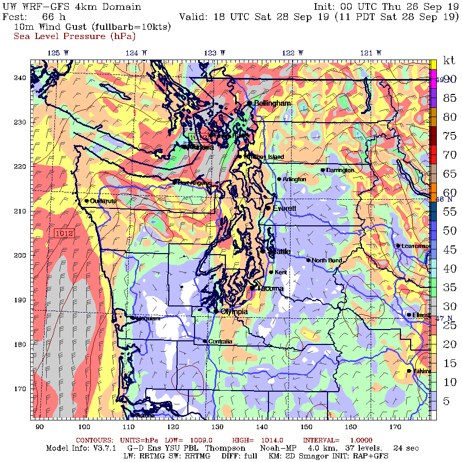
Now the details. Here is a forecast map for 8 AM Saturday, showing sea level pressure (solid lines), lower atmosphere temperatures (color shading) and surface winds. There is an intense pressure change (gradient) near the international border, with cold temperatures behind---this is commonly called the Arctic Front. Low pressure, associated with the upper level trough, is centered over SE Washington.

By 5 AM Sunday morning, the cold air and large pressure gradient has pushed south. Eastern Washington, particularly to the east of the Cascade crest, get a piece of it. Montana gets half the pie...with a huge pressure gradient--which means very strong winds will accompany the cold air.

Western Washington will escape the precipitation because the low is too far inland and we will be in the easterly (dry) descending flow. But Bellingham and NW Washington will get very windy, as shown by the forecast for 10 AM Saturday. Wind gusts could get to 35 knots (about 40 mph) from Blaine-Bellingham to over the San Juans. Even in Seattle, winds could breezy and from the north.
Snow? You bet. The temperatures aloft will be cold for this time of the year. Here is the forecast for 850 hPa (about 5000 ft), with the colors showing temperature and the sold lines showing heights (like pressure). Frigid (below -6C) air over northern eastern Washington, Idaho, and Montana, associated with strong easterly flow.

This means snow. Snow accumulation through 5 AM Sunday (below) show several inches of snow on the eastern slopes of the Cascades, and immense amounts (feet) upstream of the Rockies. Spokane will probably see snow flakes. I suspect there will be some daily temperature and daily snowfall records broken in some locations during the next few days.


so this arctic express will stay for a short amount of time or will it stay fir the remaining of winter and when do you think we will get are first snow???
ReplyDeleteShort time. Looks to be gone by mid week...
Deletethanks man i'm just learning
DeleteHey Cliff - I assume you've seen the IPCC report on oceans. They disagree with you on the link between climate change and oceanic "heat waves" (ie, the Blob).
ReplyDeleteCare to address?
I read the paper they cited and papers suggested to me by Nick Bond, the originator of the blob terminology. None make the case that global warming will enhance the blob. Can you suggest one to me? Can't find one..cliff
DeleteIs this the stuff to which "another guy" is referring?
Deletehttps://www.google.com/amp/s/www.theverge.com/platform/amp/2019/9/25/20882502/marine-heatwaves-oceans-united-nations-ipcc-report-climate-change
Thanks for the link @Caroline
DeleteOcean heat waves have major economic impacts which is why even CNBC is reporting on that part of the IPCC report
https://www.cnbc.com/2019/09/25/major-climate-report-discovers-rapid-ocean-warming-is-causing-heatwaves.html
Ocean heat waves occur when the daily sea surface temperature exceeds the local 99th percentile of the temperature between 1982 and 2016. Beyond that, global ocean temperatures have warmed every year since 1970, with the rate more than doubling since 1993.
Cliff, can you add some historical data/comparison for the puget sound area?
ReplyDeleteI've lived here nearly 40 years and don't remember having a cold front this size so early in the year...i.e. september.
I think we had a similar cold/wet September in 2013. Just normal climate variability.
DeleteBut the farmers Almanac isn't sayin' it
ReplyDeleteIf it were as much of a departure on the warm side, we'd be hearing all about "climate change" from the Usual Suspects here.
ReplyDeleteThe climate is changing, there's real data to prove it. Even cliff says that the climate is being influenced by our emissions.
DeleteThe climate is always changing. Got any more stunning insights?
DeleteIt's the extremes... After all this is only September...
DeleteThe climate is changing at a rapid pace that also correlates with an increase in human caused emissions. Stop fighting facts "Placeholder", please.
DeleteOn the outskirts of Youngstown, Ohio in the villages of Poland and Boardman on July 4th 1965 or 1966 Poland received an inch of snow and Boardman got a dusting. The white stuff was completely melted by 10:00 a.m. So this kind of thing has happened even in July. btw The temperature the day before was in the mid 70's and the fourth hit the eighties. My thermometer read about 38 degrees Fahrenheit at 6:30 a.m. The cold woke me up as my bedroom window was open. I looked outside and saw snow I contacted WFMJ weather team and asked what happened. They responded thanks for the information. The record low was set in 1968 at 48 degrees and in 1995 at 43 degrees Fahrenheit. In the sixties we were worried about the coming Ice Age being brought about man's action how the times have changed.
DeleteRecords show climate change is not unusual over the last few centuries according to an internet site I saw a long time ago. Possibly our change is more drastic because of all the emissions we throw into the air.
Delete@Sam Demco, the numbers show that your claim is false, but you are a "progressive" so facts don't matter to you. The real problem is that "progressives" have abandoned conventional religion but still need myths to believe.
DeleteGrats Cliff. You are on Zero Hedge. Wasn't me. Dubious honor at best if you read that site and the commentary. Lots of people with no filters over there.
ReplyDeleteAs for this winter.....
Yah, anyone's guess. 100% chance of sunrise and sunset...with a few pointless time changes just to trip everyone up. It will probably get cool, and damp. With some of the damp colder than other damp(frozen). Seems like we might be in uncharted territory? There is a thing off the coast (Blob) that says warm, but here we are....
“Weather forecast for tonight: dark. Continued dark overnight, with widely scattered light by morning.”
― George Carlin
Just to add:
ReplyDeleteMontana has deciduous trees as well. Even as far north as they are, they will have most of their leaves and the snow will be wet. Enough to do damage on an unfortunate scale to trees. Roads can't be plowed when choked with trunks, limbs and down utility lines, so its a waiting game for utility crews for the snow to melt before they can work. Montana residents need to stock up on essentials and test their generators. This is serious.
cliff i would be happy if you replied to this, but i'm very into weather and just learning im 14 turning 15 this dec, and would love to know if we will have an above average temps for this winter??!!
ReplyDeleteblow average with more snow sorry that is what i meant
DeleteThe blob can go away in a couple days. Remember guys that is "surface" temperature, a very shallow surface that is actually warm. Wouldnt take much for it to go away.
ReplyDeleteCliff, I'm glad you are reminding people to be prepared for the cold by physical location! Thanks for your good work on the public's behalf.
ReplyDeleteAt 12:20 we had a wild thunderstorm with lightning and large ice pellets (1/2" or so) come through Port Ludlow. Haven't seen any damage yet, but it was very violent.
ReplyDeleteSo, to change the subject, what are the chances that the Northern Lights will be visible? (I'm across from Mystery Bay, and minimal light pollution here.)
ReplyDeleteWill the skies be clear at night ?
Will Boise Idaho have below normal temperatures and above normal snowfall this Fall/Winter?
ReplyDeleteCliff, since you are one of the brave few who is willing to call out the media amplification and politicizing of climate and weather, I hope you will sign the new declaration that many other scientists are signing. There is no Climate Emergency! https://t.co/Pz7ZtsMOYV?amp=1
ReplyDeleteMy understanding is that Cliff calls out both over-ascribing AND under-ascribing of weather events to climate change. A "declaration" is a political act. If you don't want politicization of climate change, you should encourage all political actors to support funding for climate research. Scientific results are never summed up in a declaration.
DeleteCan you offer some insight on this coming winter? I realize it will all be speculation. Lived here nearly 40 years and something tells me we’re going to have a nasty one.
ReplyDeleteMax temp in NW Bellingham yesterday was 59F. Min temp so far today 44F.
ReplyDeletecliff how long have you been doing this because im scared it snowed yesterday im only up 556 feet above sea level
ReplyDeleteMax temp in NW Bellingham today 59F. Max wind gust at KBLI 41mph. Current dew point at my location 35F.
ReplyDelete