PG&E will have little choice but to de-energize a large portion of its system, blacking out hundred of thousands of customers.
The set up is classic, and the first sign of the event is passing through Washington State at this very moment. An upper level trough is moving southward overhead, with cold air and higher pressure sweeping into Washington State. By tomorrow morning (see below) the cold air and high pressure will be at the Oregon/California border (green, while and blue colors are colder temperatures). Note the large change of pressure at the leading edge of the cold air, such a large change in pressure means strong winds.

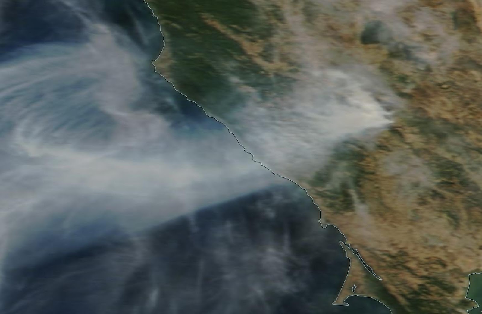
The situation Sunday morning (see below) is extremely concerning. The cold air has strengthened and moved east and south, creating very large pressure gradients, and thus strong winds, over the Sierra Nevada and northern California. The perfect set up for strong easterly/northeasterly dry winds over the region...known as Diablo Winds. I have an NSF grant to study these winds and have written a few papers on the subject...so this is of great interest to me.

Let's look at the latest high-resolution WRF model forecasts over northern CA made by the Desert Research Institute CANSAC group. This figures will show sustained winds--gusts are 30-50% larger.
The event begins around 11 PM Saturday, as strong northerly winds push southward into the Central Valley and easterly winds begin to rev up on the western slopes of the Sierra Nevada.

Six hours later, all hell is breaking loose. Sustained winds of 50 mph or more are found on the western slopes of the Sierra Nevada and on/downstream of some of the higher crests of the terrain north and east of San Francisco (such inthe Sonoma County area in which the Kincade fire is burning). The strong winds are found in regions of acceleration associated with mountain waves.


PG&E will have little recourse but to de-power a large region and that must include the high-voltage, high tension towers. A failing tower caused the Camp Fire last year and appears to have initiated the Kincade wildfire this week.
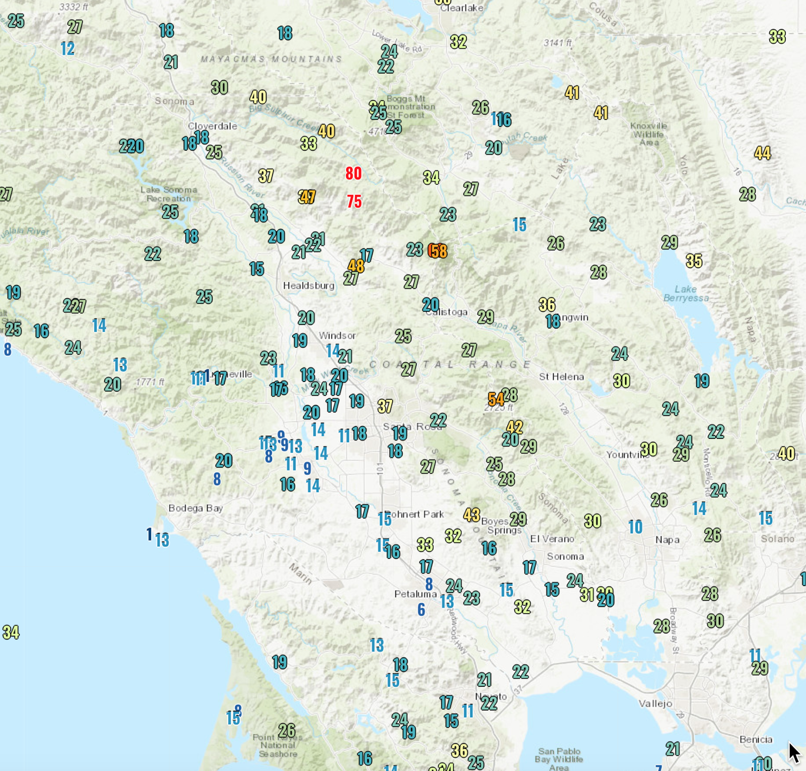
One good thing is that PG&E has added hundreds of surface observation sites that provide an extraordinary view of the winds in the region. To illustrate, here is the maximum gust map for Thursday, north of San Francisco. Lots of observations--and you can see the strong winds (75 and 80 mph) associated with the Kincade fire. Not how winds change very rapidly in short distances. Very valuable.


CA has descended into the Dark Ages. The governor wonders why they have the highest gas prices in the country, the legislature wonders why builders won't construct more housing, and so yawn.
ReplyDeleteWe are very fortunate up here in the NW that major offshore wind events are rare, and when they do occur it's nearly always during seasons when fuels are still moist. If we ever had a strong mountain wave event after a period of hot dry weather we could potentially see similar fires to what they face in California.
ReplyDeleteThat wind storm just tire through here in Kelowna BC. Major power outages
ReplyDeletePretty darn windy over here in eastern Washington. I can't see more than two miles because of all the dust it's really bad and still getting worse
ReplyDeleteDust in the wind,
DeleteAll we are is dust in the wind ......
After all these years, the rock band Kansas is still around. And the small hamlet of Dusty, Washington, isn't named Dusty for no reason.
Anyway, an opinion has been around for some time now that the Blue Mountains of southeastern Washington and northeastern Oregon aren't mountains at all.
The Blue Mountains are in fact gigantic heaps of compressed tumbleweeds.
This is a really interesting problem to try to solve for CA and for PG&E- so, Cliff- if resources weren't an issue, what would you need to build a robust predictive model that could help the utility make more precise decisions? Sensor density, meteorological info, etc? Is such a thing possible? And on what timeframe?
ReplyDeleteSome surprise thunderstorm action in North King county this evening. Must be related?!
ReplyDeleteVox has had some good articles lately on the CA fires and how to fix the problems. Its an expensive complicated mess. Hopefully this is not WA states future.
ReplyDeletehttps://www.vox.com/energy-and-environment/2019/10/16/20910947/climate-change-wildfires-california-2019-blackouts
https://www.vox.com/energy-and-environment/2019/10/22/20916820/california-wildfire-climate-change-blackout-insurance-pge
You reference "Diablo winds" in Northern California. When I lived in Southrn California, we called them "Santa Ana's". Are these the same winds or different? Regardless, even as a child, I detested these winds because they were strong, loud, dried out the air so much, and reminded us it was Fall. Now in PNW, I continue to wonder why power lines are above ground anywhere other than it's cheaper for power companies. If underground, these ignition fire dangers wouldn't exist. Some money is needed to upgrade our infrastructure significantly in both regions.
ReplyDeleteWikie says: "The name "Diablo wind" refers to the fact that the wind blows into the inner Bay Area from the direction of Mount Diablo in adjacent Contra Costa County …"
DeleteYou should go read that article.
Underground electric lines, if large, require cooling -- so I've heard.
Guess you can look that up too.
They are similar winds, just a different name for strong winds that blow offshore. Yes, it's cheaper for power companies (and therefore consumers) to not bury transmission lines. The transmission lines they refer to are carrying 250,000 volts and can cost as much as 5 million per mile to bury. Those costs are staggering.
DeleteSanta Ana's are winds affecting the Sierra Nevada's in Southern California, these are winds in Northern California. But same principle.
DeleteAs far as power lines; in nearly every case, these are high voltage feeder lines that are almost always above ground. The Sonoma fires a few years back were local distribution, but the fire started on rural private property.
Ward, same here. I live in Bellevue and we got some crazy stuff, along with some really loud boomers that literally shook our house like an earthquake. We actually got two storms and the smaller, earlier storm brought hail but no lightening. The second one just brought crazy rain that flooded out streets. Cliff, any reasons why? Or just a really exciting coincidence?
ReplyDeleteI commented at WUWT. A bit old now.
ReplyDeleteSaturday afternoon, about 3, a pulse came through -- dark, windy, & cold, with a sprinkle.
20 minutes later the sun came back and the winds dropped.
Airport (KELN) went from 11 mph to gust about 25. They will catch up in 10 minutes with the passage.
I was born & raised in SoCal and like derpswiwa - DETESTED the "Santa Ana winds" that emanated in the Great Basin - & - were horribly HOT & DRY - & - blew dust n' dirt and felled trees - and dried out your skin so it felt like that of a lizard. To answer derpswiwa's query re: "Diablo" v. "Santa Ana" winds ... "Diablo wind" is a name that has been occasionally used for the hot, dry wind from the northeast that typically occurs in the San Francisco Bay Area of Northern California, during the spring and fall. The same wind pattern also affects other parts of California's coastal ranges. The term first appeared shortly after the 1991 Oakland firestorm, perhaps to distinguish it from the comparable, and more familiar, hot dry wind in Southern California known as the Santa Ana winds. In fact, in decades previous to the 1991 fire, the term "Santa Ana" was occasionally used as well for the Bay Area dry northeasterly wind,[1] such as the one that was associated with the 1923 Berkeley Fire.[2]
ReplyDeleteThe name "Diablo wind" refers to the fact that the wind blows into the inner Bay Area from the direction of Mount Diablo in adjacent Contra Costa County, and mindful of the fiery, romantic connotation inherent in the term that translates to "devil wind". The Diablo wind is created by the combination of strong inland high pressure at the surface, strongly sinking air aloft, and lower pressure off the California coast. The air descending from aloft as well as from the Coast Ranges compresses as it sinks to sea level where it warms as much as 20 °F (11 °C), and loses relative humidity.[3]
Because of the elevation of the coastal ranges in north-central California, the thermodynamic structure that occurs with the Diablo wind pattern favors the development of strong ridge-top and lee-side downslope winds associated with a phenomenon called the "hydraulic jump".[4] While hydraulic jumps can occur with Santa Ana winds, the same thermodynamic structure that occurs with them typically favors "gap" flow [5] more frequently. Santa Ana winds are katabatic, gravity-driven winds, draining air off the high deserts, while the Diablo-type wind originates mainly from strongly sinking air from aloft, pushed toward the coast by higher inland pressure. Thus, Santa Anas are strongest in canyons, whereas a Diablo wind is first noted and blows strongest atop and on the western slopes of the various mountain peaks and ridges around the Bay Area.
In both cases, as the air sinks, it heats up by compression and its relative humidity drops. This warming is in addition to, and usually greater than, any contact heating that occurs as the air stream crosses the Central Valley and the Diablo Valley. This is the reverse of the normal summertime weather pattern in which an area of low pressure (called the California Thermal Low) rather than high pressure lies east of the Bay Area, drawing in cooler, more humid air from the ocean. The dry offshore wind, already strong because of the offshore pressure gradient, can become quite strong with gusts reaching speeds of 40 miles per hour (64 km/h) or higher, particularly along and in the lee of the ridges of the Coast Range. This effect is especially dangerous with respect to wildfires as it can enhance the updraft generated by the heat in such fires.
While the Diablo wind pattern occurs in both the spring and fall, it is most dangerous in the fall, when vegetation is at its driest.
Wonderful explanation of Diablo winds. Just imagine if we could lasso the power of such events for energy use, Wow! I have a son living in the Bay area so I have been doing my mom thing: warning him and worrying about his safety.
DeleteWe were driving when the hail hit in Seattle. The wind had really picked up as we exited a store, then the very hard rain followed as we got in the car. Surprisingly, the hail seemed to dump on us as though a hatch had been opened in the sky directly above us. We just looked at each other like what's next.
ReplyDeleteIt reminded me of going through a super-automated car wash combo theme park ride, but it was mother nature. It all happened so fast and was so very extreme! A definite "wow" experience in its intensity. Then, we motored home like nothing had happened.
Trying to use a name rather than be "unknown." Can't seem to find a way to create and activate a display name in my Google Account.
ReplyDelete