National Weather Service personnel are considered critical personnel and are still working, but they are dependent on numerical weather prediction models, which in turn are dependent on the quality and quantity of weather data going into them.
And it appears that one important data source is declining rapidly in volume, aircraft observations.
And such observations are particularly important for the West Coast of the U.S., which has a vast ocean to our west.
To produce a numerical weather prediction, a three-dimensional description of the atmosphere needs to be created, something called the initialization. Over land there are lots of surface observations and balloon-launched weather observations (radiosondes), but obviously there are far fewer of these over the ocean. In the old days of numerical weather prediction, forecast skill was less downstream of oceans because of the large oceanic data voids.
But this situation changed profoundly with the advent of weather satellites and the use of weather observations from commercial aircraft. The oceans now had substantial numbers of observations, driving a rapid increase of weather prediction skill. Weather satellites are now the dominant source of oceanic weather information, but aircraft observations (known as ACARS observations or AMDAR) are quite important.
The distribution of aircraft observations in January 2020 is shown below (courtesy of the the European Center --ECMWF). The number of observations is shown by the colors (red and orange are the most). Importantly, the are a large number of observations between the West Coast and Hawaii, most of which are at important jet stream elevations (30,000 to 40,000 ft). There are also considerable number of observations from flight going between North America and Asia.
As noted by this graphic from ECMWF, the number of aircraft observations has grown rapidly due to more flights and increased numbers of aircraft with the appropriate weather sensors.
A number of studies have examined the importance of aircraft observations for weather prediction. As illustrated below, automated aircraft observations (AIREP) are about fourth in importance overall (more important than surface observations!), and data denial experiments at ECMWF, in which they reran forecasts without using the aircraft observations) indicated a decline of forecast skill in the upper troposphere (again roughly 30,000 to 40,000 ft) by about 10% and some degradation near the surface (by roughly 3%).
Not the end of the world, but significant. But what about regions downstream of oceans? Could the impact be larger? That is an analysis I have not seen.
But there is a problem, particularly for us on the West Coast for short-term forecasts and for the entire nation in the longer term. There is a huge decline of air travel going on now. And the decline in air travel is about to plummet.
Hawaiian Airlines will soon cancel most of its flights to the mainland, and Alaska is planning on pausing on about 70% of its flights (some to Hawaii). Flights to Asia are down profoundly already. The latest statistics from the FlightAware website indicates nearly 16,000 flight cancellation today, with nearly half cancelled out of San Francisco and about a quarter at SeaTac and LA (red colors below). This is only the beginning.
So how much degradation in forecasts will occur as aircraft observations profoundly decline? To what degree will the impacts be greater for land areas downstream of oceans?
Considering the key role of satellite observations, one might expect the degradation to be modest, but perceptible.
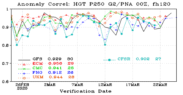
The latest forecast skill statistics over the Pacific/North American area (called the PNA region) available from the National Weather Service for the five-day forecast of near jet stream level (see below) does not suggest anything significant at this point (particularly since there is a lot of natural variation in forecast skill). In this plot, 1 (top) is a perfect forecast and several forecast models are shown (black--US GFS, red-European Center, green-Canadian), orange-UKMET).
Aircraft in flight at 9:30 AM this morning (from the wonderful FightAware site). This is already well down from normal, but a lot more than will be flying in a week
In the longer term, the impacts on weather prediction will be substantial for other reasons. Weather research and communication is being profoundly degraded. Major meetings and conferences have been canceled (including the NW Weather Workshop) and research is made difficult and far less effective. We are all trying to work at home and use online communication, but the degradation is real and will increase with time.


NWAC, working out of NOAA at Magnuson Park, has suspended avalanche prediction and halved the frequency of their mountain weather forecasts.
ReplyDeleteI don't suppose sending out weather air craft-- like hurricane hunters but just for general forecasting-- was in the stimulus plan.
ReplyDeleteSo true. This situation is so surreal. Hardly anyone living today has seen anything like it. The last time there was anything similar was the 1918 Spanish Flu. Let's hope we can arrest this problem soon.
ReplyDeleteCliff,
ReplyDeleteI completely took the additional benefits of these flights for granted. Thanks for bringing it to our attention.