As the models have been signaling for days, air quality over western Oregon and Washington has improved dramatically over the past 24 h, with much of the region enjoying relatively clean air (green colors on the map below). Clean air is surging over the Cascades and should soon displace the smoky air over the NW side of WA and northern Idaho.
As shown by the plot at Seattle, the rapid decline in particulate levels started Friday evening, with plummeting values overnight as western winds (winds from the west) strengthened.
The improvement in air quality is the result of a significant change in circulation, with high pressure to the southwest and modest westerly/northwesterly flow pushing clean Pacific air into the region. The forecast map for the flow at approximately 3000 ft valid at 5 PM today, shows the story.
There is some residual smoke out there (see satellite image from yesterday) that will move inland during the next few days: but not enough to push us into unhealthy levels. The smoke is that hazy area over the SW side of the image.
The disturbance that led the transition to our clean air brought the first real rain in a long time to our region (see 24h totals ending 8 AM Saturday below), with a number of locations getting a quarter to a half inch. We acutely needed the precipitation.
One issue of concern is that there were a number of thunderstorms embedded in the showers, with copious lightning over the Cascades and western Oregon. Lightning that could initiate new fires.
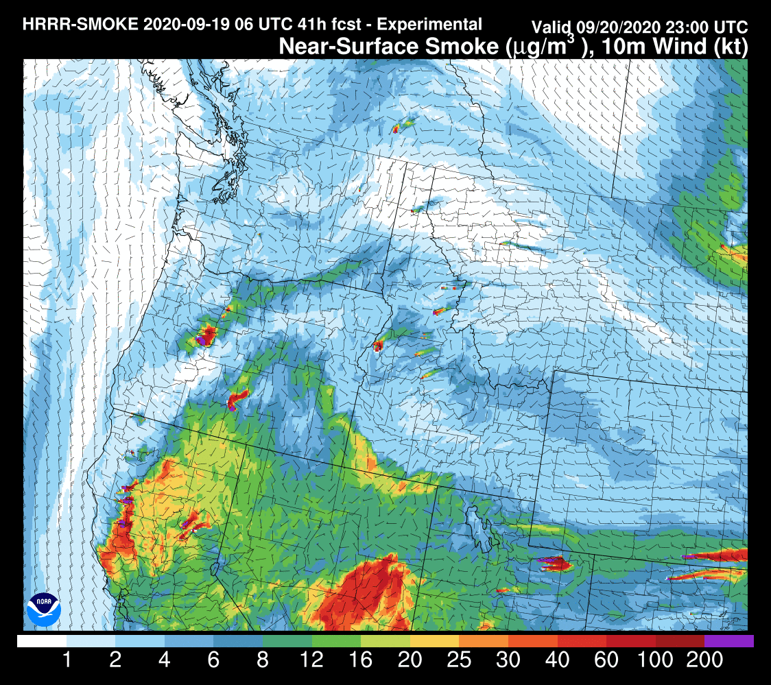
The latest HRRR-SMOKE forecasts (below) project improving conditions at 2 PM today, with serious smoke limited to NE Washington, Montana, and California.
By Sunday at 4 PM, even Idaho and Montana are clear. But the remaining fires in both Oregon and California continue to produce serious smoke for those downwind.
For those of us in western Washington, we are probably done with serious smoke for the season, but in California the end is not in sight.
______________________________________________________
My latest podcast:
Stream the podcast from your favorite services:
KNKX and Cancel Culture is found here.


Thank you, Cliff - this blog was the first thing I checked this morning so I would know for sure if I could finally get outside and get a walk in!n You have been very diligent in tracking the smoke and I appreciate it.
ReplyDeleteAn incredible thunderstorm came to Port Orchard yesterday and sort of parked there for a while. In the half hour from 5:35 to 6:05 p.m. we got .82 inches of rain and 1 inch total from the whole thing. The power went off briefly after a lightning strike. One struck almost overhead. The ozone smell was so strong and lingered for hours afterwards.
ReplyDeleteHow can fire.airnow.gov/ smoke map show about 8 smoke plumes over Seattle while all ground sensors shoe "Good" air quality (green)? Thanks, Rob
ReplyDeleteWow, first green AQI in 13 days. I never experienced anything like this in living here for almost 20 years.
ReplyDeleteIs there any way to tell how much of the clearing of the air is due to advection versus removal by rainfall?
ReplyDeleteHoping for an update on the incoming weather, looks wet.
ReplyDeleteCliff, I appreciate your analysis of weather, but I wish that you would stop harping on how any particular recent weather-related impact, such as the series of recent wildfires, is not attributable to Climate Change. Of course, no particular event is attributable to Climate Change. This is the difference between weather and climate.
ReplyDeleteYou just give succor to people who wish to ignore our cumulative impacts of burning fossil fuels on climate.