My Weekend Podcast Should be Online by 9 AM Tomorrow (Friday)
_______________________________________________________________
Atmosphere rivers are strong, relatively narrow currents of enhanced moisture that stream out of the tropics or subtropics into the midlatitudes. And when they extend into our region and are forced to rise by our terrain, they are potent precipitation producers.
Atmospheric moisture can be observed by weather satellites by sensing the radiation emitted by water vapor, producing information and beautiful graphics like the one shown below for earlier today (Thursday). You will note that the greatest amounts of water vapor is in the tropics (purple and dark red colors), which makes sense since warm air can pick up lots of water vapor from the tropical ocean.
But look carefully-
-can you see the narrow tendrils of moisture extending northward?
These are atmospheric rivers, and I have indicated two with arrows. The white arrow is the first atmospheric river, the one that has influenced us over the past 36 hours. That "river" produced a lot of rain, as shown by the precipitation total for the 36 hr ending at 3 PM today (see below, click to enlarge).
Some locations received 4-7 inches of rain during the period, such as on the southwest side of the Olympics, the region around Mt. Saint Helens, and the NW Oregon Coast. Even eastern WA and Oregon enjoyed some precipitation.
The second atmospheric river is rapidly approaching from the west and it has our name on it! As seen in the first picture above, this atmospheric river begin in the western Pacific, many thousands of miles away from us, and then swung towards the east, a behavior quite common this time of the year.
A recent water vapor image (6 PM) shows water vapor streaming towards the Northwest (see below)
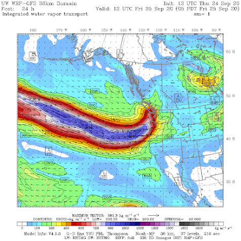
Let me show you a new graphic never seen before in this blog: the integrated water vapor transport. Drop that name to impress your friends. This graphic shows how much water vapor is being moved by the atmosphere. A strong atmospheric river with powerful winds and lots of water vapor has substantial water vapor transport. And it is a good measure of the ability of an atmospheric river to dump lots of precipitation on our region!
The water vapor transport at 5 AM Friday morning is impressive, with the blue colors indicating very large amounts. The arrows show the direction of the water vapor motion. Have your umbrella handy.
The expected rainfall is substantial. For example, the predicted 24-h totals ending 5 AM Saturday will reach 2-5 inches over terrain and rain will fall everywhere except around the dry zone from the TriCities to the Columbia.
Importantly....I mean very importantly, western Oregon is going to receive substantial rain (see below for same period). Wildland firefighters have been making major progress on the Oregon fires....this rain will enable them to make great progress. But there are concerns of ash and debris flows as the heavy rains starts moves the fire debris.
________________
My latest podcast:
Stream the podcast from your favorite services:
KNKX and Cancel Culture is found here.


How is Sunday looking? I was hoping for some time for a long bike ride without heavy rain.
ReplyDeleteHi Cliff, any details on the sequence of pretty impressive typhoons in the pacific that are making their way to Northern BC/Alaska and the impact on our forecasted warm/dry weather next week?
ReplyDeleteThey're not typhoons anymore once they reach the mid- latitudes they are extropical cyclones. A good friend of mine who was a pilot for Cathay Pacific told me alot depends on where the former typhoons go once they become extratropical. If they go into the mid North Pacific (closely following the route the airlines take coming from Asia) they often get hitched by the westerlies and come at the West coast either northern BC or the Pacific NW. But if the former typhoons go north of Japan off the coast of Russia toward the polar regions, they create a jet streak in the polar jet which basically causes that jet stream to buckle which will create a deep low in the Bering sea which,in turn,pumps up a big West coast ridge and we get warm and dry. That was our early September this year. The last few runs of the GFS has shown some potent storms in the north Pacific after the ridge pattern breaks down. Maybe old typhoon moisture in there?
DeleteCliff-- can you repost that 36 hour rainfall graphic please? I have been clicking on it and it won't open up. In other words it doesn't allow you to click on it...it's not a link. Thank you
ReplyDeleteHey Cliff, any ski season predictions?
ReplyDeleteThis is like liquid manna from Heaven, after what we have been through!..I will now open my bedroom window--that faces East--and enjoy listening to the raindrops as they lull me to sleep...I love this time of year!
ReplyDelete