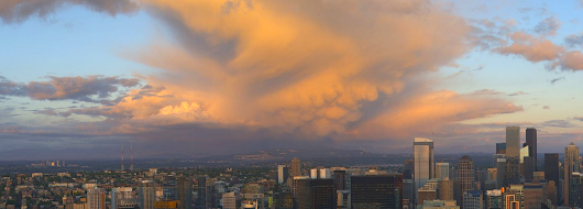
This is the season of large cumulus clouds over the Pacific Northwest. And they are often stunningly beautiful.
There is a reason why these majestic clouds are so frequent this time of year: the atmosphere is most unstable and turbulent during the spring, for reasons I will explain below.
And with strong sun and long days, the illumination is excellent, and the potential for rainbows ever-present.
Consider an image from the Seattle PanoCam for yesterday evening as the setting sun illuminated the underside of a large cumulus cloud east of Seattle. There is an extensive cirrus anvil-like structure aloft (with wispy edges) and downward protuberances called mammatus clouds extending downward from the anvil. These features are associated with heavier air that is sinking.
A few hours earlier, the PanoCam caught a growing cumulus cell south of Seattle with a shaft of rain falling beneath it.
And here is an extraordinary photo of a large cumulus cell over the South Sound yesterday taken by photographer Frank Jenkins. Beautiful cirrus anvil, made of ice. And an impressive shaft of rain reaching the surface.
Cumulus clouds, from shallow fair-weather cumulus to miles-high cumulonimbus (thunderstorm) clouds are known as convection and result from vertical instability. This generally occurs when a large difference with temperature with height occurs: when the temperature cools rapidly with height.
When temperatures cool sufficiently rapidly with height, a blob of air (called an air parcel), displaced upwards, will accelerate skyward on its own for a considerable distance. And surrounding the upward accelerating air, other air is moving downward.
You are all familiar with convection when you heat water or cereal in a saucepan (see below). Your burner is heating the bottom of the pan, causing a large vertical change in temperatures in the water or cereal, resulting in up and down motions: convection!
Image courtesy of Bruce Blaus
What time of the year does the temperature change most rapidly with height of the Northwest?
Spring!
Let me tell you why.
During spring, our sun is getting strong and powerfully warming the surface. Think of cranking up the hot plate shown above. Below is the solar radiation received in Seattle from January 1 to today. BIG increases over the past five months!
So we are warming the surface more intensely as we enter mid-Spring.
But the atmosphere aloft takes time to catch up....you can think of the atmosphere as a vast flywheel...... takes time to get it spinning faster!
Below are the temperatures at roughly 10,000 ft above Seattle from January 1st to May 18th this year. There has been only modest warming overall, and occasionally we get pulses of colder air (like at the end of the period). During these cool periods, the atmosphere aloft is cool, while the surface is vigorously warmed. This leads to a big change in temperatures with height, instability and convection.
You are living in the percolating atmospheric cereal pot during much of spring! And where the air is going up, there are clouds and precipitation. When going down, clear areas.
The early signs of cumulus convection are easy to spot: you will see the development of shallow cumulus like shown below. Many days that is all we get. But if the temperature change with height strengthens and there is a source of upward motion to get things going, more serious and taller cumulus convection may occur. Meteorologists like myself love such days.


I was hoping for pileus clouds with this pattern, but haven't seen any yet. A perfect topping for such days of instability.
ReplyDeletehey I saw pileus clouds today.
DeleteAren't those cumulonibus clouds once they anvil-out and produce precip?
ReplyDeleteThis is the time of year, when very localized showers can be seen happening maybe a block from your currently dry home!...I love the contrast of it all.
ReplyDeleteI love the instability of springtime in the Pacific Northwest.
ReplyDelete