The Pacific Northwest has a Mediterranean climate, with wet winters and very dry summers.
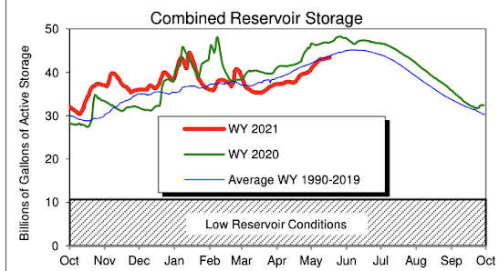
Thus, it is important for us to approach summer with full reservoirs, ample mountain snowpack (which provides melt water during the summer and early fall), and a nice late spring dousing to wet down the vegetation and soils.
And it looks like we will have all three.
As most of you know, we have had a dry spring so far, with the eastern part of the state receiving 0-3 inches less than normal and larger deficits in the west (as much as 9-16 inches below normal)--see below.
On the other hand, there is good news. With a relatively cool, wet, and snowy La Nina late winter the key reservoirs serving our region are looking good. The critical Yakima River reservoir system, so important to agriculture in eastern Washington, now possesses above-normal water levels (see below, blue is this year and red is normal).
Seattle's reservoirs are near normal and the snowpack above Seattle's reservoirs are above normal.
The current snowpack for Washington State is truly excellent west of the Cascade crest (287% of normal for the northwest Cascades and 152% over the Olympics) and above normal for the northeast slopes of the Cascades and the Okanagan area. But low snowpack is evident for the lower-elevation areas of southeast Washington.
Streamflow is near normal for rivers on the eastern slopes of the Cascades and those draining off the Olympics and northwest Cascades, but low flow is a concern over southwest Washington--the result of the dry condition during the past few months.
But good news regarding precipitation is on the horizon.
The latest UW WRF model accumulated precipitation forecast through Saturday morning shows wet conditions EXACTLY where we need it: over southwest Washington and in the Rockies that help feed the Columbia and Snake Rivers.
The wet bounty is due to the persistent development of upper-level troughs of low pressure over the eastern Pacific and the Northwest, as illustrated by the upper level (500 hPa) map of heights (like pressures) at 5 PM Thursday. Looks like a thunderstorm pattern to me!
Considering the skill of long-term summer forecasts is very poor, one needs to be careful about summer weather prediction. But in some sense, summer forecasts are less critical than winter projections, because the June through September period is so dry climatological around here. In any case, we are going into this summer in relatively good shape, even with the dry spring so far.


Might still want to stock up on smoke storm stuff anyway and reserve a few PTO days for when the air quality icon looks look a roasted raisin. Perhaps Cliff might post a re-run of what that entails.
ReplyDeleteDon't remind me! 😂😂. They failed to finish the job last year so who's to say they won't this year and force us all to live in centralized living in Portland or Salem?
DeleteThank you Mr. Mass.
ReplyDeleteOregon is in the Pacific Northwest and is way short of Washington for snow pack and soil moisture.
ReplyDeleteNope...Oregon is it's "own thing"...when you hear the name "Pacific Northwest", no one thinks about Corvallis!
DeleteWe are Oregonia now. We are NOT the PNW under the new climate model.
DeleteCliff, Michael DeMarco makes a good point. You did headline the post in terms of the Northwest, so I think it's reasonable to ask for detail about Oregon. You are extremely good at what you do, so you ought to consider such a request to be a compliment. You wouldn't be asked unless people respected you and your work.
DeleteLocation, location, location! The rain-shadow "banana belt" has a tougher 'go. Summers in the mountains (west side) haven't been quite so dry these last few years.
ReplyDelete"Looks like a thunderstorm pattern to me!"... Let's hope!
ReplyDeleteCliff, I thought we have a "maritime" or "marine temperate" climate, according to Koppen's classification system. Or perhaps "Maritime" and Mediterranean" are not mutually exclusive? If they are, what's the defining boundary?
This comment has been removed by the author.
ReplyDeleteThanks Cliff!
ReplyDeleteDo you think it's possible the dry spring we have been having is contributing to the large snowpack in the North Puget Sound region? The hypothesis would be that the normal rain we would get at middle elevations this time of year would melt the snow faster than dry or warm weather. Obviously there are a lot of variables such as tree cover, type of rain, etc.