The models have converged to a consistent solution, the storm is beginning to "bomb", and I can now provide a forecast with some confidence.
This will be the strongest Northwest storm on record, but its strength will collapse as it approaches the coast of Vancouver Island. More quickly than any storm in my experience.
And there will be strong winds over land, but not from the south, but from the east, as air is pulled westward by the immense, powerful storm offshore.
Let me begin by showing you the latest water vapor satellite image over the eastern Pacific (below), with the dark areas indicating dry conditions.
This is a very potent storm, with massive clouds and extreme darkening, which indicates strong sinking behind the low center (you can see the moisture curling up). Such sinking is a sign of vigor.
Both the American (GFS) and European Center (ECMWF) models indicate very rapid intensification over the next 24h, with the storm catching down to around 943 hPa (see below for 8 AM Sunday). This is a "bomb" cyclone, with the pressure dropping more than 24 hPa in 24 hours.
There has never been a storm this strong in the nearshore waters of our region.
The closest was 950 hPA in 1981.
Both U.S. and European modeling systems predict massive swell/waves approaching the West Coast from this monster storm, reaching 30 feet on Sunday evening!
Both modeling systems indicated that the storm will very rapidly weaken on Monday, making landfall on Vancouver Island with a central pressure around 985 hPa (see US model forecast below) at 11 PM Monday.
I don't think I have seen so rapid a collapse of a storm over water.
But what will happen overland? Will there be some strong winds?
The answer is yes.
Let me show you. The three stages to this unusual event.
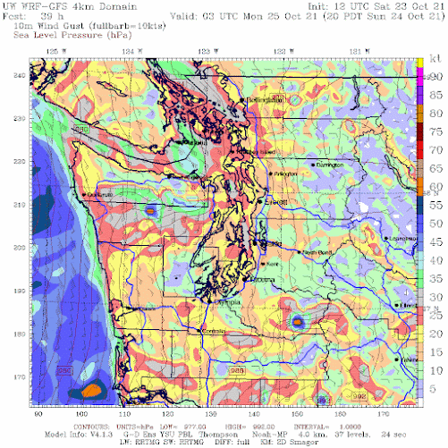
Stage 1: An intense low offshore and a large east-west pressure difference over the region
At 8 AM Sunday a huge, deep low center will be due west of the Columbia River outfall. The lines on the map are isobars, lines of constant sea level pressure. A very large pressure difference is over us, with lowered pressure to the west. In the presence of terrain, such a pressure gradient will produce very large easterly (from the east) winds in terrain gaps, and strong winds offshore.
Below are the predicted wind gusts at 11 AM on Sunday (in knots). Strong easterly gusts (to roughly 55 knots) in the eastern Strait of Juan de Fuca as the air in the Strait accelerates to the west, and winds will accelerate down the western slopes of the Cascades, with powerful gusts from Enumclaw to North Bend. Strong southeasterly winds offshore.
Stage 2. A Still Powerful Storm Moves Towards Land
Here is the sea-level pressure forecast at 8 PM Sunday. Just wow. An absolutely intense pressure difference over the coastal waters of Oregon and Washington. Very strong winds.
The predicted wind gusts at this time will be substantial along the coast, some reaching 60 knots (roughly 70 mph). Strong winds over the volcanic peaks and over portions of NW Washington.
Stage 3: The Weakened Low Moves North of western Washington
With the (weakened) low center northwest of western WA, there will be a substantial north-south pressure difference over Puget Sound and the Strait of Georgia (1 AM Tuesday is shown). That means WIND.
Winds will be strong, southerly, and gusty over the inland waters of Puget Sound, with gusts accelerating to 30-40 mph, especially near the water.
And don't forget the precipitation. California getting hit hard, with up to 8-10 inches through Tuesday morning (see forecast below). And there is going to be significant snow in the North Cascades and British Columbia this week.
Time to stop.....enough weather for a day!
My Podcast Has More Background Information on the Big Storms of the Northwest:
____________________________________________
The Second Edition of My Northwest Weather Book is Now Available!
My new book is greatly improved and expanded over the first edition, with new chapters on the meteorology of Northwest wildfires and the weather of British Columbia. A completely revamped chapter on the effects of global warming on our region. And it has been brought up to date with recent weather events and the imagery is improved greatly.
Where can you get it?
Or secure a copy from the publisher: UW Press.
And yes, there are online sellers like Amazon and Barnes and Noble.


Very impressive storm. You think you’ve seen it all, but Mother Nature throws curve balls now and the. Thank you for sharing Cliff and respect your analysis each week on the weather.
ReplyDeleteWe are going to be at westport tomorrow for high tide to watch the waves. Hope we aren't there too early and miss out! But should be a good time. :)
ReplyDeleteWhat time are you planning to get there? I think high tide is around 3 pm?
DeleteWe'll get there about noon'ish. Yes high tide at 3pm. Although largest waves (and storm surge) are suppose to be after 6pm.
DeleteSo the top two takeaways...
ReplyDelete- A remarkable storm regarding intensification, low pressure and weakening.
- An unremarkable storm regarding much of the Puget Sound and inland Washington and Oregon with the exception of the coast and the northern interior (even that's a stretch as a couple of moderate windstorms and wave action are quite normal this time of the year).
Hanukkah Eve...you still keep the title as the last historic windstorm to hit the area (15 years ago as of this December).
Question: Should resident at Ocean Shores move inland on Sunday, or will they be fine?
ReplyDeleteThank you for the extremely interesting explanation of what you are seeing. This now my favorite weather website!
ReplyDeleteFortunately there are no dramas happening in its path such as a crippled container vessel with a fire on board and the crew being advised to evacuate now anchored off of Victoria.
ReplyDeleteOh wait a minute - something about a boat called the ZIM Kingston?
I should gas up the generator, just in case! Thanks for the heads up. Let's all watch and see. Gotta love the weather here.
ReplyDeleteWow another crazy coincidence!
ReplyDeleteLikely related to the prior storm: https://www.msn.com/en-us/news/world/a-fire-broke-out-on-a-cargo-ship-after-about-40-shipping-containers-fell-overboard-due-to-rough-seas-off-the-coast-of-vancouver-island
ReplyDeleteIn response to William, yes, the lost containers off Neah Bay occurred during the Thurs/Friday storm, which created some big seas. The ship then came in and was ordered by the Canadians to anchor off Victoria, in the Strait. It was headed for Vancouver, BC. Other containers still on the ship contain chemicals that can self-combust, and have done just that.
ReplyDeleteLast I heard, crew had mostly abandoned ship and the Captain told the Canadians not to spray water on the cargo as they had other chemicals on board that will combust if they get wet. But water is the only way they normally fight a fire way up on top of a container ship -- shooting water up there.
This could end badly, and this storm certainly can't be helping the situation. Winds from the east and south-east today will push the dangerous fumes closer to the CA shore, but feel sorry for the folks west of Victoria on that side.
Why are these storms called "bomb cyclones?" Why not just call them hurricanes?
ReplyDeletethe phrase just refers to a storm with pressure that drops rapidly. Could be any storm.
DeleteHi Cliff As a suggested topic of interest, at least to me. I know we are all waiting for the BIG WINDS however I am also quite interested in an explanation in what seems like the BIG CALM that often seems to precede a storm. When I look at the graphs on WindAlert many show a pronounced dip/drop in recorded winds before starting to build. And the often increased temp/mildness that seems to accompany this period. I image all this is weather 101 info. Thank you
ReplyDeleteyawn. nothing has happened here
ReplyDelete