For the Northwest, November is the stormiest month of the year by almost every measure.
A month in which strong low-pressure areas or midlatitude cyclones move off the Pacific Ocean towards our region.
The next week is going to be extraordinarily active and it will be a miracle if western Washington or western Oregon escapes one of the big blows.
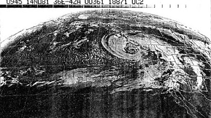
November is no stranger to major Pacific storms in the Northwest
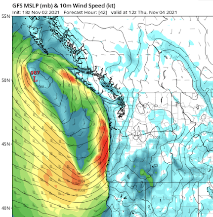
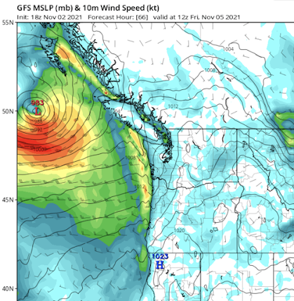
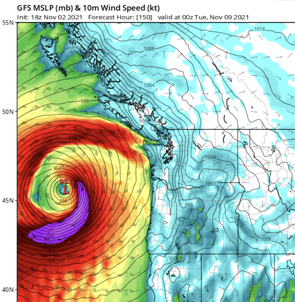
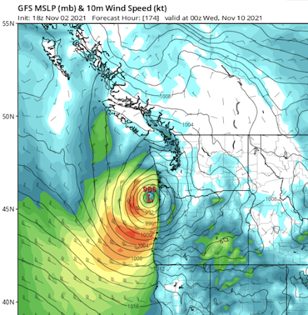
Let me show you the latest forecast from the most recent NOAA/NWS global model run. On these charts, you will find sea level pressure (solid lines), wind barbs, and wind speed (in knots) shown by the colors. These are sustained winds, averaged over several minutes, not gusts, which are much stronger.
This morning, a modest (994 hPa) low moved up the coast, with very strong winds along the northwestern shores of Vancouver Island.
Thursday morning (5 AM shown), another low moves up the coast, with an associated trough of low pressure bringing strong winds to the Oregon coast.
On Friday morning, ANOTHER low center approaches the BC coast, with strong winds on the south side.
And on Saturday morning, ANOTHER, relatively deep system is moving towards the Washington Coast, with powerful winds from Hoquiam southward.
The most impressive storm is just offshore on Monday afternoon, and it is VERY deep, with a central pressure of 951 hPa. Deeper than the famed Columbus Day Storm. Sustained winds of 50-65 knots. You don't want to know about the gusts.
And this system is heading due eastward, but fortunately weakening as it does so. Still, a major blow on the Oregon Coast.
One rarely sees so many storms reaching our offshore waters over a period of a week. But if it is going to happen, November is the expected month.
There is considerable uncertainty for the later storms, so keep tuned.
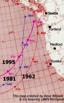
But with so much action, so close by, it would not be shocking if one of the storms moves into a favorable position to give Seattle or Portland a major windstorm. And so you know, to really gust around Puget Sound, one needs a strong low-pressure center moving southwest to northeast across the northwest tip of the Olympic Peninsula or the southern section of Vancouver Island (see examples below). If you see that, check your battery supply.


(Hey…what would it take for you to send a couple of those, say, 500 miles further south?) ;-) Thanks Cliff—an exciting November!
ReplyDeleteAny Sail Drones out in the North Pacific? It would be interesting to get some video and data on these storms.
ReplyDeleteHey Cliff…
ReplyDeleteThanks as always. When are we going to get some serious snow at the pass level in the Cascades?
In a word, yikes. Hope we just get the rain here, without all of the wind.
ReplyDeleteWould love to see more information about Eastern WA impacts.
ReplyDeleteHey Cliff - thanks for the insightful forecasts as always. Wondering if you can point me to a combined radar and satellite source for viewing. Accuweather used to have one but discontinued it for "lack of use" on line. MyRadar has a layer option for both but I can't seem to get the cloud layer to project. Any thoughts or suggestions?
ReplyDeletethanks!
Peter
Hi Cliff, I have a question about ridges and troughs. To me, the concepts of ridges and troughs require 2 dimensions (i.e., vertical and horizontal dimensions). But what are the dimensions for ridges and troughs?
ReplyDeleteWhen I look at an isobar map, it seems that a high pressure ridge and a low pressure trough are defined vertically by latitude and horizontally by longitude. But is that really all there is to ridges and troughs? Having latitude as the vertical dimension seems odd, because in that case, distinguishing between ridges and troughs would require us to assume that North is “up,” which would be a totally arbitrary assumption.
Am I missing some other vertical dimension that defines ridges and troughs? Maybe altitude? Thanks!
Will you be posting an updated forecast today?
ReplyDeleteIt would appear that the early forecasts about the next big Bomb Cyclone have petered out somewhat. Thank goodness.
ReplyDelete