After a relatively dry summer, the Northwest is experiencing one of the wettest autumns in a long time.
September and October brought above-normal precipitation around the region. November is going to smash typical monthly precipitation amounts at most stations.
Over the next few days, a powerful atmospheric river of moisture surging out of the subtropics will inundate our region, with the western slopes of some of our terrain barriers experiencing as much as 10 inches of rain. Falling on saturated soils, westside rivers will surge to flood stage...some to major flood stage.
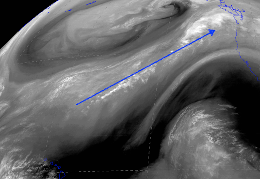
Water vapor satellite imagery (which measures the amount of infrared radiation emitted by atmospheric water vapor), shows an impressive plume of water vapor extending from north of Hawaii into our region. Perhaps a part of the "aloha spirit" that is not as welcome as others.
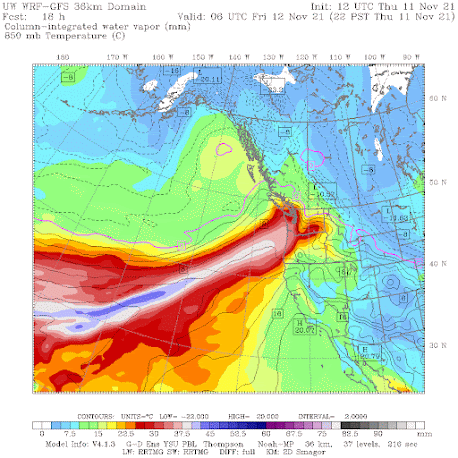
Model simulations of total atmospheric moisture in a vertical column (in this case for 10 PM tonight) show the potent moisture plume (see below).
Do you notice how the plume ends over our region?
Where did the moisture go?
You guessed it....into precipitation. Our mountains force the air to rise, wringing out the bountiful moisture of the atmospheric river.

The rainfall is going to be a mixed blessing. On one hand, the major reservoirs supplying Everett, Seattle, Tacoma, Portland, Columbia Basin agriculture, and Spokane are going to get major refill opportunities.
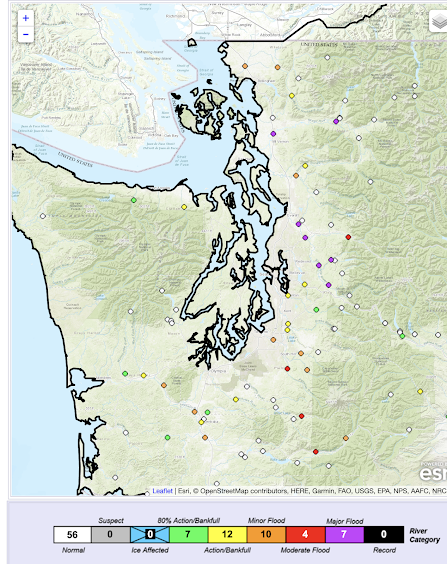
But the negative is that major flooding is expected on rivers draining off the western slopes of the Cascades, as indicated by the latest graphic from the NOAA/NWS River Forecast Center in Portland (see below). Purple colors indicate major flooding on rivers such as the Snoqualmie, Snohomish, and Skagit.
But this atmospheric river event is not the end of the weather action in our near future. ANOTHER major atmospheric river moves in on late Sunday and Monday, followed by much colder temperatures, and snow to our north.
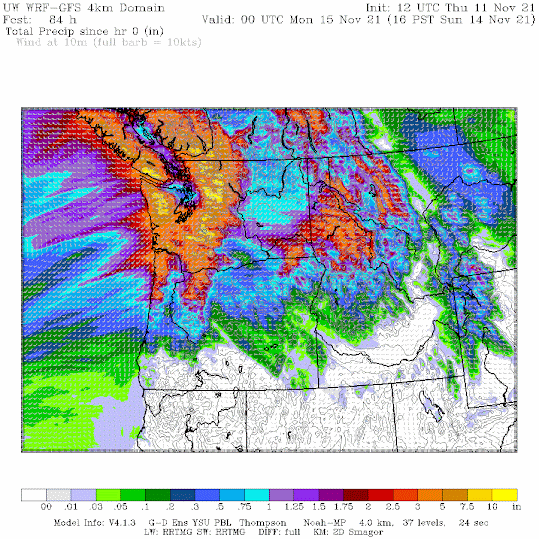
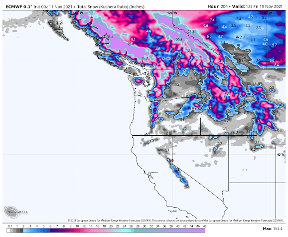
Models are now forecasting a massive snowfall in the mountains of southern British Columbia next week (see graphic). The amounts are off the scale. Whistler should be open for Thanksgiving.
______________________________________
Announcement:
I will be doing a book signing and dinner event at Ivar's Salmon House in Seattle on Wednesday, November 17th (6 PM). You can come just to purchase a book and get it personalized or you can stay for a special dinner, where I will be giving a weather talk. More information on the event is found here. You need to make reservations for the dinner (only 80 spaces available). And information about the new edition of my book is here.
Half the spot are now reserved, so if you want to go, reserve a place soon.
_______________________________________________
I will be doing a special online zoom session for the podcast/blog Patreon supporters this Saturday at 10 AM.


Great Job Cliff!
ReplyDeleteThank you Professor! This point in the calendar year strikes this layman as the peak in the differential: atmospheric stuff hitting one's balding pate per hour. Where clicks to forecasts are the byproduct.
ReplyDeleteThanks for clearly explaining atmospheric rivers.
ReplyDeleteIs this an I-5 corridor around centralia risk level event?
ReplyDeleteAgain, how much do we have to pay you to send these rivers 600 miles south of current track? ;-)
ReplyDeleteThanks for the great info, Cliff; have a great weekend!