We are about to experience the coldest weather since last February, with temperatures falling into the lower 20s over the western lowlands, with teens over eastern Washington.
We are about to transition between seasonal "warmth" and upcoming icebox conditions, so start preparing now--the transition is quite certain at this point.
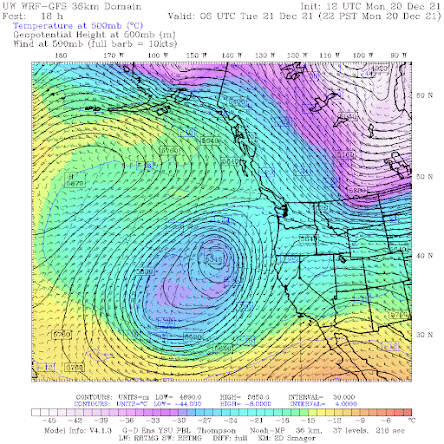
The upper-level pattern today (shown or 10 PM tonight at 500 hPa--about 18,000 ft) shows a very high amplitude wave pattern with a HUGE ridge of high pressure over the eastern Pacific and a deep low off northern CA. The coldest low-level air is now east of the Rockies at this point and temperatures over the Northwest are seasonal.
That is going to change.
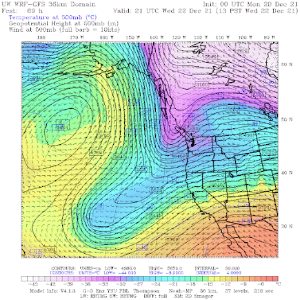
By Wednesday afternoon, a moderate upper-level trough pushes down over our coastal waters, bringing an initial pulse of colder air.
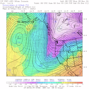
But December 24-25th will bring an even more powerful upper-level trough, that will push Arctic air across the region and the potential for lowland snow (not the italics). As shown by the upper-level map for 4 PM December 25th, a HUGE ridge of high pressure over the eastern Pacific...a La Nina classic. This is threatening.
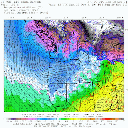
Now let's switch to the forecast surface weather maps, showing sea level pressure (solid lines, isobar), surface winds, and near-surface temperatures.
The situation at 4 AM on December 25th shows extremely cold air north of the border (purple is cold, brown is frigid, and white is off the charts), with modified Arctic air (blue) over northern WA. Strong, cold outflow will be moving into Bellingham and NW Washington.
And by 4 AM on the 26th, cold air will move southward into Oregon.
By December 24th, the region will be cold enough to snow to sea level, and the big challenge will be securing precipitation.
Our age-old problem for lowland snow lovers in western WA. We are generally mild and wet, sometimes we are cold and dry, but it is hard for us to be wet and cold.
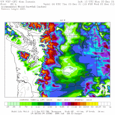
Here is the lowland snow forecast through 4 PM Wednesday. Plenty in the mountains and far eastern WA. Not much in the lowlands.
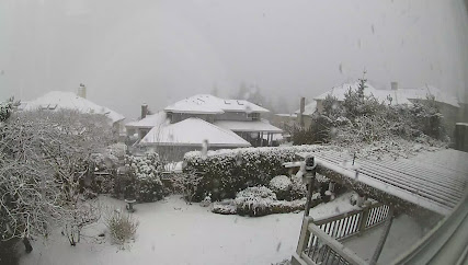
The freezingly level is fairly low right now (around 1300 ft), with some wet flakes down to sea level and accumulating snow above 1000 ft. To illustrate, here is a picture for a home at around 1000 ft in hills near Bellevue.
Picture this morning courtesy of Dr. Peter Benda
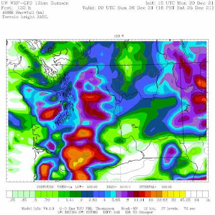
But now the fun. Below is the accumulated snowfall (not snow accumulation) for the 48-h ending 4 PM on Christmas Day. 2-4 inches over Puget Sound. But this solution/forecast is not stable....so keep tuned. The ensembles show substantial uncertainty.
So we could have a white Christmas. But temperatures and precipitation are on the edge-- so don't get your hopes up until we get a few ways closer. But you might stock up on hot chocolate and a good snow shovel...


Thanks for providing some forewarning Cliff! Has the most recent Euro model run (12Z) shown similar conditions? I noticed this article was based off of UW modeling (GFS).
ReplyDeleteYes, Euro is onboard with cold coming in mid to late Saturday and lasting for a while.
DeleteSanta better deliver! Let it snow!
ReplyDeleteSnowing right now in southwest Seattle! Not sticking yet, but looks to be proper snow falling rather than just sleet. Very pretty.
ReplyDeleteexert from King 5 news: With Christmas Day only five days away, do we have a chance at a white Christmas? Climatologically, it is about a 10% chance of an inch of snow on the ground at Sea-Tac (generally the definition used for a white Christmas because that is something that gets measured). And obviously, it is a better chance at places at higher elevations away from Puget Sound and north of Seattle. Often it is clearly not going to snow on Christmas day but this year there is a good chance.
ReplyDeleteAre any of the runs showing a possible snowstorm? Or are they all showing small amounts?
ReplyDeleteYes, it would qualify as a snowstorm for the Puget Sound. Anything over a couple inches is a disaster. The higher in elevation or further from the Sound the deeper the predicted snowfall amounts. 1-2ft as of now. Still a ways off, but the larger trend is very favorable for accumulating snow over a few days.
DeleteI'm a fan in E-Burg, east of the Cascades, can you include just a touch bit more E-Wa weather? Thank you, I appreciate the fine work you are doing, especially thumping "climate change" jay, whenever the opportunity arises.
ReplyDeleteCold in Spokane, according to his latest post
Delete