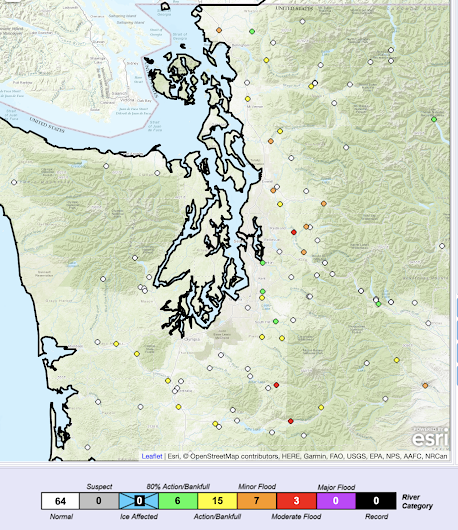
For those thinking that a lamb-like spring was coming early, think again.
Very heavy rain and flooding will be arriving on Monday, the result of a potent atmospheric river. Some locations in the lowlands will receive 2-4 inches on Monday, with twice that in "favored" mountain locations.
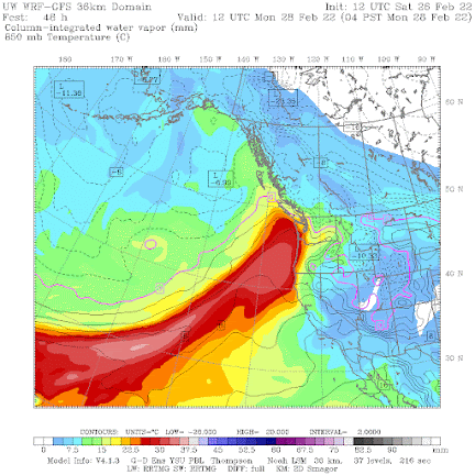
The origin of our wet future is a strong atmospheric river, a narrow region of large amounts of moisture, originating in the subtropics. To illustrate, below is a plot of total moisture from the surface to the top of the atmosphere at 4 AM Monday. As you might guess, the reddish colors are the largest amounts.
This atmospheric river starts north of Hawaii and heads northeastward right into our region.
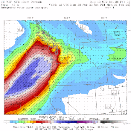
That is why meteorologists prefer to view integrated water vapor flux (IVT), an impressive-sounding term that actually means wind speed times water vapor. Just drop the term "IVT" in your conversation and your friends and family will be impressed!
Here is the plot of IVT for 4 AM Monday. The blue values are very high. A fast-moving river of moisture is heading straight for us.
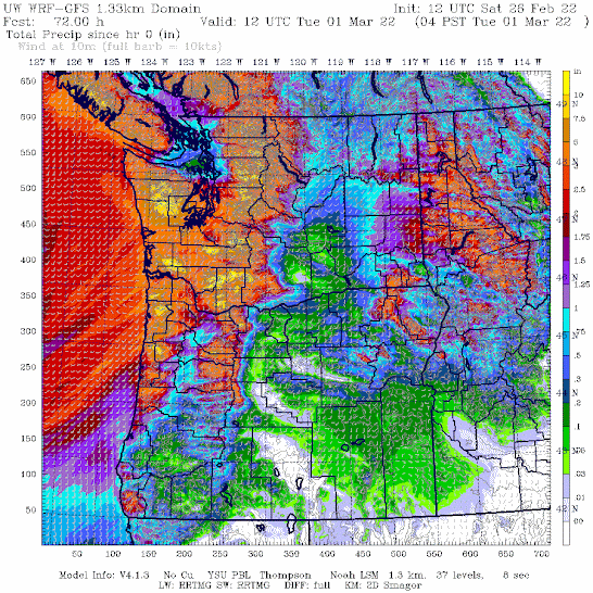
And when that river of moisture is forced upward by our regional terrain, an amazing amount of precipitation will be released. Consider the latest University of Washington high-resolution precipitation forecast for the total accumulated precipitation through 4 AM Tuesday.
Wow. 2-3 inches over Puget Sound and as much as 7-10 inches in the mountains. Profound rain shadow from Sequim to northern Whidbey Island.


Is it just me, or are there three different colour scales on these charts?
ReplyDeleteI can already predict the MSM headlines after this event is over - "Record atmospheric rains rapidly deplete an already diminished snowpack." Then it will drone on about the record warmth in February, the unexpected dry period, blah, blah, blah.
ReplyDeleteThe news has other distractions than a rainy day in Seattle.
DeleteWas February warmer than average?
ReplyDeleteAre three atmospheric rivers (so far) in one season normal?
ReplyDeleteNot unusual to have multiple atmospheric rivers in a winter
DeleteWe are supposed to drive home from Cannon Beach up the coast to Kitsap County tomorrow. Long mountain drive with two little kids in the car. Will it be safe to travel, or should we wait a day to be safe?
ReplyDeleteWell, you will have to deal with heavy rain at times....so it might be better to wait a day...cliff
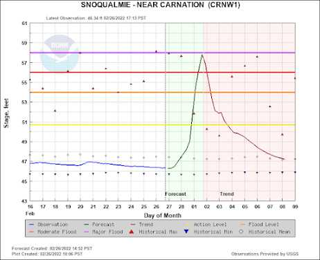
ReplyDeleteCliff, particularly with the most recent NWS forecast for Snoqualmie Pass for this past weekend, the NWS forecast seems to consistently under forecast the amount of snow (2-4 inches) on Saturday and all rain on Sunday. According to the Northwest Avalanche Center, 7 inches of snow fell on Saturday and 19 inches of snow Sunday through this morning (with the pass being closed this morning due to avalanche danger). Among those who work at Snoqualmie Summit, there is a general consensus that the NWS forecast seems to frequently get it wrong in terms of the amount of snowfall (under estimates) and the air temperature (over estimates). My general question is how are forecasts/computer models revised relative to actual results?
ReplyDelete