June 21, 2022

A Very Pleasant Heat Wave Ahead

Although the term heatwave has recently become a word that provokes fear and anxiety, a short, moderate heat wave can be very pleasant.

A time for swimming, icy drinks, and hanging out at a local park.


This week we will enjoy such a welcome period of warmth.  In a real sense, we are about to cross a meteorological rubicon from a cool/wet spring into mild/dry summer.

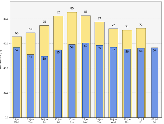
Below is the latest National Weather Service forecast for Seattle.   We have one relatively dreary day ahead (Wednesday), with a high of 65F.   Thursday is the transition day.  Friday will be in the mid 70s and Saturday through Monday will bring highs into low to mid-80s.


And after our "heatwave", there will be day after day in the 70s.

The warm period will be associated with the development of a moderate upper-level ridge along the West Coast, illustrated by the upper-level (500-hPa pressure level, about 18,000 ft) map at 2 AM Sunday (see below).


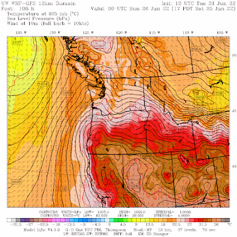
The surface map at 5 PM Saturday, during the first day of the warmth, has high pressure inland, easterly (offshore-directed) flow, a trough of low pressure extending from California northward into western Washington.  The classic warm pattern (the solid lines are sea level pressure and near-surface temperature is shown by colors).


This heat wave will be quite typical for this time of the year and will have little in common with the great heat event of late June 2021.

The latest extended forecasts suggest a profound change in the weather.

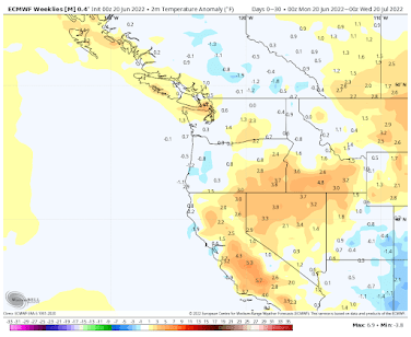
Temperatures over the next 30 days are predicted to be near normal  (see below)


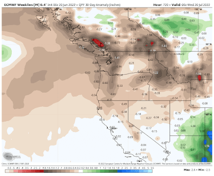
While precipitation for the next 30 days is forecast to be below normal for most of the region.


_____________________________

Announcement

   I will be giving a talk on Northwest Weather and signing copies of my updated book (Weather of the Pacific Northwest) at the Northgate (Seattle) Barnes and Noble at 1 PM on Saturday, June 25th.  


1 comment:

  1. My old stomping grounds Mt. Baker Beach right by the house I grew up in! Great memories

    ReplyDelete

Please make sure your comments are civil. Name calling and personal attacks are not appropriate.

The Storm Reveals Itself. The Eastside Wind Threat

The latest satellite image shows the rapid development of the offshore storm. The visible satellite image around 9 AM was stunning, with low...