Southern BC will soon be hit by unusually heavy precipitation for this time of the year.
And conditions before July 4th will be a damp affair, with a good chance of thunderstorms Saturday evening and Sunday morning.
Let me start by giving you the big view: the total predicted rainfall during the next seven days. The European Center accumulated precipitation forecast through 5 AM next Thursday (below), shows considerable rain.. as much as 2-3 inches in southern BC, with the North Cascades and northeast WA getting a piece of the wet action

The University of Washington modeling system's forecast is similarly wet. BC ducks will be happy.

The first big rain action will start Saturday night as an approaching upper-level trough forces a series of thunderstorms that will move northward out of Oregon.
The uber-high resolution UW forecast model shows the simulated satellite image at 11 PM Saturday (below). The most active thunderstorms will be over the Cascades and eastern WA, but western WA should get a taste of it.

The silver lining of the weekend rain is that the ground will be wetted down before all the firework activity on July 4th, reducing the potential for unintended wildfires and home destruction.
I should note that the cause of the weekend rain is similar to the origins of our wet spring: a persistent offshore trough of low pressure.
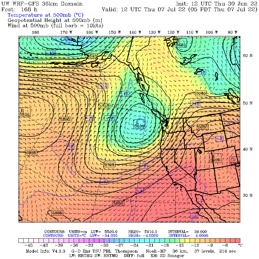
Here is the upper-level (500hPa pressure, about 18,000) map at 11 AM Sunday. A strong trough/low is centered just east of Oregon.

Next Thursday? The same feature is in place. This is a cool, wet pattern for us. And it is not going anywhere.
With a lot of rain over an already moist southern BC, wildfires there will be suppressed in that province through a good part of the summer.
This is very good news for us in Washington State. BC fires have been a major source of recent summer smoke.
But not this year.


Dr. Mass, you talked mostly about BC and the Cascades, but did you notice that localized dark streak on the WRF-GFS that angles SSE across Western Washington? The European Center models seems to show a feature of similar shape, but smaller in size and further north.
ReplyDeleteLooking more closely at the GFS Western Washington 24 hour map ending 5AM Monday (INIT: 12 UTC THU 30 JUN), it shows over 1" downtown, over 1.25" at SeaTac, and over 1.5" roughly around Auburn.
I know 4 days out is still borderline for confidence in rain forecasts, especially if they depend on thunderstorms, but if it turns out to be accurate, July 3rd could see its current record rainfall of 0.50" smashed, and we could see in a single day, twice as much rain as SeaTac normally gets for the full month of July.
Why is this keep happening. How come we can't get into our Summer pattern? The rain started last September and hasn't really stopped. Man we need a break...even if you love rain...what factors are contributing to this wet patterns. Why is that?
ReplyDelete