Last night and this morning, a front moved through bringing rain and gusty winds. As shown by the water vapor imagery on Saturday (below(, this front was tapping into a huge plume of water vapor stretching thousands of miles across the Pacific that has been present for weeks.

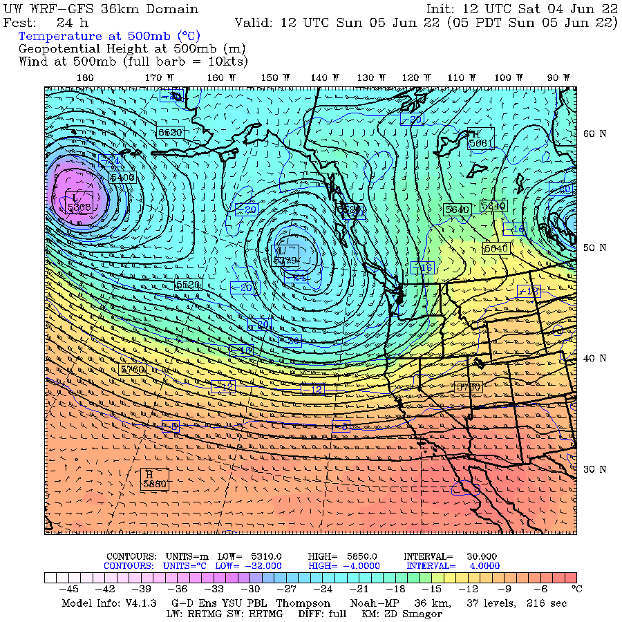
The key issue feature driving our cool, cloudy weather has been the existence of the persistent area of low pressure over the Gulf of Alaska (see the upper level--500 hPa/about 18,000 ft-- map for today at 5 AM below, the temperature at the level is shown by shading, orange/red is warmer).
With low pressure over the Gulf of Alaska and higher pressure in the subtropics, the result is a large change of pressure, which results in a strong western jet stream. Which brings in moisture from the west. The atmosphere is really like a big Rube Goldberg machine!
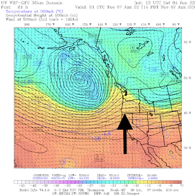
Fortunately, there will be a significant break on Tuesday afternoon as a modest ridge of high pressure builds over the region (see upper-level map below, with an arrow indicating the high-pressure ridge). You note the tongue of warm air moving northward over the West Coast.


Less Controversial Note:
I will be giving a talk and do a book signing at the Northgate Barnes and Noble in Seattle on Saturday, June 25th at 1 PM.


With all this rain are there any landslide risks?.
ReplyDeleteI noticed KING5 TV "weather reader" (advertised as a meteorologist) reported the same drought conditions once again on Friday's forecast. His report even was colorized into flaming red, orange and brown colors, the intent of which may have been to convince viewers "there's no hope."
ReplyDeleteI live about 8 miles from Baker City in NE Oregon. My rain gauge for the last 12 months is at 37". On a normal year it is less than 15" so we are way above normal precip this year. Even last year with the hot weather we still had average precip. Also our snowpack is at 240% of average. So one would think with all this additional rainfall we would be storing as much water as possible in our reservoirs. Yet a number of them have had the headgates wide open since early spring so nothing is being retained. Sure seems all political to me.
ReplyDeleteIt's actually the norm for our reservoirs to all have the gates open and be drawn way down this time of year - there will be an extraordinary amount of water going into those systems as the spring freshet comes out of the mountains and the snow melts. Reservoir levels will rise quickly and if they weren't already drawn down would risk problems from them being too full. They determine how far down to draw things based on the amount of water they are expecting to get from the snow pack melting, and given the current amount of water stored in the snow pack, I would be concerned if they didn't have the gates wide open at the moment.
DeletePBS News featured the dire water levels at Lake Powell, Lake Meed and the Hoover Dam. Apparently due to a 20 year drought effect. Is there any weather forecast that looks back long term 30-40 years to figure out what changed to bring about drought in Colorado River System?
ReplyDeleteThe most significant change over that period is how many PEOPLE are ladling water out of a river fed by snow melt that spends most of it's time in a desert. The area was a desert before the drought. It's not like it was lush environment. If the rain fall was 3 inches a year and the drought reduced that to 2 inches, what are we talking about? Building vast agriculture and large cities in a desert with no plan B. What could possibly go wrong.....
DeleteForgot to mention tropical tidbits daily enso updates has region 3.4 at -0.604 C as of today and rising.
ReplyDeleteI'll take our cool wet weather this year over drought & record heat in so much of our country. My tx cousin is looking at 105+ the net few days. As Alan Lacey wrote in his collection of garden essays, August in tx gardens is hotter than the hedges of hell. Now those hinges are heating up 2 months earlier than usual.
ReplyDeleteCliff, you are the one to tell the drought monitor guys to reassess. It is unlikely that they would listen to me!
ReplyDeleteIt wouldn't matter if Cliff did, they're in too deep with their politicized agenda to go back now.
DeleteSounds like tomorrow will be the day to mow the lawn.
ReplyDeleteThis is only a little off topic. Several friends have commented that the weather is sunnier and better than what the forecasts seem to be saying, especially a couple days ahead. I see two or three problems, as well as one suggestion.
ReplyDeleteThe proverbial 50% chance of rain can mean at least three things to most readers. One, that it is going to be rainy every where but only half the time. Two, that 50% of the area is going to be rainy, the other half not rainy. And three, it is going to be rainy everywhere but only a 50% chance. There likely are other understandings. Given weather systems and our mountains any or all of these could be involved. My suggestion is would it be possible to offer what the chances/percentages would be for at least a couple hours, morning, afternoon, or evening being nice enough to do outdoor activities? The one day ahead hourly forecasts do this fairly well, but the two and three day seems to do not so well.
Looks like a good year to dust off the green tomatoes recipes
ReplyDeleteIt's only June things will change in July mark my words
ReplyDelete