Welcome to monsoon season in the Northwest!

The moisture is associated with a plume of water vapor coming out of the southwest---a northwestern extension of the Southwest Monsoon (also called the North American Monsoon).
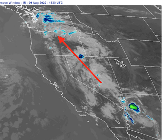
The water vapor satellite image this morning shows the moisture plume

as does the infrared satellite image.
The Southwest Monsoon occurs every summer from roughly late June through late August. It occurs as high pressure tends to build over roughly the New Mexico area, resulting in moisture being swept up from the Gulf of Mexico, across Arizona and western New Mexico, and then up across Nevada into eastern Oregon (see schematic below, showing upper-level heights at 500 hPa (you can think of this like pressure at 18,000 ft). The white area shows the direction of the flow at that level.


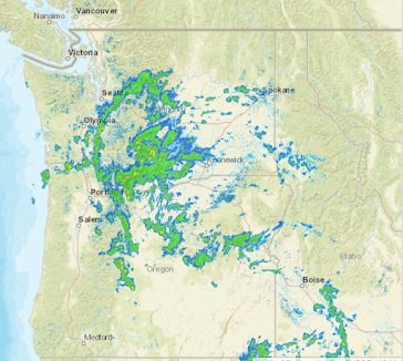
During the last 24 h (see below) the monsoon clouds/showers brought light rain into eastern Oregon, with some spreading westward to the Cascades. Here in Seattle, only about a trace.

24h precipitation ending 10 AM Tuesday
During the next 24 hr, more light showers will occur over the region as the low off California heads northwestward into our region. Below are the 24-h precipitation totals ending 5 PM Wednesday. You can see the showers swirling around the low offshore and more monsoon moisture heading up into eastern Oregon.

An interesting research question my group is working on deals with the implications of global warming for regional precipitation and particularly monsoon moisture. Our initial work suggests MORE summer monsoon precipitation over eastern Oregon as things warm up (see below). But we have a lot more work with higher resolution climate simulations to nail this down.

Differences in summer precipitation between the end of the 20th and 21st centuries. Green indicates more summer precipitation. These high-resolution climate simulations assume a massive increase in CO2 (RCP 8.5 scenario)....probably way too much.


Your climate models will never provide any significant nor beneficial data for as long as they fail to include all of the known effects that solar particle forcing processes are not included in said models. We are always one severe volcanic eruption away from erasing any warming, and which current climate models erroneously and maliciously attribute to anthropogenic sources. Prove me wrong.
ReplyDeleteThey literally plug that forcing in to all the climate models. Maybe do the research before daring people to prove you wrong
Deletehttps://images.app.goo.gl/XKfFnFKDwvYgngU18
"Prove me wrong."
DeleteNah, the onus is on YOU to prove the models wrong if you think they're wrong. Not the other way around. Where are the "correct" and "non-malicious" models and peer-reviewed papers backing your stance?
The climate models prove themselves incorrect 100% of the time. You probably have no idea what CMIP5 or CMIP6 is, and why those climate models are incomplete when it comes to the nearly 20 different ways solar energy gets integrated into the atmosphere. You also did not provide any studies, so how exactly do you win this argument? Here is a tip of an iceberg for you: https://www.youtube.com/watch?v=aUxuUGdqVH4
Delete@Qwerty: The channel you linked is called "Suspicious0bservers". You really expect us to trust what they say as fact over Dr. Mass, a respected scientist?
DeleteSure, OK, good luck with that. Your effort is admirable.
Wow. Well if we are one volcanic event away from erasing any warming, then we are also a thermo-nuclear war away from it as well. Or why not even say we are a planet killing asteroid or comet away from not having to worry about any of it, if we want to get crazy? Or, we could just stick with the facts, and use the data we have available and realistic scenarios to develop the modeling.
DeleteVolcanic eruptions have a shorter duration of effect than greenhouse gas emissions.
DeleteThe largest volcanic explosion in recorded history, the 1815 Mount Tambora Eruption caused cooling of around 0.5 degrees C. The cooling lasted 2-3 years.
The Salamas eruption in 1257 wasn't quite as powerful, but released more sulfur into the atmosphere. It's cooling effect is estimated to have peaked at around 1.2 degrees C in 1259, and lasted 4-5 years.
As most readers here probably know, the climate has warmed by about 0.8 degrees C over the course of the 20th and early 21st centuries, and is predicted to total 1.5-2.5 degrees by the end of the 21st century.
A major volcanic eruption would be unlikely to completely offset that warming, and the effect would diminish relatively quickly.
how common is it for monsoonal moisture to extend so far north?
ReplyDeleteSummertime "Rain" over here in EaWa is like a tiny sprinkler in the Sahara. Useless
ReplyDeleteYeah, pretty disappointing for anyone raised on eastern thunderstorms. It does happen- rarely.
DeleteThe NWS has issued a red flag warning for the peninsula due to the expected dry lightning and high winds. https://inws.ncep.noaa.gov/a/a.php?i=73663562
ReplyDeleteWow... The 2070-'99 model shows a decrease of 0.5-1.0 in. of Jun-Aug annual precip for the Seattle area. Hardly seems like we have that much to lose :(
ReplyDeleteAbout 9:45 a somewhat major lightning storm surrounds us. We overlook Sinclair Inlet. The thunder is pretty constant.
ReplyDeleteps It was preceded by a very heavy overcast, and we had to turn indoor lights on in our overly windowed condo.
ReplyDeleteDoes this have any effect on rainfall in the Colorado basin or the central valley.
ReplyDeleteThinking about past summers which seemed to have an inordinate propensity for thunderstorms, I wonder if this phenomena of the southwest monsoon being pulled into our area is one of those things that is not annual but a result of situations like the low pressure system here being positioned in just the right place. 1979, the late 1980s and 2012 are years I remember being notable for thunderstorms above average during summer.
ReplyDeleteI recall there were some thunder and lightning during those times especially in August here in Tacoma when I was still living at home at times. When I lived in Seattle from 1996-2016, some summers we would get spates of dry lightning in August, but we were closer to the convergent zone area and one summer in the evening, I was out on my balcony looking west from Capitol Hill when a dry lightning hit the area, missing Capitol Hill itself, but appeared to have been east of us for the most part.
DeleteOne situation was very vivid as it was in I think 1976 when a dry lightning storm rolled through Tacoma at around midnight and I was sleeping on the living room couch, the front window looked west and I was scared of the lightning when a good family friend of my youngest sister (sadly, both have since passed) sat and showed me how beautiful they were, and ever since, I have enjoyed thunderstorms.
There were exceptions when they were a bit too close for comfort, one was a couple of years later, the other was in the 1980's when a thunder cell came over our neighborhood in the west end of Tacoma (Skyline area), and again, we faced west and could see the Narrows Bridge from our deck and Mom was heading to a vestry meeting, Dad and I were standing near the garage door when lightning struck nearby and zinged the door's tracks right near us and a house across the street got hit.
Then there was the doozy in Sept of 2019 that hit Tacoma at 8:15pm, knocking out my power and several others in my area due to a substation having been hit in Hilltop, taking out one of the phases. Electricity was restored within a couple of hours. I have a video of it on YouTube.
Great post. Yesterday we experienced the most prolonged and intense lightning I've witnessed in my 32 years in Walla Walla. 4-5 t-storm cells trained over us between 5 and 10 pm. The dewpoint temp was 63* at noon, so I knew something was going to blow eventually...
ReplyDeleteCan you do a play by play of the set up for the thunderstorms from Wednesday. How many lightning strikes, how tall the CN clouds were? Any of anomalies. Thank you Cliff!
ReplyDeleteIn Tacoma, experienced the brief downpour yesterday morning and just before that, the lights flickered and we had a clap or two of thunder and a few flashes of lightning before the rains came in for about 5 minutes or so, and that was it for the most part of that. Remained cloudy though all day yesterday. The flickering of lights began near the end of my shower yesterday morning, the showers dropped between 9-10AM.
ReplyDelete