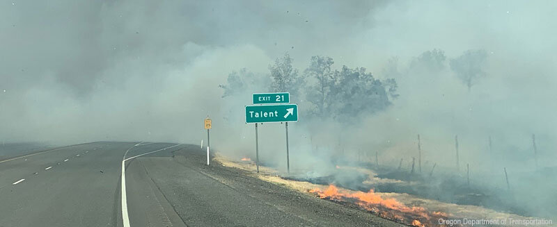
There is a serious wildfire threat for western Oregon and southwest Washington on Friday and Saturday.
Not the equal of September 2020, but serious enough that we need to be careful. This blog will describe the situation.
Historically, major wildfires west of the Cascades crest occur in August and September for two reasons.
First, the surface "fuels" are dry after our typically arid summers.
Second, this is the season of strong easterly (from the east) winds as cool air --and associated high pressure--begin to move into the continental interior. Air accelerates from the interior high pressure towards lower pressure along the coast. Strong easterly winds dry as they descend the western slopes of our regional mountains. Strong winds can initiate fire and stoke it.
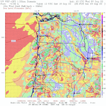
The USDA Forest Service created the Hot-Dry-Windy (HDW) index, which correlates strongly with fire growth. This index is essentially wind speed times a measure of dryness (called Vapor Pressure Deficit, VPD).
Here are the predicted values of Hot-Dry-Windy for 5 PM and 11 PM on Friday evening. Anything over 300 (green) is concerning. Anything over 500 (orange and red) is dangerous. The coastal mountains and the western slopes of the Cascades are problematic.


However, any preexisting fire (e.g., the Cedar Creek fire of the central Oregon Cascades) could explode. And we must be very, very careful not to start any fires, which could rapidly grow.
_____________________________


It would appear that PGE here in Portland has learned the hard lesson from the catastrophic fires from two years ago. They've already issued a statement that if there are any downed power lines during the wildfire threat, those homes within that area will have their power shut off immediately. Hope it doesn't come to that, because the intense heat naturally would dictate the use of air conditioners, but better safe than sorry.
ReplyDeleteWhat is the smoke forecast going to look like for this event. Will Fires at East pour smoke through the gorge and into Vancouver and Portland. I remember back in 2020 when smoke from the east side of the state billowed through the gorge and practically blocked out the sun.
ReplyDeleteThe fire is almost always in the West, isn't it? Historically, I heard that this was a Maritime or Marine Temperate (AKA, Oceanic) climate here in Western Washington (For example, Walter Rue's Book, Weather of the Pacific coast; Encyclopedia Britannica, with a map of the world climates, Koppen's Climate classification) But Cliff, you've been calling this a Mediterranean climate. A change?
ReplyDeleteWe have BOTH a maritime and Mediterranean climate. No change. It is as it has alway been. A med climate had dry summers and wet winters. A maritime climate is heavily influenced by the nearby water.
DeleteRegarding whether fires are mostly in the American West now, yes but that's because of fire suppression and coniferous deforestation of most of the rest of the lower 48. What little American forests exist now are mostly deciduous. By comparison if you look north of the border there are plenty of forest fires distributed west to east. https://www.americanforests.org/article/north-american-forests-in-the-age-of-man/
DeleteIn
Yes, deciduous tree don't burn as readily. But they have two other things going for them back East: Summer rain; and high humidity. Canada has more coniferous forests than New England, back in Quebec, and less tropical moisture.
DeleteWell Cliff....so much for no more heat wave events this year!...At least 90 predicted for this coming weekend...at least this event appears to be short-lived, but as you mention about smoke/fire issues, Mother nature seems to insist on punishing our "Maritime/Med climate!
ReplyDeleteThat first image of the hot-dry-windy index really helps me understand the huge Tillamook fires that occurred in the 30's.
ReplyDeleteI've spent a fair amount of time hiking and camping in the Tillamook forest, a significant portion of which is rain forest. I was really surprised to learn about the series of major historical fires there.
Your explanation of the factors that drive major fires west of the Cascades, and seeing those conditions forecast again in the Tillamook forest is eye-opening.
I'm betting we don't get that hot, considering the muted sunlight. But confound it, it is time for some proper rain.
ReplyDelete