A narrow plume of relatively dense smoke from the Bolt fire has been pushing into western Washington the last few days.
And today may be the worst of the period.
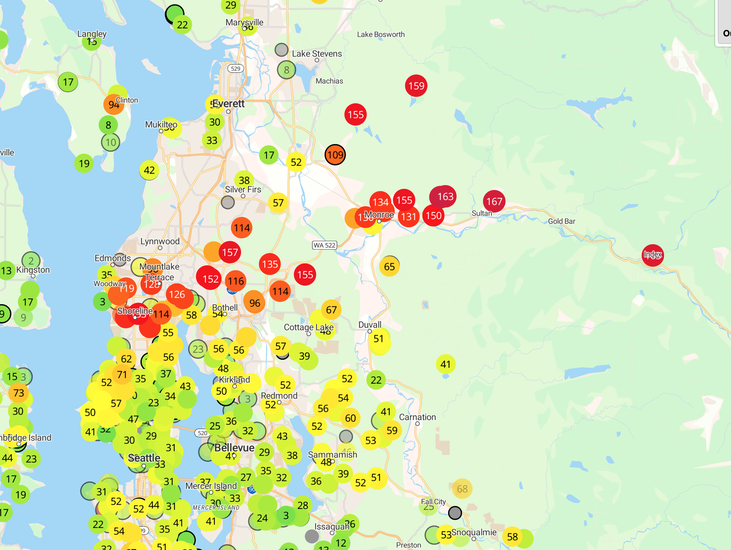
The 11 AM surface air quality network run by Purple Air shows the smoky air (red colors are the worst) moving westward out from Steven Pass highway into Everett and north Seattle. I can smell the smoke here at the UW.

The high-resolution visible satellite image this morning clearly shows the plume of smoke following through the relatively narrow Skykomish River valley and spreading out as it hits the lowlands.


Although not spread horizontally, the Bolt Fire is still smoldering and burning internally, producing significant smoke, as evident from WSDOT cams on Route 2.

The meteorology is interesting.
Cool air produced by the longer nights drains into river valleys (like the Skykomish) and then jets out into the lowlands, injecting the smoke into populated areas each morning (see plots of the amount of particles in the air above Monroe, WA the past few days). Later in the afternoon, increasing mixing by convective mixing (produced by surface heating) tends to dilute the smoke concentrations.

The meteorological "problem" is that we have a very weak pressure pattern over us right now, with little clean, onshore flow (see weather map for this AM, showing sea level pressure).

Tuesday won't be much better, but the pressure pattern should change on Wednesday afternoon, with much more onshore and northwesterly flow moving in.


I'd be interested to know why airnow.gov doesn't seem to have very good data. They listed south Everett as "good" this morning with a value of ~20 when it clearly was not. iqair.com seems more accurate today.
ReplyDeleteThank you for plugging this resource that is new to me - iqair. I too have been frustrated with airnow. It is now Wednesday and airnow is reading "good". When you can visibly see smoke, it is certainly not "good". So then I checked out this iqair - reading USG - obviously more accurate. I am in Olympia. I have to assume that either airnow lags behind in time, or the sensor has fresh ocean air blowing right on it or something. This is the value of people speaking their mind here. Cliff doesn't answer every comment, but it's also about us - the members of the public- sharing good resources with each other.
DeleteI live in Sultan and the air yesterday was very bad. Just returned home from a trip to Iceland, we've been watching this fire from afar for over a week. What drastic differences. Melting glaciers and abnormally warm weather of the north Atlantic to forest fires and intolerable air of the PNW. Our planet is being greatly affected by climate change, travel the world and it is easy to see. Forests and glaciers are being lost at such a fast rate and there is no sign of slowing. Hoping for some wind and rain and little relief.
ReplyDeletethe bolt creek fire probably little to do with climate change...
DeleteIt is understandable that individual events typically are mostly affected by micro variations (not climate change), and trends of averages are based on macro variations (climate change being one). Intuitively a lot of people are seeing the fire near Index as a part of a trend where fires are moving westward and it is hard to not directly correlate the most extreme example of the trend to climate change.
DeleteI don't remember a time where western Washington experienced a fire west of the cascades, especially not one of consequence. Maybe some future posts could be about the trend of fire locations so that we could see something on a more macro level? Or maybe you could provide a trend of the factors that correlate to fire starts and propagation along with a predictive model of fires? You could include this with a longer form discussion, based on climate models, of western Washington fire occurrence probability in 2030, 2050, and 2070.
The last large fire on the west side of Stevens Pass was the Evergreen Mt. fire in late August of 1967, which burned several thousand acres in the Beckler/Rapid River area.
DeleteEast winds were an issue on one day, but most of the fire growth occurred on a couple of light wind, very warm days when the fire blew up with a tall smoke column and spotting.
Tuesday morning here in Anacortes is warm. We are getting warm air out of the Frazer River. Quite the opposite of the dreaded arctic blasts in the winter. Currently 15-20 degrees warmer than in Mt. Vernon.
ReplyDeleteIt's about time we got some serious rain. What are the prospects?
ReplyDeleteI second that. Olympia is so dry! Any hint of a pattern change?
ReplyDelete