The last month has been considerably colder than normal over the region, with eastern Washington being particularly frigid. The coldest air this season will arrive on Sunday.
To put you in the proper mood, take a look at a plot of the difference in our daily temperatures from normal over the past month (see below). Eastern Washington has been frigid, with temperatures 6-12 F below normal, while western Washington has been 2-6F below normal.

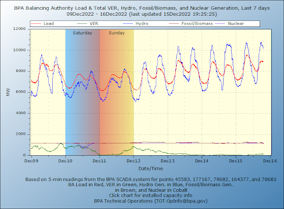
It is interesting to note that electric energy demand increases with the cold temperatures and that hydro is providing most of the energy (see recent Bonneville statistics below). Renewables (solar, wind) provide very, very little. It is important that when we need the most energy (when it is very hot and very cold) wind energy is generally minimal in our region.. One reason I strongly support nuclear energy development.

What about Eastern Washington? MUCH colder. At Pasco, for example, the temperatures will fall into the teens at night, and single digits will be widespread.
What about snow?

Our region will stay moderately cold and decidedly dry through Saturday.
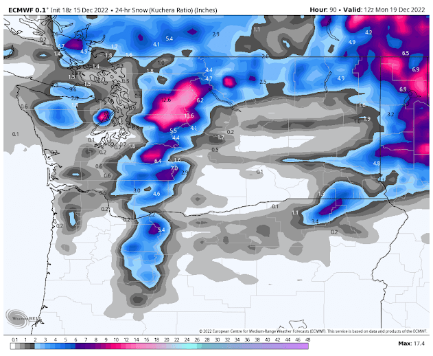
But on Sunday afternoon through Monday morning, cold air and high pressure will push southward from British Columbia, as illustrated by the surface chart at 4 AM Monday. (below). The lines indicated sea level pressure and the colors show the temperature at around 2500 ft above the surface. Blue, purple, brown and white colors are cold enough to snow.
Northwest Washington and eastern Washington are the coldest in our state at that time. Insane cold over the BC interior and east of the Rockies.

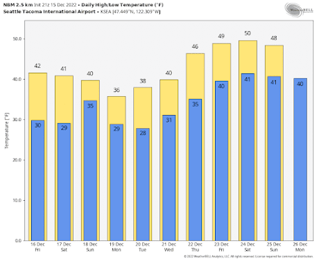
Here are the forecast temperatures at SeaTac Airport for the next week based on the NOAA/National Weather Service NBM prediction (which uses many models and data sources). Monday and Tuesday would have highs only reaching the mid to upper 30s and lows in the 20s.


This coming push of cold air will not have a lot of moisture with it (sorry kids).

 In any case, I will keep a close watch on the snow potential. And as we get closer, I will have more powerful tools available.
The first chance will be on Sunday as the cold air pushes southward. Here is the forecast for total snowfall through Sunday at 4PM. Some snow in the mountains and eastern WA, but only scattered snow in western Washington. Bellingham, the San Juans, and the northeast side of the Olympics are the best bets.

The snowfall from the lower-resolution European Center model (for the 24h ending 4 AM Monday) suggests the potential for a band of convergence zone snow over Puget Sound....but nothing dramatic. Some models had previously predicted a second snow event, but most are backing away from it.


Bellingham International Airport (BLI) and environs have been notably moisture-starved as well as rather cool this month. BLI has had the driest first half of December on record with just 0.20" of precipitation - less than 10% of normal. The normal precipitation for the period is 2.07".
ReplyDeleteGolly, "Friend." BLI has always been "moisture-starved," and a dang good place for an airport, situated as it at the bottom end (west-most end) of "the watershed." I'm not certain precisely where BLI's rain gauge is, but the airport's boundaries are within two miles of Bellingham Bay. BLI's 'climate data' has virtually no meaning in respect to water supply ("supply" as a verb). For years I've found it appalling that 'climate researchers" look to precipitation figures for what what I personally have come to see as "the Sahara Triangle" of gauges: BLI (Bellingham Airport), Blaine, and Clearbrook. The precipitation in WRIA 1's headwaters has always been twice the precipitation of those three lowland weather stations. While yes, this has been an uncharacteristically dry year, there have been far drier years.
DeleteLow December precip at BLI is a problem in what respect? I expect that the pilots have been loving it, compared to last fall and early winter.
I thought that hydro was a renewable, like solar and wind. How does that make an argument for nuclear?
ReplyDeleteSeems that all energy sources have trade-offs. The job is to properly balance those trade-offs....like seasonal availability vs multi-generational waste storage.
The promise of fusion is getting closer but still a ways away and there's no waste problem with that. However currently there's 450 fission nuke plants on earth that have a need for as you say "multi-generational waste storage" but for the most part we haven't solved that problem yet and on-site storage of waste is not going to last as multi-generation storage and this problem is piling up in staggering ways. Then when you add the true cost of decommissioning these aging nuke plants and it quickly becomes the least costs effective energy production over time, which is why hardly any nuke plants are still being built these days.
DeleteI wonder how much energy could be freed if we did away with the Bitcoin mining, and general energy conservation strategies. This would have an immediate impact on our grid whereas nuclear takes decades. Also, thanks to our active subduction zone, there will be no new nuclear west of the Cascades. The people in eastern Oregon and Washington may eventually come to resent having these in their midst to power the cities along the I-5 corridor. Then of course, there is the matter of nuclear waste and what to do with it.
ReplyDeleteNote that Bitcoin uses as much electricity as the entire country of Argentina.
Also what is the long term potential for snow in January and February?
ReplyDeleteInteresting and important observation about "renewable energy." We shouldn't allow ourselves to be deceived by appearances.
ReplyDeleteHi Cliff, can you shed any details on the big warmup according to Weather.com? They're going for 45-50deg on the west side Christmas Eve/Day with rain and even on the east side of the cascade crest 40+ with rain which seems extremely unusual for this time of year. Skiers and snowshoers will be commiserating if this is to come to pass.
ReplyDeleteAs a skier I am salivating at the midweek snow totals next week but also crying at this warm air that is forecasting. Is there room for things to get colder for Christmas?
ReplyDeleteWhat is the snow bubble over Dabob and Quilcene Bay area...is this jist a model anomoly, or something in the forecast to keep an eye on ?
ReplyDeleteWhere be your usual Friday blog lecture?
ReplyDeletepodcast is online!
Delete