The most powerful technology for prediction is high-resolution ensembles of many forecasts.
The UW modeling effort has one of the most advanced and largest (most forecasts--about 25) around, far superior to the National Weather Service system. Such ensemble systems are very useful for presenting the uncertainty of the forecasts.
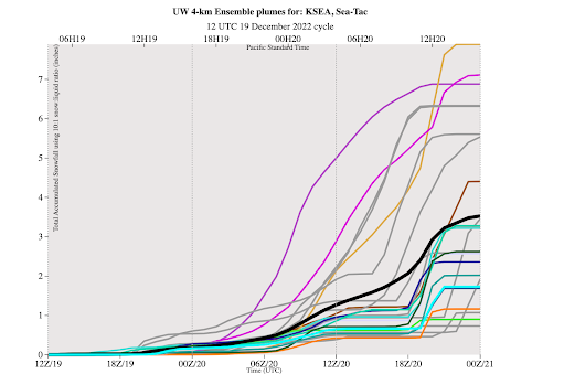
Let me show you what it is predicting for a few locations regarding snow. Cumulative snowfall is on the Y-axis and time is on the x-axis (in GMT/UTC, 18 is 10 AM, 06 is 10 PM PST). Snow depth will be less than snowfall.
Each line is a separate forecast and the black line is the average of them all (often a good forecast).
At Seattle-Tacoma Airport, there are around 3.5 inches of total snowfall, but the uncertainty is large, ranging from .5 inches to 8 inches. The uncertainty is closely coupled with the marginal temperatures for this event. The snow starts this evening.
At Bellingham, there is much more snow and more agreement among the predictions. Why more certainty? Because Bellingham is near the source of cold air (the Fraser River Valley) and sufficiently cold air is a near certainty.
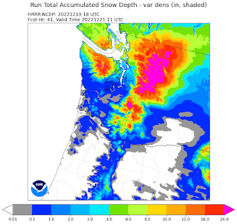
Another powerful tool is the frequently updates forecasts of the NOAA/NWS HRRR model. Its 10 AM run is consistent with the above, with lots of snow over NW Washington and in the mountains, with a substantial north-south gradient in snowfall over Puget Sound (less to the south)

.png)
.png)
.png)
.png)


Thanks for the update. I would love to have you mention Anacortes / Fidalgo Island in Fraser outflow forecasts. Depending on the direction of the wind sometimes we get heavy snow like Bellingham, and other times we seem to benefit from being tucked behind other islands and get lighter snowfall. I would love to know what to expect. NWS seems to group us with "North of Everett" but not Bellingham, which we often are more similar to with storms from the North.
ReplyDeleteWe'll see if the weather channel gets it right again, they've been the only one that has been consistently right about the snow amount recently at least for my area. They are still calling for 5-8" snowfall by tomorrow evening for Seattle to Everett.
ReplyDeleteThank you. Just glad we are not getting the windchill my hometown is gonna be getting. -20s to -40s Though it does appear we will have snow followed by some rather painfully cold weather for Seattle area.
ReplyDeleteI respect you greatly....but every day's forecast for say 2 days out.....gets turned upside down and a vastly different forecast shows up. So i guess a forecast 2 hours out might have a good chance, but nothing else seems accurate. This am, a parking lot in Bellevue, 930am, wet snow, hard....while the NWS point forecast said "20 percent chance of snow before 10. Cloudy"
ReplyDeletegiven plume data often have extreme outliers ... is average the best measure for the expected value or would median be more appropriate?
ReplyDeleteI too would be interested in understanding a bit more about how meteorologists do their model averaging. The 'classical' (frequentist) approach was to model the underlying distribution and given that 'model bias' is of interest, straight up 'averaging' (a mean) would end up being 'efficient' -- but, but, but, always given some kind of methodology for the 'cost of being wrong'.
DeleteMedians and trimmed means and all that was an attempt in Frequentist era to be a bit more robust with sampling distributions that were skew, long tailed, not really gaussian etc.
A big factor here is you certainly can't use simple, classical statistics -- there is no sense in which the distribution of snow fall will be gaussian, if for no other reason than you can't have negative snowfalls! This forces 'overdispersion' in the data I'm sure.
For example, with snow predictions is the cost of overpredicting really the same as the (and in what terms -- economic? hedonic?) cost of underpredicting? Do we want to minimise 'prediction error' or minimise the regret -- think cost/benefits -- of making the forecast?
If I were tackling this problem de novo and blind to prior art, I'd definitely be looking at something simple like using an 'overdispersed' model (negative binomial is a favorite in econometrics and finance)
There's a whole field of (last 20 years) work on how to do Bayesian estimation -- see the work of Michael Jordan (the Mathematician not the Basketball player though that may be relevant too lol) on EM Algorithm for a not too recent of example of the line of research I'm talking about. After all, we don't just pull snowfall accumulation out of an urn as a point prediction -- the models clearly depict a whole process.
I know zip about how model averaging works in meteorology and which 'research avenues' they've chosen or why. I'd be keen to hear more on the hows and whys of this model averaging.
Dumping snow in northern whatcom county, nasty winds, 12° currently. Not pleasant.
ReplyDeleteAre all the predictions in the ensemble equally reliable/probable?
ReplyDeleteSo far, EURO is underperforming with snow totals by quite a bit. GFS latest shows 8+ inches central sound down to about tacoma. Curious what tonights EURO 0z run will show.
ReplyDeleteGhost of Jim Foreman--rained all night in Bellevue.
ReplyDeleteSnwing hard and has been all night above Hood Canal, almost 8".
ReplyDeletewhy doesn't NOAA etc do updates; its 39F and raining hard, but for redmond/bellevue they still claim winter stormwarning...
ReplyDeleteParts of Bellingham received more than 10" as did the San Juan Islands.
ReplyDeleteAt the moment (11:47AM), it's pouring down rain here in Tacoma, but even the Weather Channel is saying it could turn to snow later in the day. Temps now are still 36, but the high is 40. Not certain if we hit it earlier and it's dropping or what. It's a steady, heavy-ish rain with water kind of running down any street that is not absolutely flat in spots and it's nasty.
ReplyDeleteI have a sister that lives on Bainbridge Island and it's been snowing there since early morning and may still be doing so as I type. So it's obviously anywhere south of Seattle is iffy at this point, but as they say, things could potentially change.
The cold air just arrived in Federal Way where it dropped from 42 degrees to 32 degrees in just over an hour. But it's still raining.
ReplyDeleteThey're calling for another ice storm possibility here in Portland for this Thursday - Saturday, which would be a disaster for everyone here, since the last major ice storm (three years ago) paralyzed the area for days on end. They do not have sufficient back up infrastructure for anything more than a half inch of snow, and they never will. I was without power for almost four days and the areas outside of the metro area were without power for over a week. If you don't have electicity you don't have heat, and that's where things get deadly ASAP.
ReplyDelete8"-12" of dry snow at my place about a mile south of the Bellingham Airport with little drifting. This is the single biggest snow event here since we moved to Bellingham 6 years ago. NWS winter storm warning was appropriate even if the snow quantity forecast was on the low side.
ReplyDeleteAs someone that has lived in Bellingham 25 years this is a pretty average snow event. We had more snow than this last year. Funny how people seem to forget weather events. My own grandfather seems to think we never got below 25°f last year. 🤣
DeleteLast year's greater snowfall was multiple events. I was referring to a single snowfall.
DeleteUpdate to my last rant lol....now 34 degrees in Tacoma...and we didn't get 1 flake of snow...and still under a winter weather advisory until 2pm...ummmmm why
ReplyDelete7" in Kingston on Kitsap Peninsula. When the cold front pushed through around 6:30 am snow intensified and dumped 5" in 4 hrs. It's a winter wonderland.
ReplyDeleteStill snowing on Hood Canal...
ReplyDeleteJust picked up again as the cold air moves south, nice little snow machine front moving through. Over 10" earlier today, might get to a foot.
Here in cougar mountain, the forecast using Google weather (from weather.com) keeps changing every 2 hours. We have had probably 2 inches of snow starting the late morning after rain in the earlier part of the day.
ReplyDeleteIt feels like the Canadian GEM was the most accurate for Whatcom County even 5-7 days out. Within 24 hours of the snowfall the Euro did better than the GFS. For the high res models the HRRR pretty much nailed the snowfall totals.
ReplyDeleteThis is widespread. - 2F or - 19c in Kelowna bc now. Roads pure ice. Snowed almost all day. Feel bad for the homeless out there in tents
ReplyDelete4-5" of dry snow in Mount Vernon (easy to shovel this).
ReplyDeleteChiming in again to say that this morning, (12/21) at almost 6AM, it's snowing here in Tacoma. It began last evening, but it's been very fine flakes falling so at best, maybe an inch or so covering everything. Temps here at the moment is 29F. Occasionally, I see bit bigger flakes in the street light but it's coming down.
ReplyDeleteWe finally received the 1 inch that was predicted, but forecast time was about 8 hours incorrect. Why does NOAA (guessing thats behind the tool i stare at for my house ... weather.gov/sew) publish very precise times without some form of "and folks, this is a guess". I can imagine if you hold their feet to the fire on both time and outcome at times predicted their accuracy falls to close to zero. By loosening their time predictions their forecasts are not as bad...
ReplyDeleteDoes this 'January' weather in December suggest that January and February could be worse than the last couple of years?
ReplyDeleteThe UW model did a terrible job with the snow totals for the central sound, and the intrusion of the warm air. Seattle, as I understand it, was not supposed to be overrun with the warm air, but it was and it rained all night. It finally turned to snow in the morning.
ReplyDeleteSeemed generally accurate..where did you perceive a problem?
DeleteAny idea how the power grid is doing in this still, frigid air? Can't imagine there's much wind energy right now.
ReplyDeleteAbout 10% of the Bonneville Power Administration's managed generation capacity comes from wind. Assuming I am reading BPS's realtime report correctly, it looks like there is currently about 1,000 megawatts coming from wind and last Sunday it was 2,000 megawatts (of course, in low wind situations, it can drop to nothing):
Deletehttps://transmission.bpa.gov/business/operations/Wind/twndbspt.aspx