Sometimes in the weather business, everything happens in a short period.
This is such a period.
We will experience:
1. The coldest temperatures in several years on both sides of the Cascades
2. A freezing-rain storm particularly in the Gorge, the northern Willamette Valley, and south of downtown Seattle.
3. Powerful easterly winds reaching hurricane strength in the Columbia Gorge and the passes.
4. A rapid warm-up this weekend, with the return of typical rain and mild conditions.
Stage 1. Arctic Air
Eastern Washington is already very cold, with some temperatures getting below zero last night. Western Washington temps are well below normal.
To illustrate, here are the low temperatures this morning. In western Washington, primo cold air is pushing southwestward through the Fraser River Valley of NW Washington.
Tonight even colder air will move in, coupled with good radiational cooling to space because the clouds are thinning out aloft. Temperatures will drop as low as the teens away from the water in western Washington.
The forecast map (sea level pressure, temperatures shown by shading) for Thursday at 10 AM shows VERY cold air and high pressure over eastern Washington, and simply very cold air (blue) over the west. A HUGE pressure gradient (difference) separates them, with higher pressure to the east.
Stage 2: Strong Easterly Winds
This large pressure difference will drive powerful easterly (from the east) winds through the Cascade passes and particularly the Columbia River gorge. Winds from Cascade Locks to Troutdale in the Gorge could hit 60+ mph--and this will be cold Arctic air from eastern Washington.
Strong easterly winds will also descend the western slopes of the WA Cascades, with powerful gusts from North Bend to Enumclaw, with winds accelerating to the west down the Strait of Juan de Fuca. (see wind gust map at 10 AM Thursday). Greens and blues are the strongest winds.
Stage 3: Freezing Rain
We will have cold air in place. And then a Pacific frontal system with lots of moisture will approach late Thursday evening into Friday morning. A frontal system that will move in warmer air aloft.
Here is the precipitation forecast for 1 AM Friday morning--plenty of moisture.
Now, in the beginning, the precipitation will fall as snow throughout the region.
But that won't last as the front surges in warm air aloft from the south.
And this sets up a freezing rain situation. Let me explain using the figure below.
Initially, (right side of figure) the atmosphere is cold enough for snow through depth (virtually all precipitation in our region during the winter starts as snow aloft)
But as the front approaches, above-freezing air pushes in aloft and the snow starts to melt into water droplets.
Initially, the cold air is deep enough that the melted droplets refreeze into little ice spheres: this is sleet.
But eventually, as the warm air aloft deepens enough, the water droplets aloft do not have time to refreeze but cool down enough to become supercooled water...water that is liquid but still below freezing.
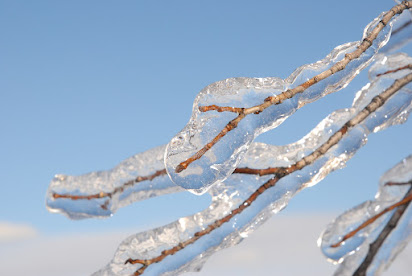
Then, when this supercooled water hits the cold surface (and it will be cold), it freezes on contact...producing freezing rain!
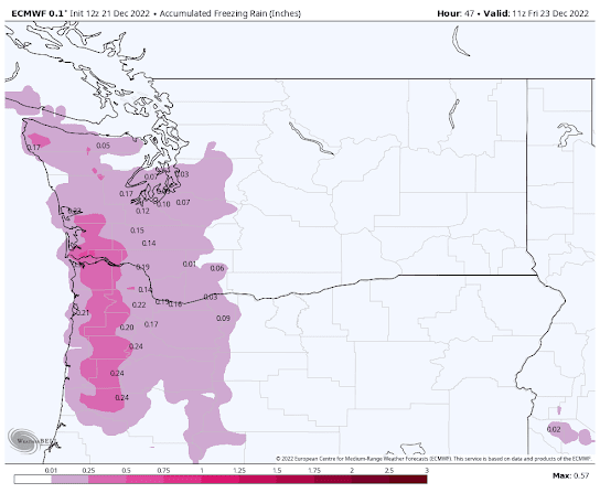
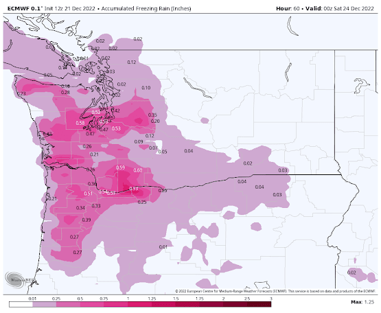
The latest European Center forecast for the accumulation of freezing rain is shown below.
Through 3 AM Friday, the freezing rain total is heavy in the coastal mountains and starts to spread inland.
Through 4 PM Friday, you can see substantial freezing rain totals over south Puget Sound, the Columbia Gorge, and northern Willamette Valley.
And through 4 AM Saturday, the ice piles up in the Columbia Gorge.
On Saturday, it all turns to rain.
Anyway, this looks like a major freezing rain event for the region. The airlines will have to be ready at SeaTac and particularly Portland, with Friday morning being particularly problematic.


great post. didn't seattle get down to 17 last year? maybe 18? are we really going to top that this week in seattle metro?
ReplyDeleteBeat last years 13.2 near Sequim 11.7 this time
DeleteIt's kind of a contest in the PNW for the worst possible weather event - windstorms or freezing rain. I have been through both in both Portland (where I grew up) as well as Puget Sound. The howling winds from the Columbia Gorge can be terrible and bring extended periods of freezing rain to Portland. Freezing rain here is very hard to forecast. Generally, near the Canadian border is the worst, such as in Lynden. The cold air can linger much longer, causing prolonged cooling of surfaces, which take longer to warm up. Overall, severe windstorms do more damage, but the ice storms can be intense if conditions are right. The infamous 1998 Quebec ice storm is the poster child for things going really bad.
ReplyDeleteIF the models are right. Which we all know is not a certainty. Happy Holidays!
ReplyDeleteThis!!!
DeleteHey Cliff, thanks for the post! What are your thoughts on the pass(es), particularly Stevens pass for travel on Sunday/Monday?
ReplyDeleteEnumclaw here. Generator gassed up and ready to go!
ReplyDeleteWell I read one media report that it was due to the cold ground, sigh. But, that does bring up a question about interaction with the ground. Is it correct that freezing rain actually warms the ground because of the exothermic nature of the interaction?
ReplyDeleteCold ground (i.e., surfaces) causing liquid rain to freeze on contact is the basic mechanism. If there is a thin layer of sub-freezing air near the ground, that can contribute to the freezing. However, the sub-freezing layer of air at ground level cannot be too thick, otherwise the water will freeze into sleet before it reaches the ground. Both sleet and freezing rain create dangerous roads and sidewalks, but of the two, freezing rain is the worst in terms of damage to trees and structures.
Deletehttps://www.weather.gov/rnk/Measure_Icing
I'm going with Professor Mass's explanation. Cold ground is necessary but not the primary cause.
DeleteCrazy cold in NE WA. Our house at 1700 ft was -20 F this morning at 5 AM. Driving to work over a low pass at 3300 ft it was -23 F heading up to the pass, and then about -10 F right at 3300 ft. Coldest I have seen in 10 years here.
ReplyDeleteDidn't see this until this morning, but at 9:36AM, it's not bad, but cold out there, it got down to I think 21 last night, or was that this morning when I was clearing the car of snow to go retrieve a friend when he had to drop off their son's car at the shop at 8:30. Earlier that was the temp I saw. The Weather Channel said, 20, and currently it says 21, with the high being 27, the low 24 for tonight, it was one degree different earlier (28-25).
ReplyDeleteAt the moment, still mostly cloudy but the son is trying to poke through the clouds and is quite filtered here in Tacoma and it's still cold enough that is is still present in places.
Christmas Eve, I'm to be on Bainbridge Island at my sister's and back home later for Christmas Day. At the moment, the streets are clear with occasional mini patch of snow or ice in spots but more than passable. The cold has affected my house in that the washer, bathroom sink and toilet do not have water (cold, hot for the sink is OK) The Washer has neither at the moment but the kitchen and shower do have water.
Last year when we had that cold snap just after Christmas, I lost the kitchen sink and the shower too, and a pipe that runs to the back spigot split and what is making it worse is the bathroom got replumbed in 2009 and they stuck the copper to the old galvanized pipes so galvanic corrosion has been taking place... I'll know more when the thaw arrives over the weekend.
14.5 degrees on the Bothell-Mill Creek line this morning.
ReplyDeleteDoes particulate matter in the liquid impact the ability or speed of supercooling?
ReplyDeleteWhere do you get the observation maps (acc. rain, wind gusts, temps, etc) you use in many of your posts? The map I am referring to in this post is the temperature map in section Stage 1.
ReplyDeleteThe NWS significantly underestimated the snowfall in Whatcom County on Monday/Tuesday (2-8" forecast and 9-12 fell across the area) and have just issued a warning for 'up to 2" between 10 pm tonight through 10 pm tomorrow.
ReplyDeleteConsidering both the GEM (which was most accurate earlier this week) and the Euro model both have up to 7" in Whatcom County, this warning does seem low. I guess we shall see which models are correct regarding snowfall amounts.
Perhaps the calculation for the moisture content of the snowfall was off.
DeleteWill there be a last minute update as things get close ?
ReplyDelete