We are currently at the end of the normal lowland snow period in the Pacific Northwest, with the sun rapidly strengthening.
But not this year.
The latest forecasts have significant lowland snow over western Washington during the next few days, with many of you experiencing several inches of the white stuff.
And we have an extended, colder-than-normal period ahead.
Let me give you the details of the forecast.
Today, we have a cold air mass over the region...cold enough to snow anywhere in Washington State. Temperatures dropped into the teens and twenties in western Washington and single digits in eastern Washington (see low temperatures below). Several daily low-temperate records fell last night.

This evening a moist occluded front will approach, spreading precipitation over the region. Snow will move into the Puget Sound region after 8 PM.
Note that the story in the Seattle Times is very wrong, suggesting snow will come in this afternoon around 4 PM. It also talks about an influx of Fraser River cold air later today. Simply not correct.
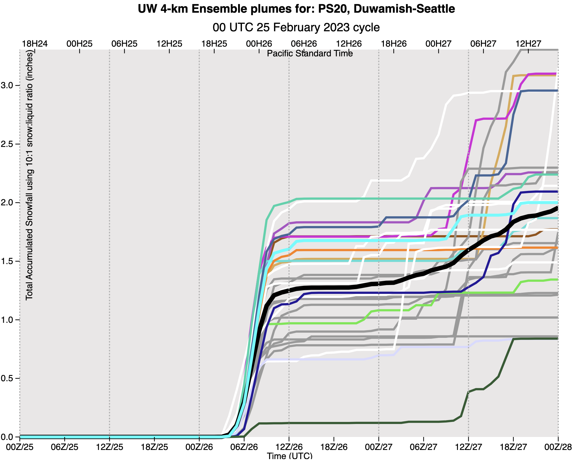
Let me show you the cumulative snowfall totals over Seattle from the most powerful forecast tool available: an ensemble of many high-resolution weather predictions, each slightly different. (Time is in UTC, 06Z/26 is 10 PM tonight). A rapid start of the snow around 9 PM. The black line is the ensemble average....generally a very good forecast. Just under 1.5 inches. And it is all over by around 3 AM.


And folks, this is not the end of the snow threat. 😀

And if you think what is happening here is unusual, the cold, snow, rain, and winds in California are extraordinary and record-breaking for this time of the year.


Zero to almost no snow in much of our part of Kitsap County. I was ready to shovel sidewalks when I got up. I live along Sinclair Inlet, friend is almost at the 400 foot level, and only a dusting. Weird!
ReplyDeletePS I can see snow on the roofs on the Port Orchard side, but not on Manette.
ReplyDeleteThe video coming out from CA today is truly mind boggling, and that's coming on the heels of similar events occuring only a few weeks earlier along much the same areas. If they had only built the additional reservoirs recommended by the Army Civil Corp. of Engineers back in the 70's, so much of their future water worries could be alleviated. Instead most of the precipitation will flow right into the Pacific. We'll then be subjected to more endless stories about Climate Change, while ignoring the human - caused error, once again.
ReplyDeleteUm, climate change is also human caused...
DeleteSo when did it start snowing in Seattle, and what about that cold from the Frazier River Valley?
ReplyDeleteAs far as Bellingham near the airport is concerned, I would say the forecasts were a pretty big miss on snow amounts. Despite the many days of Fraser River outflows and very cold weather, we only got 1/4"-1/2" of wet snow that quickly melted. The NWS forecasts were also pretty inconsistent and even conflicting for this area. The NWS zone forecasts always indicated very little snow, but NWS posted a winter weather advisory for Bellingham that started with 10" of snow, then it was revised to 4", which was still off. Having these conflicts in the zone forecast and winter weather advisory is a little hard to understand. I appreciate the difficulty in this forecasting and perhaps NWS was a little gun-shy after snow misses to the south, including Portland.
ReplyDeleteGot a little more than a mere dusting on cars and roofs this morning, spots of slushy, translucent patches of snow on the streets, otherwise, they were wet, but that all is gone now and everything is dry now at almost 1pm. The snow obviously came after I went to bed and was done at some point overnight as it was not snowing when I awoke sometime between 5-5:30AM.
ReplyDelete3" above Hood Canal, started about 9 or later and finished up around 4 am.
ReplyDeleteThis prediction was much better for the Olympic Peninsula coast than NWS. NWS said we would get maybe 2".... we received about 6" on 2/25.... same with the December storm where we were predicted 3" and received 12"...
ReplyDelete