Special Message:
Could be a major aurora tonight (Sunday) for our region. Lots of clouds right now, but there should be some clearing in a few hours in western WA.
--------------------
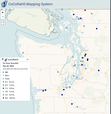
The snow forecast went quite well this morning over western Washington, with portions of central Puget Sound picking up the predicted 1-2 inches (see observed snowfall noted this morning by the CoCoRahs cooperative network).
This was a very difficult forecast, with marginal temperatures. The kind of forecast we could not have done 15-20 years ago.
But there is a downside to this increased forecast skill, a negative impact that directly affected me this morning (see below). I was REALLY looking forward to a pastry and cup of coffee before I went to work at the UW. No luck.

Why difficult? Because major weather prediction models were in disagreement about a crucial weather feature, and we are close to the edge regarding temperatures over western Washington and Oregon.
There have been subtle differences in the location of a low-pressure trough along the Washington/Oregon Coast that influences precipitation, and thus snow, over western Washington.
The European Center was going for more snow over central Puget Sound, but now the latest U.S. GFS model simulation (initialized 6-hr later) has joined in the snowy fun.
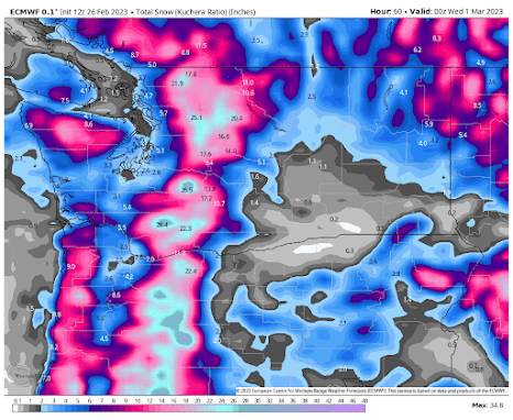
Below are the forecast accumulated snowfall totals for both models through 4 PM Tuesday.
The European Center shows over 3 inches for Seattle and Portland, except right near the water.

The European Center is quite confident snow is in our future. Below are the cumulative snowfall totals in Seattle from the large and excellent EC ensemble system of many forecasts. Each line represents a different forecast run. Virtually every run turns blue (snow). Purple is even more.
The average of the ensemble forecasts for Seattle snow is shown below (light blue bars)--around 5 inches of snowfall is predicted. The solid line is a single higher-resolution prediction....even more.

Tomorrow I will provide more details based on higher-resolution local simulations.
One final note: I ask that no one tells the Grand Central Bakery about the forecast. The reasons are obvious.


Love it - but sorry you didnt get your morning goodies! Thanks for the update. I always trust your knowledge of weather predictions as my guide rather than the hyped up versions that go around.
ReplyDeleteAwesome i hope it dumps🤞
ReplyDeleteShow me the air that's cold enough before we start talking about 5" of snow.
ReplyDeleteAny chance you can also include the ensemble forecasts for the south Puget Sound and north Puget Sound? Not all of your readers are in the central area yet we are also interested. I see we--in Olympia--have a winter storm alert for the early Monday hours.
ReplyDeleteI agree with you on that
ReplyDeleteAt 5 PM the NWS forecast is quite different from Prof. Mass's snow prediction - they're calling for less than an inch on Tuesday. Has something changed in the last few hours?
ReplyDeleteThose two show wildly different scenarios for Bellingham, Vancouver, and SW BC.
ReplyDeleteWeird day in Cle Elum. Dry until 2pm and could see all of the snow stuck at the pass then it moved eastward and dumped 6" of dry snow when only an inch was forecast. Seems like its difficult to predict everywhere not just the west side. So many factors, must be a very complex problem for meteorologists
ReplyDeleteInteresting that the GFS is indicating more snow. Has it been tweaked because of the epic fail in Portland? Just curious how these models work. Are they static or can they be adjusted on the fly?
ReplyDeleteAmazing aurora! Thanks Cliff for the heads up! At first I didn't see it (clouds) but I was seeing vertical tracers in my vision and a green glow to the north at 10:40. I nearly went to bed but a clearing moved over. The northern sky had waving green rays and bright spots coming and going. Already the best I'd seen in the pnw. Then the big event.. at first a massive green blob to the NE and then something reminiscent of a fireworks display, lights exploding out of the bright area. I started laughing, I couldn't believe what I was seeing!
ReplyDelete