Yesterday (Friday, April 28) was the first moderately warm day of the Northwest "summer" season, with temperatures ranging from near 90F along the western slopes of the Cascades to around 70F near the water (see a map of high temps below)

It turns out that the Friday heat was very three-dimensional. Water provided some cooling, but the situation was much, much more complex than that.
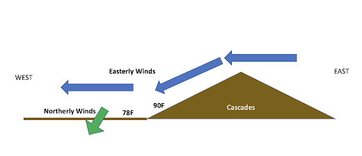
We need to start with the sea-level pressure pattern, with the one at 11 AM Friday shown below. High pressure over eastern Washington and low pressure over northwest Oregon and southwest Washington resulted in an easterly (from the east) wind moving over the Cascades. But at low levels around Puget Sound winds were from the north, since pressures were higher over northwest WA and lower over western Oregon. Near mountains, winds like to go from high to low pressure.

A schematic of the situation around Puget Sound is shown below (sorry, I am not much of an artist). The easterly winds sinking on the Cascades warmed by compression, and thus very warm air was found over the lower western slopes of the barrier.
But the descending air could not reach the western lowlands because of the cool, northerly flow near the surface there. Cold air is denser than warm air and wins the battle to stay near the surface.
Very three-dimensional!
Now the temperatures today (Saturday) are again going to be a complex story...but a very different story.
The pressure pattern has changed greatly. The low-pressure west of the Cascades has now shifted into eastern Washington. Thus, the easterlies over the Cascades are history. And with higher pressure offshore, cool marine air has started to move in.

One sign of this onshore intrusion of marine air is the eastern movement of marine low clouds this morning (see below).

Now let me show you a fascinating figure: the 24 h change in temperature ending 11 AM Saturday.
Mama Mia! Hugely colder today along the coast where marine air is surging in. Yesterday, the easterly, offshore-directed flow made the coast quite warm

Notice how it is warmer today from Seattle northward, where the cool northerly flow has weakened since the north-south pressure difference is less since the low pressure has moved inland.
East of the Cascades today is a bit warmer in general.
Tomorrow, the temperatures will crash in the west as a potent low-pressure system approaches the coast and an associated front makes landfall (see pressure and temperature forecast for mid-day Sunday below).


If it was cooler today than yesterday, it didn't feel it late morning when at a buddy's house mowing his lawn as it got quite warm mid to late morning. The area to mow was not all that large, and the mower was self propelled but had to cut it high, then drop it down and cut it again. Got all sweaty just doing that. It was rather sunny here in Tacoma and was rather pleasantly warm when I headed over before 10AM to his house in University Place. and if the Weather Channel is anywhere remotely accurate, it is currently 76* at almost 5:30pm and very sunny. Almost summer like weather.
ReplyDeleteEither way, it was nice to finally get this type of weather at this time of year.
The max temp at my location in Bellingham on 4/29 (71.7F) was negligibly warmer than on 4/28 (71.5F), a trend that appears to be reflected in the graphic showing 24hr temperature change. Overall, April 2023 was slightly warmer (~0.5 Fahrenheit degrees) than April 2022.
ReplyDeleteI measured 21.1MJ/m^2 of cumulative solar energy on 4/29 - a sign that summer is nearly upon us (peak daily cumulative solar energy at my location is ~25MJ/m^2 around the summer solstice).
ReplyDeleteYup, spring theoretically has just as much solar energy as summer- the curve is symmetrical about the solstice. It almost seems brighter to me in spring, though I am not sure whether that's because solar intensity is increasing so fast or because the air is cleaner in spring.
DeleteAnsel: I'm not quite sure about there being more solar energy in the summer than in the winter. Earth is remarkably temperate - very lucky - in that our orbit around the Sun is ellipical. To quote NASA's Earth Fact Sheet, "Earth is closest to the sun every year in early January, when it's winter for the Northern Hemisphere. And we're farthest away from the sun in early July, during our Northern Hemisphere summer." It's been that way for a very, very long time, and the difference in proximity is significant. What saves us (and makes the northern and southern hemispheres some what different, climate-wise) is the Earth's wobble. The northern hemisphere is "tipped away" from the sun when we're actually closest. The moon is a factor in all this (and the atmosphere has something akin to "tides" of its own, somewhat like ocean tides too). I've recommended from time to time, and I think all weather and climate interested folks should watch this video on YouTube about celestial mechanics. Zip to minute four:
Deletehttps://www.youtube.com/watch?v=9Ml4_Jv_HkE&t=110s
GlacierBake,
DeleteYes I know- I was talking about the solar energy available at our location (Western Washington). And you are right, I know, we are slightly further for the sun in July than in January, but, as you suggest, that will shift over the millennia due to the precession of the Earth's orbit.
I went hiking today in North Bend and one thing that always amazes me is that even after 9months of winter and a healthy snowpack, the soils dry out almost immediately. Today i was on a ridge in a typical pnw unhealthy forest choked with dead brush tinder dry in the hot sun. A fire would have easily started today and its April. Land managers need to start taking forest management seriously because regardless of weather/climate wood burns, and these forests are overloaded with dead wood and pine needles which combust like jet fuel when dry.
ReplyDeleteMy home weather station atop Phinney Ridge recorded a high of 75.4F on 4/28 and 79.9F on 4/29 so it was significantly warmer on Saturday there.
ReplyDeleteThe thermometer is under the eaves of my roof and thus somewhat impacted by proximity to the house but in this case, it shouldn't be much of a confounding factor since the temp was in the low to mid 70s inside the house at the time (different story in winter obv).
These dimensions are fascinating, thank you. Yesterday (Saturday) was warm, but this morning clouds are rolling in from the south where I am, near Mt Baker, at very high speed. Spring is SO dynamic.
ReplyDeleteCalFire is converting a C-130 Hercules for use as a fire-fighting aerial tanker:
ReplyDeleteCalFire C-130 Airtanker Program Update April 25 2023
Cliff - I'm sure you're onto this but will be curious to get your take on what might be the biggest pressure drop/rise in Puget Sound history: https://twitter.com/SeattleWXGuy/status/1653359559560556544?s=20
ReplyDelete