April 2023 has been starkly cool over the Pacific Northwest.
In fact, the second coolest on record in many locations. The coolest in others.
Just look at the April temperatures at Seattle and Pasco compared to normal highs (purple lines) and lows (cyan lines) is enough to put a literal chill down your spine. Most days have had lows well below normal and only ONE day during April reached the normal high in Seattle.
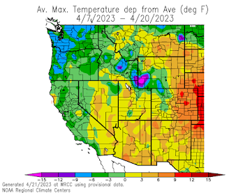
A plot of the differences of temperature from normal for the past two weeks shows uber-cold maximum temperatures (blue color, 6-9F below typical) for much of Oregon and Washington.

This is historic cold. For example, at Olympia, the average maximum this month so far was the COLDEST on a record going back over 80 years! In Seattle, it was the second coldest (2011 was the chilly winner).
.png)
The bad news? We will have to endure a few more days of these frigid conditions.
The good news? In roughly a week, a strong ridge of high pressure will build over the region bringing MUCH warmer conditions...we are talking about highs around 70F in western Washington, and nearly 80F in the Columbia Basin. Can you imagine this?
Below is the forecast upper level (500-hPa pressure) heights for 5 PM Thursday. Mama mia, that is a nice ridge of high pressure!

Now consider the latest forecast from the National Weather Service National Blend of Models for SeaTac (below). Low 70s on Friday and Saturday! Spring!

And if you can't afford Palm Springs, take a drive to the Tri-Cities. Pasco will be above 75F for at least a week and get very close to 80F. Just perfect. Not a bad time to check out the wineries in eastern Washington or enjoy the wildflowers over Rangeland country.


Any chance we'll get some rain with those higher temperatures?
ReplyDeleteNope. Offshore winds are not conducive to precip until later in summer when monsoon moisture can be wrapped around.
DeleteAnd the monsoon moisture rarely reaches the West side of the Cascades even then. I miss the thunderstorms that bring rain to most of the rest of the country.
DeleteAbout time. I think we may have hit mid 50's once or twice this month, at best. Typically, mid to upper 50's with periodic showers here and there and May is very pleasant with temps mid 60's to mid 70's with occasional forays into the mid 80's but it's been decidely cool and and occasionally wet, but not not as wet as it has felt though.
ReplyDeleteGlad to see some normalcy weather wise coming.
The max temp at my location in Bellingham on 4/22 was 59.3F - the warmest of the month so far and warmest since 3/29.
ReplyDeleteCold April has kept the daffodils in full bloom long after usual in the Skagit Valley.
ReplyDelete