The sky this morning was beautiful (see below). An impressionist's dream.
What you are seeing is mid-level convection: shallow cumulus clouds resulting from instability in the middle troposphere (I will explain this later).
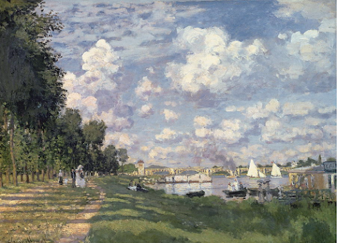
French impressionists loved such beautiful skies, as illustrated by this lovely painting by Monet (The Port at Argenteuil)Here is another one by Monet that was even more similar to what I viewed this morning. Monet should have been a meteorologist.....
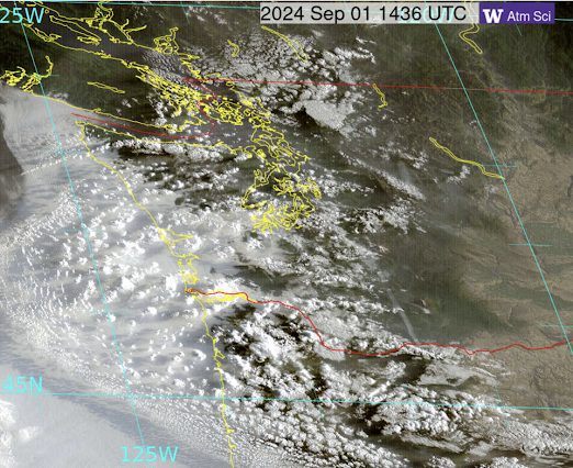
In 2024, we could do something Monet could not have dreamed of....to observe such clouds from space. And for your viewing pleasure, below is what NOAA's GOES-West satellite observed at almost the same time as my picture above.
Do you see the small cloud elements over western Washington and northwest Oregon? These are the features of interest.
We can tell the elevations of these cloud elements by using another high-tech sensor system that Monet could not have dreamed of: laser ceilometers maintained by the Puget Sound Clean Air Agency. These surface-based units use vertically pointed laser beams that scatter off clouds and smoke (see below). The time it takes for a scattered beam to reach and return from the cloud provides the cloud height.
The clouds in question formed 5 and 6 kilometers above the surface (roughly 16,000 to 20,000 ft above sea level ) around 1:30 AM this morning.
But our high-tech bag of tricks does not end there! We have balloon-launched weather stations called radiosondes around the region, including Quillaytue on the Washington coast and Salem, Oregon.
Here is the temperature (red line), dewpoint (blue dashed line), and winds from thelayer radiosonde launched this morning at Salem, which is positioned in the middle of the cloud field. Temperature (°C) is on the x-axis and height in pressure (hPa) is on the y-axis. 500 hPa is about 18,000 ft.
There is a layer (indicated by the red arrow) in which the dewpoint and temperatures are the same. Such a layer is saturated (100% relative humidity) and is associated with clouds. Matches the ceilometer height quite well. The red temperature line also shows that the temperature was declining rapidly with height in that area, consistent with an unstable, well-mixed layer.
So why do we have these beautiful cumulus clouds in that shallow layer?
It was associated with an approaching low-pressure center aloft (see upper level, 500 hPa, about 18,000 ft)--as shown by the forecast map for 8 AM this morning. In front of the low (to its NE) there is both upward motion and southerly winds. Upward motion causes air to cool (air cools by expansion when as it moves to lower pressure), which causes the relative humidity to increase (because cool air can hold less water vapor than warm air). The southerly (from the south) winds also helped move some moist air up from the Arizona "Monsoon" region.
Another high-tech capability is to view water vapor from space! Such imagery shows the moisture plume this morning


I was outside taking in the beautiful sunrise today. I too noticed the beautiful mid-level clouds, many showing virga, which made them all the more beautiful.
ReplyDeletethanks for the complex and coherent discussion, Cliff
ReplyDeleteVery well done. Thank you.
ReplyDelete