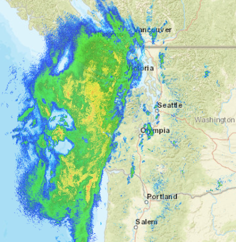
Yesterday, the first strong Pacific front of the season moved off the Pacific Ocean.
There are some fascinating subtleties of how Pacific fronts such as this interact with our region's terrain....let me show you!
The radar image around 8 AM yesterday (Wed) morning shows precipitation from the front reaching the WA coast and NW WA. Green indicates light rain, yellow moderate, and red, heavy precipitation. Umbrella alert.
By mid-afternoon, the front was moving through and the winds on the coast had switched from southerly (from the south) to northwesterly. As a result of this wind shift, a rain shadow started to develop over the north Sound as northwesterly winds descended the northeast slopes of the Olympics (I have indicated the rain shadow with a red arrow).
The visible satellite image of the front around 1 PM is shown below. The red line is the approximate location of the surface front, cold unstable air is behind (the area with white cloud elements over the ocean)
What is so exciting for me as a modeler, someone who simulates the atmosphere using complex physical models, is that the forecast models nailed this front in the days before.
Let me show you. A high-resolution forecast made the day before, produced simulated clouds very similar to those observed (see below).
An even higher resolution prediction from the previous day shows the primary front rainband and amazingly gets the arc of precipitation moving into the north Sound.
And yes, the high-resolution forecast correctly forecasts the location and timing of the Puget Sound convergence zone.
The advances in high-resolution weather prediction are amazing. How can we do it?
Vast satellite-based observational assets provide a good description of what is going on over the Pacific in three dimensions. Then high-resolution weather prediction models simulate the detailed interactions of air coming off the Pacific with our complex regional terrain.
We have come a very long way during the past few decades, providing far better forecasts and helping warn/protect the region's population.
_____________________________
Announcement: Free Public Lecture at Kane Hall on October 10: Global Warming, the Jet Stream, and Cold Waves
All of you are invited to attend what should be an excellent public lecture by Professor Jonathan Martin on how global warming affects the jet stream and cold air outbreaks.
It will be a timely and interesting lecture accessible to non-meteorologists and given in honor of UW Professor Peter Hobbs.
The talk will be at 7 PM in Kane Hall room 210.
If you would like to go, please register online here:
Parking is available (at a modest cost) in the UW Central Garage, which is located directly under Kane Hall. Or take the light rail (the UW stops are a 5-10-minute walk away).


Thanks for the notice on the lecture - this is something I find interesting and will attend.
ReplyDeleteGreat post. Here in Glacier we were slammed with 12 hrs of steady rain, 1.75" of precipitation that fell from 10:30 am through 10:30 pm. We're seeing another wave coming in. Yes, it's fall. Yes, we're back to the traditional pattern. And the "rain year to date" numbers (re the continuing drought) have actually reached very near 95% here. I'll be running the year-end totals on my own long-term spreadsheet. (That data's also available at CoCoRaHS's "active map" for reported locations; all based on actual data entered but there's a page with calculations - "Data Explorer" links exist for each station location 'dot'.)
ReplyDeleteThanks for the impressive review.
ReplyDeleteWill the lecture be available for remote viewing?
Cheets,
Tom
I am ALWAYS enlightened by your podcasts. I love that you tell it like it is. I hope you don't get a bunch of flack for bucking the headwinds of climate alarmism... Again thanks.
ReplyDelete