We may break a significant record tomorrow, with the rapid development of the deepest low-pressure center (lowest sea level pressure) on record for the coastal waters of the Pacific Northwest.
For the period of the historical record, the lowest reliable central pressure for any Pacific low-pressure area off the West Coast occurred on October 24, 2021. I even did several blogs about the event at that time. As shown in the figure below, at its most intense that storm had a central pressure of 943 hPa.
The latest model run of the U.S. GFS model predicts that tomorrow's storm will have a low center of 942 hPa
While the European Center has the center at only 943 hPa.
The fact that multiple forecast models are coming up with the same solution provides great confidence in this forecast.
Ready to be impressed? Such low-pressure centers are consistent with the central pressures of a category 4 hurricane as shown by the official Saffir-Simpson scale (below). No need to head to Florida for big storms!
This offshore storm and its associated front will bring major winds to the coast, with coastal winds gusting to 50-65 mph around 6-8 PM tomorrow evening (see predicted winds at 7 PM Tuesday, kt). Winds will be even stronger over the western portion of the Strait of Juan de Fuca, with gusts above 70 mph.
Coastal flooding will be reduced by the easterly component of the wind, which will act to push water away from the coast.
But as noteworthy as all this is, the big weather story will be in the western Washington interior, where a ferocious easterly wind will descend the western side of the Cascades, undoubtedly resulting in the loss of power to thousands.
I am charging my electronics and flashlights right now.
We have a very interesting...and threatening situation developing. To the west, a record-breaking low pressure center is developing. But to the east, just the opposite: cold air is leading to higher pressure than normal.
Below is the pressure pattern at 10 PM tomorrow night. The solid lines are isobars, lines of constant sea level pressure. The colors indicated low-level temperatures, with blue being cold and yellow indicate warm.
The combination of the low offshore and inland cold high results in a crazy intense pressure change over the Cascades.
As shown by the latest high resolution UW forecast of the winds for tomorrow evening around 7 PM, strong easterly winds gusting to 40-60 kt will hit the region from the Cascades to the Sound, and from an unusual direction (from the east).
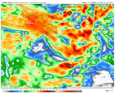
The NOAA HRRR model does something similar (winds in mph)
These kinds of winds will take out power to thousands: not only will they be strong, this is early season, and the direction is unusual for the powerful winds. Vegetation is not used to it.
In Seattle, the southern part of the city is most vulnerable to such strong winds. Whidbey and the San Juans will be hit hard.
You have been warned. 😉


Thanks for the update Cliff. I really appreciate your insights and have silently followed the blog for years. You are my go to for interesting weather in the PNW.
ReplyDeleteAs the wind is from the east, why is Whidbey vulnerable, versus the westerly side of Puget Sound?
ReplyDeleteI think it has to do with the Olympic Mountains operating as a wind shield for winds coming from the east (easterly winds will be pushed to the north and south of the Olympics.) Whidbey Island is far enough north and east of the mountains to gain protection.
Delete😉 Stay safe everyone.
ReplyDeleteAt 9pm PST Nov 18, I noticed an odd line of opposing wind starting in the North at the Russian coast of the Bering See and going straight south almost all the way to Midway Island. The wind to the East of the N/S line was coming from the S and SE and the wind on the West side of this line was coming from the W and NW. Have you see this before? I noticed it the iKitesurf.com website. They use a Flow Map set to Blended Numerical Weather Prediction Model. GFS and CMC showed the same. I took a screen shot of it. I'll try to figure out how to email it. Maybe this is a common occurance. I have not seen it.
ReplyDeleteAny reason why big storms in the Pacific Northwest are not named by the World Meteorological Organization as Atlantic hurricanes are using a rotating list of names that alternate between male and female?
ReplyDeleteThat East wind, will be blowing against a huge fir tree that is about 70 feet away from my home, and right in line with my bedroom!...Nice knowing you all! Lots of branches will be filling up my backyard....or maybe my entire house!
ReplyDeleteSimilar, we had an arborist "take the sails out" of our firs.
DeleteThe table you display says cat 4 pressures bring winds of 130 - 156 mph so why are we only getting 55-70 mph?
ReplyDeleteLack of warm water for fuel.
DeleteFortunately these monster lows almost always veer away to the north instead of making landfall. Cliff - what makes them do that.. veer off to the north so often? Is it the high pressure over land to the east that deflects them to the north? If that's the reason, why does the high pressure over land always overpower the low over water?
ReplyDeleteCliff, this would be an interesting topic for a post. I'd also like to know what the chances are of a powerful system like this making landfall
DeleteWhat will this mean for the Walla Walla Valley?
ReplyDeleteYou mentioned the winds are coming from an unusual direction but, for the foothills, I feel like they are always coming from the east when it's strong winds. I'm assuming that is more a warning for other parts of the state?
ReplyDeleteSo why did the NWS forecast for SeaTac only call for gusts to 33 mph?
ReplyDelete