I may be reticent about publicly forecasting the outcome of the presidential race tomorrow, but I am increasingly confident about another issue of interest, skiing during the Thanksgiving holiday weekend at the higher elevation runs.
The last few model forecasts give me some confidence that at least Whistler, Baker, and Crystal will be able to start their season.
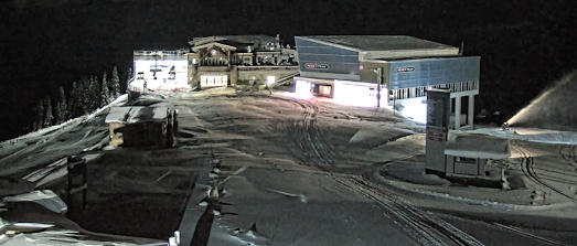
Let's start with Whistler/Blackcomb. During the past week, they have gotten several inches with a current base of around 25 cm (roughly 9 inches). The cam at the mountain lodge shows the snow cover and the fact they have even started to make snow (see the snow gun on the right).
There was some additional snow today but the big accumulation will be this weekend and beyond, when a deep trough over the northwest Pacific will really get the flakes falling.
Consider this morning's run of the uber-skillful European Center forecast model. The snowfall totals are in cm, so remember 1 cm is about 0.4 inches
The total by tomorrow morning is about 25 cm (roughly 10 inches) at Whistler.
With a wet system coming in Friday and over the weekend, by next Thursday morning there will be about 82 cm (32 inches) at Whistler. That alone may be enough to open some runs.
The forecast model run by my group, driven by the US GFS solution, is similar (and in inches). Our snow totals are a bit more generous:
Certainly, the folks at Whistler are optimistic:
Mt. Baker ski area will get a piece of this snowy action. Currently, there is about a foot of a decent base there, as noted by Gwyn Howat, CEO of the Baker Ski area. Crystal, as will Mt. Baker, will get enough to open I suspect.
I am not suggesting that the lower ski areas, Snoqualmie and Steven, will open. Too low, too warm for so early in the season.
The big question is what will happen in mid to late November. Too far ahead for skillful forecasts....so keep tuned!


Whistler historically always opens by US Thanksgiving weekend. They only require low temps sufficient for their snowmaking operation to function. However, snowmaking coverage is limited to main runs so the real early season win is when they can open the off piste sections....
ReplyDeleteThis year they will open a week before our Thanksgiving since our Thanksgiving is so late. Whistler's opening date is the 22nd. Looking pretty promising so far!
DeleteWatching the snowshoe trails; looks like another week before its cold enough to get lower mountain snow.
ReplyDelete