If you read media reports, such as in the Seattle Times, one is told that the localized winds on Tuesday evening were the result of an unusually deep "bomb cyclone".
Some of the more irresponsible outlets stated that this event was the result of climate change.
As described here, the truth is far more complex and nuanced.
Reality Check
A major issue is that the intense cyclone was well offshore, with only modest local impacts from the storm's strong winds.
Consider the highly accurate regional forecast of sea level pressure and near-surface winds (color shading) at 7PM, near the height of the wind event over western Washington. The storm center was about 380 miles offshore!
The powerful winds directly connected to the low center were hundreds of miles out in the Pacific, with a band of strong winds associated with a front over the coastal waters of the region.
You will notice a strong pressure difference (gradient) across the mountains, with higher pressure to the east. THAT pressure difference is very important since it helped drive the easterly (from the east) winds over the western slopes of the Cascades.The low pressure offshore contributed to the pressure gradient across the Cascades, but so did unusually high pressure west of the Cascade crest, something shown by the pressure anomaly (difference from normal) map below.
This inland high pressure was associated with COLDER than normal air east of the Cascade crest (see temperature map at around 5000 ft below).
In short, the critical pressure gradient across the Cascades had two contributors: low pressure offshore and high pressure inland. Yes, the powerful offshore low contributed, but a much weaker low, closer to the coast, could have done the same thing.
The winds approaching the crest level of the Cascades were strong from the east/southeast, as shown by the weather map at 850 hPa (around 5500 ft). The wind barb shows 35 kt from the east-southeast. At this level, you can see the cold air (blue colors) banked up against the eastern slopes of the Cascades.
Finally, we can view the simulated vertical structure of the air approaching the Cascades that night near Stampede Pass (see model vertical sounding below). The x-axis is temperature and the y-axis is height. On the right are the winds. The red line is temperature and the blue line is dewpoint.
And that is EXACTLY what happened. The area east of Puget Sound experienced strong winds not directly associated with the "bomb" cyclone but from something else: a downslope wind event.
Below is an east-west vertical cross-section across the Olympics and Cascades from a very high-resolution model forecast at 7 PM, with winds shown by colors (purple is the strongest, followed by red). There are strong winds along the coast, but a separate area of high wind speeds is found on the western side of the Cascades. That is the downslope wind event that caused all the problems. Look closely and you will notice a waveness in the wind strength associated with atmospheric gravity waves.
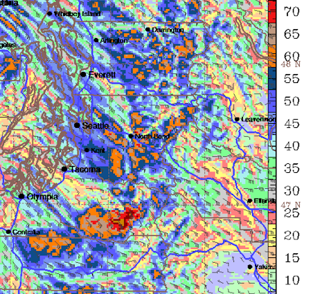
Examining the surface wind speed and direction at the same time for western Washington, you can see the strong winds (kt), indicated by orange and red colors. Look closely and you can see some waviness and non-uniformity in the winds.

There was a lot of structure in the winds on Tuesday evening, with locations only a few miles away experiencing very different wind strengths. The winds were also very gusty in nature. At my home, there were gusts to around 60 mph one second and nearly calm the next. These are characteristics of downslope wind events.
Below are the maximum wind gusts on Tuesday. HUGE variation both locally and regionally. Winds were less over the South Sound since this area was in the wind shadow of Mt. Rainier. Lesser winds west of Puget Sound.
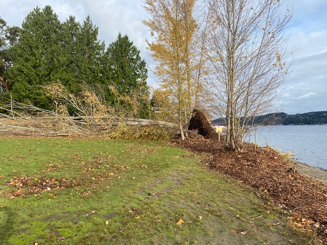
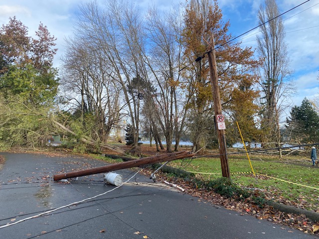
Yesterday I surveyed the damage around NE Seattle and was stunned by the contrasts.
At Mathew Beach Park, lines of huge trees were downed and a power pole was snapped off.
This was an extreme local event and a lot of meteorological pieces had to come together to make it happen. Much more than an intense low center almost 400 miles off our coast.
I worry that the media has not been accurate in describing the origin of this event and its great predictability. "Bomb" headlines and other hype have replaced careful journalism. Importantly, saving lives in the future relies on the truth about such events being accurately communicated by the media and other information sources.


Media's motto: Money over Truth
ReplyDeleteYes, it was disappointing but not surprising at all to see CNN jump all over the "bomb cyclone" narrative, connect it to climate change, and suggest this will be the new norm. These people know nothing about what they are talking about, it's irresponsible and reckless. I didn't check the Seattle Times, but I suspect they likely did something similar.
ReplyDeleteIt was also surprising not to see a comment stating it was satisfying to see Fox News jump all over the “bomb cyclone” narrative and connect it to the climate change hoax.
DeleteThank you (again!) Cliff, for a detailed but accessible (for a layman) explanation regarding the wind event. A voice of sanity that is greatly appreciated.
ReplyDeleteI drive Uber. On Friday, one of the folks I gave a ride to was absolutely convinced (by news reports) that a literal bomb had been set off in the atmosphere that caused all the damage. The media are just irresponsible in how they describe this. And then today the Times piles on with a nonsensical article on how having distributed power generation would have someone protected against the outages, without any mention of the fact that renewable power is not reliable and must be 100% backed up with reliable sources meaning the grid must stay in place. It's all in pursuit of the political narrative that people must give up their liberty to get safety.
ReplyDeleteI agree that it's definitely irresponsible journalism, but also, if there is someone stupid enough to believe that a bomb was set off in the atmosphere, there's not much you can do for people like that. Sadly, that's who these people are praying on, easy marks.
DeleteToby, did you educate your passenger as to what "bomb cyclone" really means?
DeleteGreat info, Cliff! You really have clarified for me, as to WHY those winds were erratic, unusual (Easterly), and very sporadic. I love living in the NW, where our weather is so interestingly influenced by the topography, and pressure differences. That offshore monster storm would have been so much more responsible for the damage, had it been a couple hundred miles closer to our shores. Hee in S. Everett, the damage was mostly moderate, but with a few smaller neighborhoods getting hit harder than than the surrounding areas.
ReplyDeleteWe live very near a Bellevue Greenbelt, “Weownapark”. It sits above the west side of Lake Sammamish. Our neighborhood is usually hammered by high wind events, but not this time. Perhaps the Greenbelt buffered the winds some way. We didn’t lose power or have any damage. But as close as 0.5 miles away, there was extensive power loss and 2 miles away, devastation. I wonder how many houses in the path of the storm had trees fall on/through.
ReplyDeleteThanks Cliff.
ReplyDeleteThe region needs, and has, some well-trained arborists. The folks that take the big trees off of houses. Searchup some of their videos – and be amazed!
Well, we were out of power for about 3 /1/2 days. We live in Redmond! This hasn't happened since the 2006 Hanukah storm. Before that.......the 1993 Inauguration Day storm. We get these windstorms of great magnitude every 10-15 years. I tell people there have even been worse ones like the 1962 Columbus Day storm. If I recall, there were some others.........one sank the hood canal bridge and another in the 80s disrupted Thanksgiving for about 500,000 people. It will be interesting to see what this La Nina winter has in store for us in the Northwest. Low land snow perhaps??? Thanks Cliff..........you are the go-to guy for weather around here.
ReplyDeleteI see this a technicality. The giant occluded front that triggered the mountain waves didn’t come out of nowhere and without the big low offshore you wouldn’t get the wind reversal that you need to have a critical level. So no bomb cyclone = no windstorm.
ReplyDeleteJoe.... it did not have to be a rapidly developing "bomb" cyclone. A weaker, but closer in cyclone would do. That is one point, the other is the importance of the high pressure anomaly to the east....which was needed to get the severe response...cliff
DeleteInteresting, Issaquah got clobbered while North Bend saw limited damage which is consistent with the forecast map. Good thing to, that was the only place with grocery stores that did not lose their perishable inventory. That's impressive, what software was used for that?
ReplyDeleteQuite a few of the houses crushed by big fir trees are sitting in woods surrounded by 100 foot tall firs. A good arborist can take the sails out of these firs by removing about half the branches. So that firs are much more resilient to twisting in high winds that causes them to topple or snap. A public service announcement by the state gov would help a lot of people.
ReplyDeleteThank you Cliff for your interesting explanation of the cause of downslope winds. I live near Enumclaw and was here for the Christmas 1983 storm when the Miles City pressure set a record. I just reread Chapter 8 in your "The Weather of the Pacific Northwest" book and it looks as if the offshore low was quite a distance off shore and to the South for that storm. So this past storm had a somewhat similar setup where the main factor was the high to the East.
ReplyDelete